Size of this preview:
450 × 600 pixels. Other resolutions:
180 × 240 pixels |
360 × 480 pixels |
576 × 768 pixels |
768 × 1,024 pixels |
1,536 × 2,048 pixels |
2,700 × 3,600 pixels.
Original file (2,700 × 3,600 pixels, file size: 2.58 MB, MIME type: image/jpeg)
| This is a file from the
Wikimedia Commons. Information from its
description page there is shown below. Commons is a freely licensed media file repository. You can help. |
Summary
| Description |
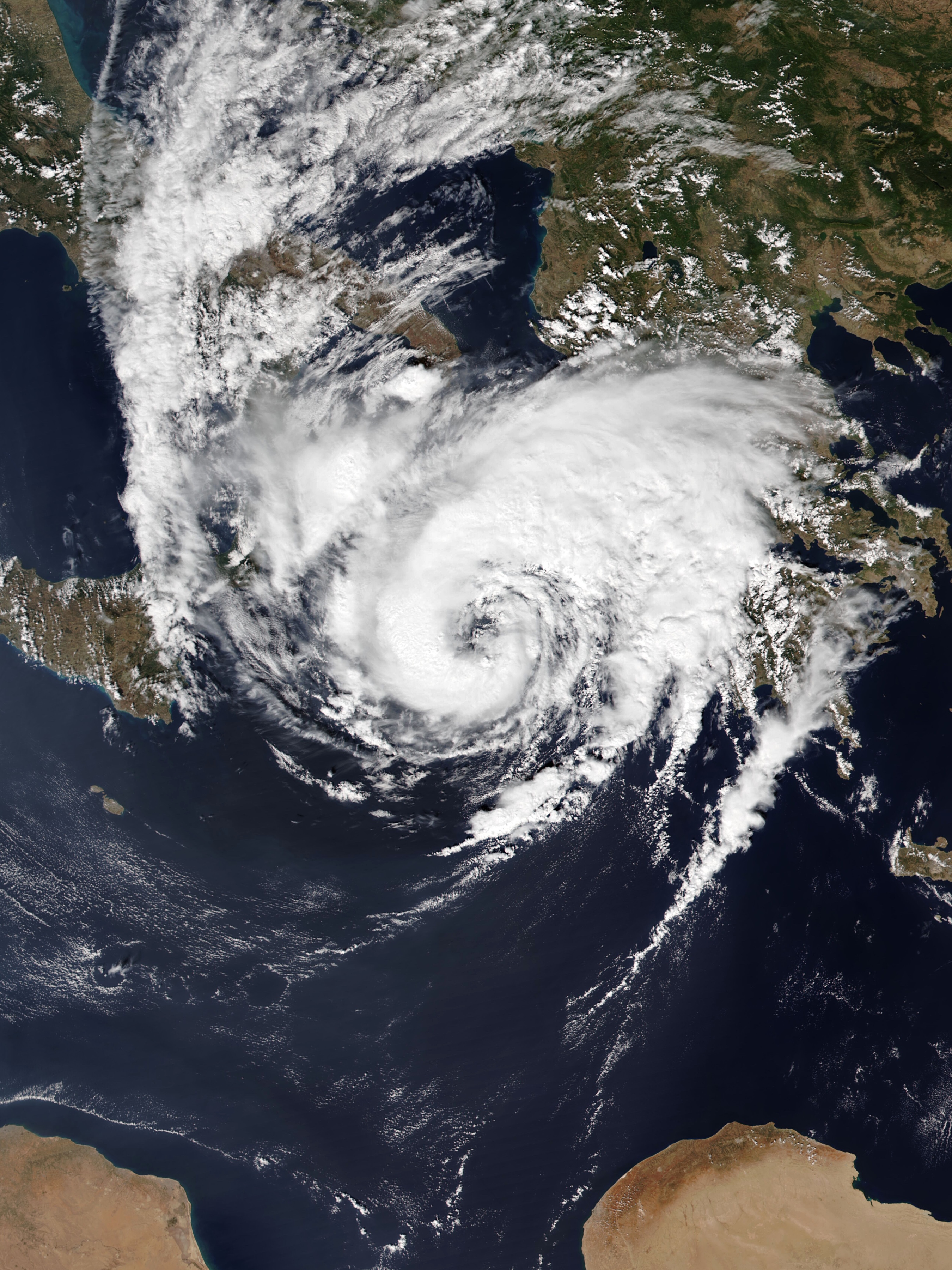
English: Medicane Ianos approaching Greece at peak intensity on 17 September 2020. |
| Date | |
| Source | EOSDIS Worldview |
| Author | NOAA-20 satellite for the VIIRS imagery |
| Camera location |
| View this and other nearby images on: OpenStreetMap |
|
|---|
Licensing
| This file is in the public domain in the United States because it was solely created by NASA. NASA copyright policy states that "NASA material is not protected by copyright unless noted". (See Template:PD-USGov, NASA copyright policy page or JPL Image Use Policy.) | ||
 |
Warnings:
|
File history
Click on a date/time to view the file as it appeared at that time.
| Date/Time | Thumbnail | Dimensions | User | Comment | |
|---|---|---|---|---|---|
| current | 13:23, 18 September 2020 |
| 2,700 × 3,600 (2.58 MB) | Meow | Uploaded a work by NOAA-20 satellite for the VIIRS imagery from [https://worldview.earthdata.nasa.gov/?v=8.240741788456058,30.393939631467802,28.78713282827905,42.83925213146779&t=2020-09-17-T12%3A55%3A52Z&l=Reference_Labels,Reference_Features,Coastlines,OrbitTracks_NOAA-20_Ascending(hidden),VIIRS_NOAA20_CorrectedReflectance_TrueColor EOSDIS Worldview] with UploadWizard |
File usage
The following pages on the English Wikipedia use this file (pages on other projects are not listed):
- Cyclone Ianos
- Mediterranean tropical-like cyclone
- User:Atomic7732/Mediterranean tropical cyclone
- User:HurricaneKappa/Sandbox/Hurricane infoboxes for all Medicanes/Cyclone Ianos
- User:HurricaneKappa/Sandbox/Hurricane infoboxes for all Medicanes/Medicane Ianos
- User:LightandDark2000/My Notable Storms
- User:Rosalina2427/Archive4
- User talk:12george1/Archive 28
- User talk:AySz88
- User talk:ChessEric/Archives/2020/October
- User talk:Chicdat/Archive 4
- User talk:CooperScience
- User talk:CycloneFootball71/Archive 1
- User talk:Cyclonebiskit/Archive19
- User talk:Destroyeraa/Archive 2
- User talk:Dylan620/Hurricane
- User talk:Hurricane21
- User talk:HurricaneSpin
- User talk:Hurricane Noah/Archive 5
- User talk:Hurricaneboy23
- User talk:Iseriously
- User talk:Iune
- User talk:JackGordean
- User talk:Janm 7/Archive 1
- User talk:Jo-Jo Eumerus/Archive 79
- User talk:Jupiter50
- User talk:KN2731/Archive 4
- User talk:Nova Crystallis/Archive 5
- User talk:Presidentofyes12
- User talk:The Grid/Archive 9
- User talk:Titoxd
- User talk:TornadoLGS/Archive 1
- User talk:WmE
- User talk:X!/Archives/10/2020
- User talk:Yellow Evan
- Wikipedia:Main Page history/2020 September 25
- Wikipedia:Main Page history/2020 September 26
- Wikipedia:Main Page history/2020 September 27
- Wikipedia:Main Page history/2020 September 28
- Wikipedia:Main Page history/2020 September 29
- Wikipedia:WikiProject Severe weather
- Wikipedia:WikiProject Tropical cyclones
- Wikipedia:WikiProject Tropical cyclones/Newsletter/Archive 43
- Wikipedia:WikiProject Weather
- Template:WikiProject Weather navigation
Global file usage
The following other wikis use this file:
- Usage on ar.wikipedia.org
- Usage on cs.wikipedia.org
- Usage on de.wikipedia.org
- Usage on el.wikipedia.org
- Usage on fa.wikipedia.org
- Usage on fi.wikipedia.org
- Usage on fr.wikipedia.org
- Usage on fr.wiktionary.org
- Usage on id.wikipedia.org
- Usage on ko.wikipedia.org
- Usage on pt.wikipedia.org
- Usage on sl.wikipedia.org
- Usage on vi.wikipedia.org
- Usage on www.wikidata.org
- Usage on zh.wikipedia.org