
Original file (3,404 × 2,269 pixels, file size: 4.44 MB, MIME type: image/jpeg)
| This is a file from the
Wikimedia Commons. Information from its
description page there is shown below. Commons is a freely licensed media file repository. You can help. |
_lrg.jpg)
Summary
| Description |
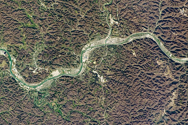
English: Charleston, the capital city of West Virginia, is nestled in the
Allegheny Mountains, one of the smaller ranges running through the Appalachians. The brown-hued, textured areas—not yet painted green by springtime—highlight the ruggedness of the surrounding terrain and allow local cities, roads, and mines to stand out in this photograph taken by an astronaut from the International Space Station (ISS).
Established in the 1700s, Charleston sits in a river valley at the confluence of the Kanawha and Elk rivers. The Kanawha River, named after the Kanawha Native American tribe, is a tributary of the Ohio River and is only about 160 kilometers (100 miles) long. Due to the region’s undulating topography, much of the Allegheny Mountain Range was historically difficult to travel across as early European settlers headed west. Throughout Charleston’s development and expansion, its riverside location made it a welcome resting spot for settlers along their route west, and many chose to stay in the region permanently. Salt works, logging, and mining would become the city’s leading economic industries. Brine has been pumped from wells in this area for its salt content for hundreds of years. Logging became prevalent due to the abundance and variety of trees in the mountains. Underground coal mines, which date back to the early 1800s, are scattered throughout West Virginia. In the 1970s, coal operations started using a process known as mountaintop mining: the removal of rock and soil from mountaintops to reach coal seams. Since the process starts with the complete deforestation of an area, such surface mines can bring large-scale changes to the landscape and environment.Deutsch: Charleston, die Hauptstadt von West Virginia, liegt eingebettet in die
Allegheny Mountains, einer der kleineren Gebirgszüge in den Appalachen. Die braungefärbten, struktuierten Gebiete — die noch nicht vom Frühling grün verfärbt sind — unterstreichen die Zerklüftetheit des umgebenden Geländes. Dies ermöglicht, daß Orte, Straßen und Bergbauanlagen in dieser Photographie, die von einem Astronauten der Internationalen Raumstation (ISS) angefertigt wurde, herausstechen.
Das gleich zu Beginn des 18. Jahrhunderts gegründete Charleston liegt in einem Flußtal an der Mündung des Elk River in den Kanawha River. Der Kanawha River, benannt nach dem Indianerstamm der Kanawha, ist ein etwa 160 km langer Nebenfluß des Ohio River. Aufgrund der welligen Topographie war ein Großteil der Allegheny Mountain Range schwer zu bereisen, als die frühen europäischen Siedler nach Westen zogen. Während Charlestons Entwicklung und Expansion machte es seine Lage am Fluß zu einem willkomemen Rastplatz für die Siedler auf ihrem Weg nach Westen, und viele entschieden sich, für immer in der Region zu bleiben. Salzgewinnung, Holzwirtschaft und Bergbau wurden zu den führenden Wirtschaftszweigen der Stadt. Lauge wurde in diesem Gebiet wegen ihres Salzgehaltes über hunderte von Jahren aus dem Boden gepumpt. Wegen der reichhaltigen und vielfältigen Wälder in den Bergen wurde die Holzwirtschaft zum dominierenden Wirtschaftszweig. Untertagebergwerke für Kohle kamen zu Beginn des 19.Jahrhunderts auf und sind durch ganz West Virginia verstreut. In den 1970er Jahren begann man im kohleabbau mit der Technik des " mountaintop mining": der Entfernung von Felsen und Erde von den Bergspitzen, um die Kohleflöze im Tagebau zu erreichen. Weil dabei ein Gebiet vollständig abgeholzt wird, bringen solche Tagebaue umfassende Änderungen von Landschaft und Umwelt mit sich. |
| Date | |
| Source | https://earthobservatory.nasa.gov/images/147187/charleston-west-virginia |
| Author |
Astronaut photograph ISS062-E-124061 was acquired on April 3, 2020, with a Nikon D5 digital camera using a 290 millimeter lens and is provided by the ISS Crew Earth Observations Facility and the Earth Science and Remote Sensing Unit, Johnson Space Center. The image was taken by a member of the Expedition 62 crew. The image has been cropped and enhanced to improve contrast, and lens artifacts have been removed. Caption by Sara Schmidt, GeoControl Systems, JETS Contract at NASA-JSC. |
| Other versions |
.jpg) low resolution, labeled |
References & Resources
- NASA Earth Observatory (2015) World of Change: Mountaintop Mining, West Virginia.
- U.S. Forest Service (1998, May) The Southern Appalachians: A History of the Landscape. Accessed August 28, 2020.
Licensing
| This file is in the public domain in the United States because it was solely created by NASA. NASA copyright policy states that "NASA material is not protected by copyright unless noted". (See Template:PD-USGov, NASA copyright policy page or JPL Image Use Policy.) | ||
 |
Warnings:
|
File history
Click on a date/time to view the file as it appeared at that time.
| Date/Time | Thumbnail | Dimensions | User | Comment | |
|---|---|---|---|---|---|
| current | 19:44, 21 September 2020 |
| 3,404 × 2,269 (4.44 MB) | Matthiasb | {{Information |description ={{en|1=Charleston, the capital city of West Virginia, is nestled in the [https://www.wvgs.wvnet.edu/www/geology/geolphyp.htm Allegheny Mountains], one of the smaller ranges running through the Appalachians. The brown-hued, textured areas—not yet painted green by springtime—highlight the ruggedness of the surrounding terrain and allow local cities, roads, and mines to stand out in this photograph taken by an astronaut from the International Space Station (ISS). E... |
File usage
Global file usage
The following other wikis use this file:
- Usage on de.wikipedia.org
_lrg.jpg)