
Size of this preview:
479 × 599 pixels. Other resolutions:
192 × 240 pixels |
384 × 480 pixels |
614 × 768 pixels |
1,145 × 1,432 pixels.
Original file (1,145 × 1,432 pixels, file size: 2.18 MB, MIME type: image/png)
| This is a file from the
Wikimedia Commons. Information from its
description page there is shown below. Commons is a freely licensed media file repository. You can help. |
Summary
| Description |
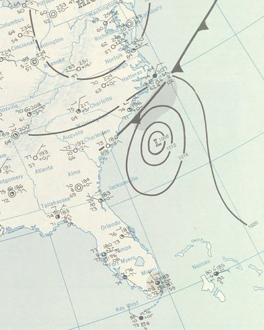
English: Surface analysis for July 8, 1959, specifically the area around Hurricane Cindy. |
|||
| Date | ||||
| Source | http://docs.lib.noaa.gov/rescue/dwm/data_rescue_daily_weather_maps.html | |||
| Author | U.S. Department of Commerce, Weather Bureau | |||
| Permission ( Reusing this file) |
|

Licensing
This image is in the
public domain because it contains materials that originally came from the U.S.
National Oceanic and Atmospheric Administration, taken or made as part of an employee's official duties.
|
File history
Click on a date/time to view the file as it appeared at that time.
| Date/Time | Thumbnail | Dimensions | User | Comment | |
|---|---|---|---|---|---|
| current | 21:17, 2 November 2011 |
| 1,145 × 1,432 (2.18 MB) | Inks.LWC | Cropped out labels |
| 21:09, 2 November 2011 |
 | 1,283 × 1,432 (2.37 MB) | Inks.LWC | Cropped so it's less tall | |
| 19:04, 2 November 2011 |
 | 1,283 × 2,068 (3.3 MB) | Inks.LWC | {{Information |Description ={{en|1=Surface analysis for July 8, 1959, specifically the area around Hurricane Cindy.}} |Source =http://docs.lib.noaa.gov/rescue/dwm/data_rescue_daily_weather_maps.html |Author =U.S. Department of Commerce, |
File usage
The following pages on the English Wikipedia use this file (pages on other projects are not listed):
Global file usage
The following other wikis use this file:
- Usage on pt.wikipedia.org