
Size of this PNG preview of this SVG file:
386 × 599 pixels. Other resolutions:
154 × 240 pixels |
309 × 480 pixels |
494 × 768 pixels |
659 × 1,024 pixels |
1,319 × 2,048 pixels |
494 × 767 pixels.
Original file (SVG file, nominally 494 × 767 pixels, file size: 14 KB)
| This is a file from the
Wikimedia Commons. Information from its
description page there is shown below. Commons is a freely licensed media file repository. You can help. |
-1.svg)
Summary
| Description |
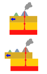
English: Illustration of how hotspot volcanoes work.
日本語: ホットスポットの模式図。青矢印がリソスフェアの移動方向。
Norsk bokmål: Søylestrøm |
| Date | |
| Source |
Own work based on:
|
| Author | Los688 |
| Permission ( Reusing this file) |
PD-self |
Licensing
| I, the copyright holder of this work, release this work into the
public domain. This applies worldwide. In some countries this may not be legally possible; if so: I grant anyone the right to use this work for any purpose, without any conditions, unless such conditions are required by law. |
File history
Click on a date/time to view the file as it appeared at that time.
| Date/Time | Thumbnail | Dimensions | User | Comment | |
|---|---|---|---|---|---|
| current | 06:52, 27 September 2008 |
| 494 × 767 (14 KB) | Los688 | |
| 14:06, 25 August 2008 |
 | 494 × 767 (12 KB) | Los688 | m | |
| 11:18, 24 August 2008 |
 | 494 × 767 (11 KB) | Los688 | ro | |
| 11:14, 24 August 2008 |
 | 731 × 421 (12 KB) | Los688 | {{Information |Description={{en|1=Hotspot.Geology.}} {{ja|1=ホットスポットの模式図。青矢印が地殻の移動方向。}} |Source=myown work |Author=Los688 |Date=24-Aug-2008 |Permission=PD-self |other_versions= }} <!--{{ImageUpload|full}}--> |
File usage
The following pages on the English Wikipedia use this file (pages on other projects are not listed):
Global file usage
The following other wikis use this file:
- Usage on af.wikipedia.org
- Usage on de.wikipedia.org
- Usage on eo.wikipedia.org
- Usage on es.wikipedia.org
- Usage on eu.wikipedia.org
- Usage on gl.wikipedia.org
- Usage on he.wikipedia.org
- Usage on hu.wikipedia.org
- Usage on id.wikipedia.org
- Usage on is.wikipedia.org
- Usage on it.wikibooks.org
- Usage on it.wikiversity.org
- Usage on ja.wikipedia.org
- Usage on ja.wikibooks.org
- Usage on ka.wikipedia.org
- Usage on ko.wikipedia.org
- Usage on mk.wikipedia.org
- Usage on ml.wikipedia.org
- Usage on nl.wikipedia.org
- Usage on nn.wikipedia.org
- Usage on no.wikipedia.org
- Usage on pl.wikipedia.org
- Usage on ro.wikipedia.org
- Usage on ru.wikipedia.org
- Usage on simple.wikipedia.org
- Usage on sr.wikipedia.org
- Usage on sv.wikipedia.org
- Usage on th.wikipedia.org
- Usage on tl.wikipedia.org
- Usage on tr.wikipedia.org
- Usage on uk.wikipedia.org
- Usage on vi.wikipedia.org
- Usage on zh-yue.wikipedia.org
-1.svg)