
Size of this preview:
800 × 428 pixels. Other resolutions:
320 × 171 pixels |
640 × 342 pixels |
1,396 × 746 pixels.
Original file (1,396 × 746 pixels, file size: 168 KB, MIME type: image/jpeg)
| This is a file from the
Wikimedia Commons. Information from its
description page there is shown below. Commons is a freely licensed media file repository. You can help. |
This is a photo of a monument indexed in the Spanish heritage register of Bienes de Interés Cultural under the reference 4374. |
| Description |
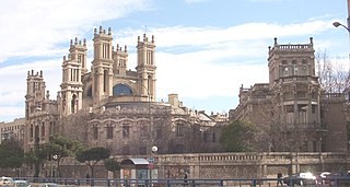
English: View, from the north-west angle, of
Maudes Hospital, at 18 Calle de Raimundo Fernández Villaverde (street) in
Chamberí district in
Madrid (
Spain). It's a former hospital, projected in 1908 by architects
Antonio Palacios and Joaquín Otamendi Machimbarrena, and built between 1909 and 1916.
Español: Vista, desde el ángulo noroeste, del
Hospital de Maudes, en el nº 18 de la Calle de Raimundo Fernández Villaverde (
distrito de Chamberí) de
Madrid (
España). Es un antiguo hospital, proyectado en 1908 por los arquitectos
Antonio Palacios y Joaquín Otamendi Machimbarrena, y construido entre 1909 y 1916. |
||||||||
| Date | |||||||||
| Source | Own work | ||||||||
| Author | Luis García ( Zaqarbal) | ||||||||
| Permission ( Reusing this file) |
I, the copyright holder of this work, hereby publish it under the following licenses:
You may select the license of your choice. |
||||||||
| Other versions |
_02.jpg) |

_01.jpg)
| Object location |
| View this and other nearby images on: OpenStreetMap |
|
|---|
_01.jpg¶ms=040.445936_N_-003.701125_E_globe:Earth_class:object_type:landmark_region:ES_&language=en)
File history
Click on a date/time to view the file as it appeared at that time.
| Date/Time | Thumbnail | Dimensions | User | Comment | |
|---|---|---|---|---|---|
| current | 06:12, 29 December 2005 |
| 1,396 × 746 (168 KB) | Zaqarbal | Taken by/Tomada por Zaqarbal, 28-XII-2005, {{GFDL}}. |
File usage
The following pages on the English Wikipedia use this file (pages on other projects are not listed):
Global file usage
The following other wikis use this file:
- Usage on bcl.wikipedia.org
- Usage on ca.wikipedia.org
- Usage on es.wikipedia.org
- Usage on gl.wikipedia.org
- Usage on ja.wikipedia.org
- Usage on pl.wikipedia.org
- Usage on qu.wikipedia.org
- Usage on roa-tara.wikipedia.org
- Usage on sv.wikipedia.org
- Usage on th.wikipedia.org
- Usage on tl.wikipedia.org
_01.jpg)