
Size of this preview:
756 × 599 pixels. Other resolutions:
303 × 240 pixels |
606 × 480 pixels |
969 × 768 pixels |
1,280 × 1,015 pixels |
2,560 × 2,029 pixels |
3,000 × 2,378 pixels.
Original file (3,000 × 2,378 pixels, file size: 2.28 MB, MIME type: image/png)
| This is a file from the
Wikimedia Commons. Information from its
description page there is shown below. Commons is a freely licensed media file repository. You can help. |
Summary
| Description |
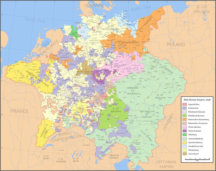
Map of the Holy Roman Empire in 1648, after the Peace of Westphalia. This is a png version of the original svg. Uses the colour scheme of Wikipedia:WikiProject Maps and the free to use Color Brewer.
Ecclesiastical lands
Swedish after 1648
|
| Date | |
| Source |
Made from the public domain map from the Perry-Castañeda Library Map Collection at the University of Texas |
| Author | Astrokey44 |
| Permission ( Reusing this file) |
self made |
| Other versions |
|
Licensing

|
Permission is granted to copy, distribute and/or modify this document under the terms of the GNU Free Documentation License, Version 1.2 or any later version published by the Free Software Foundation; with no Invariant Sections, no Front-Cover Texts, and no Back-Cover Texts. A copy of the license is included in the section entitled GNU Free Documentation License. |
| This file is licensed under the Creative Commons Attribution-Share Alike 3.0 Unported license. | ||
| ||
| This licensing tag was added to this file as part of the GFDL licensing update. |
File history
Click on a date/time to view the file as it appeared at that time.
| Date/Time | Thumbnail | Dimensions | User | Comment | |
|---|---|---|---|---|---|
| current | 18:02, 8 October 2010 |
| 3,000 × 2,378 (2.28 MB) | Joostik | Barony of Ravenstein as part of Cleves |
| 06:26, 28 April 2007 |
 | 3,000 × 2,378 (2.92 MB) | Roke~commonswiki | swiss cantons | |
| 15:31, 20 April 2007 |
 | 3,000 × 2,378 (2.88 MB) | Roke~commonswiki | ||
| 03:01, 18 April 2007 |
 | 3,000 × 2,378 (3 MB) | Roke~commonswiki | ||
| 12:13, 15 March 2007 |
 | 1,973 × 1,513 (1.76 MB) | Roke~commonswiki | fix anhalt | |
| 02:02, 29 January 2007 |
 | 1,973 × 1,513 (1.75 MB) | Roke~commonswiki | {{Information |Description=Map of the Holy Roman Empire in 1648, after the Peace of Westphalia. This is a png version of the original svg. {{legend|#aa0000|[[w:Imperial cit |
File usage
The following pages on the English Wikipedia use this file (pages on other projects are not listed):
Global file usage
The following other wikis use this file:
- Usage on bn.wikipedia.org
- Usage on da.wikipedia.org
- Usage on de.wikipedia.org
- Usage on en.wiktionary.org
- Usage on fi.wikipedia.org
- Usage on hu.wikipedia.org
- Usage on ja.wikipedia.org
- Usage on no.wikipedia.org
- Usage on ru.wiktionary.org
- Heiliges Römisches Reich Deutscher Nation
- Holy Roman Empire
- الإمبراطورية الرومانية المقدسة
- Սրբազան Հռոմեական կայսրություն
- Свяшчэнная Рымская імперыя
- Свещена Римска империя
- 神聖羅馬帝國
- 神圣罗马帝国
- Svatá říše římská
- Heilige Roomse Rijk
- Pyhä saksalais-roomalainen keisarikunta
- Saint-Empire romain germanique
- Sacro Imperio Romano
- საღვთო რომის იმპერია
- Heiliges Römisches Reich
- Αγία Ρωμαϊκή Αυτοκρατορία
- האימפריה הרומית הקדושה
- पवित्र रोम साम्राज्य
- Német-római Birodalom
- Heilaga rómverska ríkið
- Impireacht Naofa na Róimhe
- Naomh-Impireacht Rómhánach
- Sacro Romano Impero
- 神聖ローマ帝国
- 신성 로마 제국
- Sacrum Romanum Imperium
- Свето римско царство
- امپراتوری مقدس روم
- Święte Cesarstwo Rzymskie Narodu Niemieckiego
- Sacro Império Romano-Germânico
- Свето Римско Царство
- Sveto Rimsko Carstvo
- Rímsko-nemecká ríša
- Sveto rimsko cesarstvo
- Sacro Imperio romano
- จักรวรรดิโรมันอันศักดิ์สิทธิ์
- Kutsal Roma İmparatorluğu
- Священна Римська імперія
- Usage on tr.wikipedia.org
- Usage on ur.wikipedia.org