No higher resolution available.
Holkham_iron_age_fort.jpg (354 × 261 pixels, file size: 21 KB, MIME type: image/jpeg)
| This is a file from the
Wikimedia Commons. Information from its
description page there is shown below. Commons is a freely licensed media file repository. You can help. |
Summary
| Description |
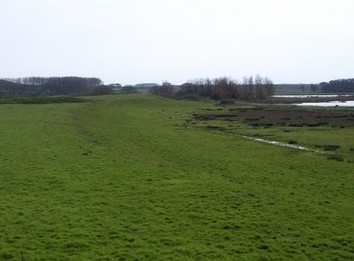
English: cropped version of Commons file Holkham_Iron_Age_Fort_from_the_Joe_Jordon_Bird_Hide_-_geograph.org.uk_-_443400.jpg
The iron age fort is viewed here from the Joe Jordon hide which is in a raised position overlooking both the fort and an area of water shown to the right, part of Holkham National Nature Reserve. An English Nature information board inside the hide states that "The raised area of humps and bumps you can see from the windows of the hide are the remains of an Iron Age (650 BC to AD 43) fort, known as Holkham Camp. It is one of only six sites of this type known in Norfolk." It also states that "The site was chosen because it was easy to defend at the time, being at the end of a sand spit that was isolated from the mainland by tidal salt marshes. The only access by dry land to the fort was from the seaward side, along the narrow raised sand spit that can be seen running from beneath the hide to the fort." |
| Date | |
| Source |
This file was derived from:
Holkham Iron Age Fort from the Joe Jordon Bird Hide - geograph.org.uk - 443400.jpg |
| Author | Nigel Stickells |
| Other versions |
|

| Camera location | | View this and other nearby images on: OpenStreetMap |
|
|---|
_heading:202.00&language=en)
| Object location | | View this and other nearby images on: OpenStreetMap |
|
|---|
_heading:202.00&language=en)
Licensing
This file is licensed under the
Creative Commons
Attribution-Share Alike 2.0 Generic license.
Attribution: Nigel Stickells
- You are free:
- to share – to copy, distribute and transmit the work
- to remix – to adapt the work
- Under the following conditions:
- attribution – You must give appropriate credit, provide a link to the license, and indicate if changes were made. You may do so in any reasonable manner, but not in any way that suggests the licensor endorses you or your use.
- share alike – If you remix, transform, or build upon the material, you must distribute your contributions under the same or compatible license as the original.
File history
Click on a date/time to view the file as it appeared at that time.
| Date/Time | Thumbnail | Dimensions | User | Comment | |
|---|---|---|---|---|---|
| current | 12:28, 20 August 2012 |
| 354 × 261 (21 KB) | Jimfbleak |
File usage
The following pages on the English Wikipedia use this file (pages on other projects are not listed):
Global file usage
The following other wikis use this file:
- Usage on www.wikidata.org