No higher resolution available.
Hazel.gif (304 × 272 pixels, file size: 30 KB, MIME type: image/gif, 0.2 s)
| This is a file from the
Wikimedia Commons. Information from its
description page there is shown below. Commons is a freely licensed media file repository. You can help. |
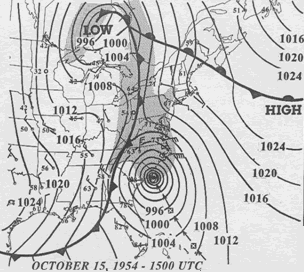
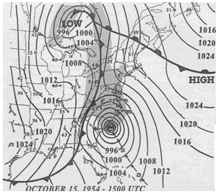
| Description | 15 UTC map of October 1954 showing Hurricane Hazel and the meteorological set-up. | |||
| Date | ||||
| Source | NOAA analysis created by Paul Kocin, of NOAA’s National Weather Service. It can be found at Environment Canada and at NOAA pages. This map is included in this article about Hazel by the Canadian Hurricane Center and this one by the National Weather Service Eastern Region Headquarters. | |||
| Author | NOAA | |||
| Permission ( Reusing this file) |
|
File history
Click on a date/time to view the file as it appeared at that time.
| Date/Time | Thumbnail | Dimensions | User | Comment | |
|---|---|---|---|---|---|
| current | 16:32, 13 March 2010 |
| 304 × 272 (30 KB) | Maxim | removed border |
| 07:23, 2 April 2007 |
 | 312 × 277 (32 KB) | Pierre cb | {{Hurricane auto track map|type=Hurricane|name=Hazel (1954)|source=NHC}} H {{Information |Description= 15 UTC map of October 1954 showing Hurricane Hazel and the meteorological set-up. |Source= [http://www.atl.e |
File usage
The following pages on the English Wikipedia use this file (pages on other projects are not listed):
Global file usage
The following other wikis use this file:
- Usage on eo.wikipedia.org
- Usage on es.wikipedia.org
- Usage on fa.wikipedia.org
- Usage on fr.wikipedia.org
- Usage on pt.wikipedia.org
- Usage on zh.wikipedia.org