
Size of this PNG preview of this SVG file:
728 × 600 pixels. Other resolutions:
291 × 240 pixels |
583 × 480 pixels |
932 × 768 pixels |
1,243 × 1,024 pixels |
2,485 × 2,048 pixels |
3,110 × 2,563 pixels.
Original file (SVG file, nominally 3,110 × 2,563 pixels, file size: 2.12 MB)
| This is a file from the
Wikimedia Commons. Information from its
description page there is shown below. Commons is a freely licensed media file repository. You can help. |
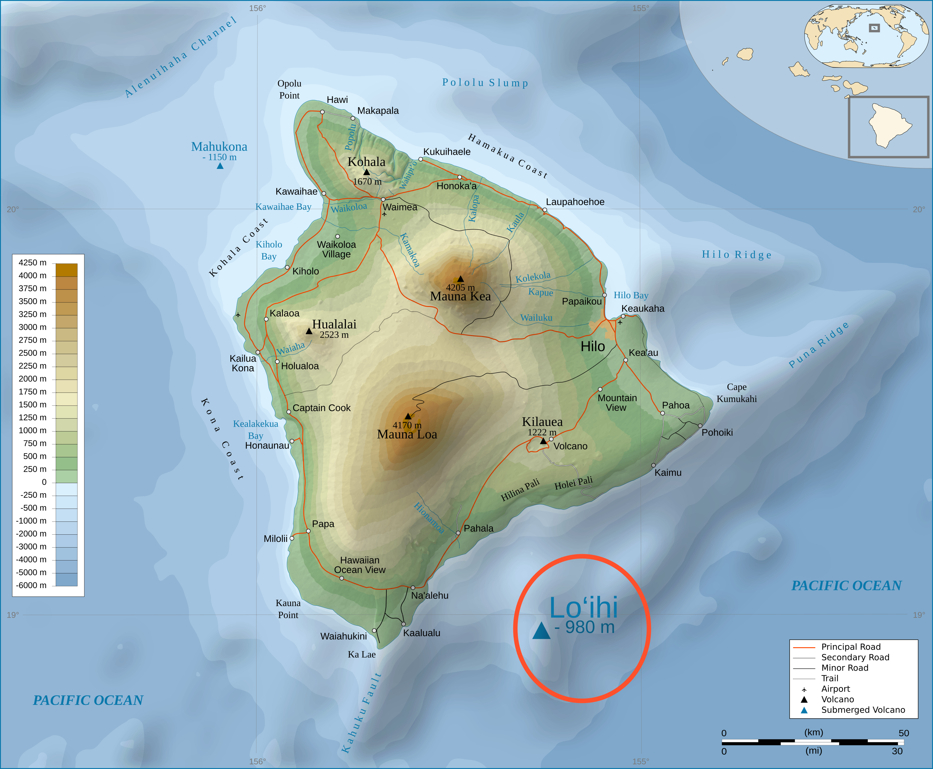
| Description | Topographic Map in english of the island of Hawaii with the Loihi Seamount highlighted. |
| Date | (UTC) |
| Source | |
| Author |
|
I, the copyright holder of this work, hereby publish it under the following license:
This file is licensed under the
Creative Commons
Attribution-Share Alike 3.0 Unported license.
- You are free:
- to share – to copy, distribute and transmit the work
- to remix – to adapt the work
- Under the following conditions:
- attribution – You must give appropriate credit, provide a link to the license, and indicate if changes were made. You may do so in any reasonable manner, but not in any way that suggests the licensor endorses you or your use.
- share alike – If you remix, transform, or build upon the material, you must distribute your contributions under the same or compatible license as the original.
Original upload log
This image is a derivative work of the following images:
-
File:Hawaii_Island_topographic_map-en.svg licensed with Cc-by-sa-3.0
- 2009-03-03T22:06:27Z Kmusser 3110x2563 (2223603 Bytes) {{Information |Description={{Topographic Map in english of the island of [[:en:Hawaii (Island)|Hawaii]].}} |Source=*[[:File:Hawaii_Island_topographic_map-fr.svg|]] |Date=2009-03-03 22:04 (UTC) |Author=*[[:File:Hawaii_Island_t
Uploaded with derivativeFX
File history
Click on a date/time to view the file as it appeared at that time.
| Date/Time | Thumbnail | Dimensions | User | Comment | |
|---|---|---|---|---|---|
| current | 23:15, 7 March 2009 |
| 3,110 × 2,563 (2.12 MB) | Resident Mario | recircling, increase of size not enough |
| 16:16, 5 March 2009 |
 | 3,110 × 2,563 (2.12 MB) | Kmusser | Increased size of Loihi label instead of circling | |
| 22:47, 3 March 2009 |
 | 3,110 × 2,563 (2.12 MB) | Kmusser | attempted legend fix | |
| 22:45, 3 March 2009 |
 | 3,110 × 2,563 (2.12 MB) | Kmusser | attempted legend fix | |
| 22:38, 3 March 2009 |
 | 3,110 × 2,563 (2.12 MB) | Kmusser | attempted legend fix | |
| 22:12, 3 March 2009 |
 | 3,110 × 2,563 (2.12 MB) | Kmusser | {{Information |Description=Topographic Map in english of the island of Hawaii with the Loihi Seamount highlighted. |Source=* File:Hawaii_Island_topographic_map-en.svg |Date=2009-03-03 22:11 (UTC) |Author=*[[:File:Hawaii_Island |
File usage
The following pages on the English Wikipedia use this file (pages on other projects are not listed):
Global file usage
The following other wikis use this file:
- Usage on ca.wikipedia.org
- Usage on de.wikipedia.org
- Usage on fa.wikipedia.org
- Usage on fi.wikipedia.org
- Usage on id.wikipedia.org
- Usage on it.wikipedia.org
- Usage on ja.wikipedia.org
- Usage on min.wikipedia.org
- Usage on no.wikipedia.org
- Usage on os.wikipedia.org
- Usage on pl.wikipedia.org
- Usage on simple.wikipedia.org
- Usage on sv.wikipedia.org
- Usage on tr.wikipedia.org
- Usage on uk.wikipedia.org
- Usage on zh.wikipedia.org