
Size of this preview:
800 × 593 pixels. Other resolutions:
320 × 237 pixels |
640 × 475 pixels |
1,024 × 760 pixels |
1,280 × 949 pixels |
2,560 × 1,899 pixels |
3,137 × 2,327 pixels.
Original file (3,137 × 2,327 pixels, file size: 2.22 MB, MIME type: image/jpeg)
| This is a file from the
Wikimedia Commons. Information from its
description page there is shown below. Commons is a freely licensed media file repository. You can help. |
Summary
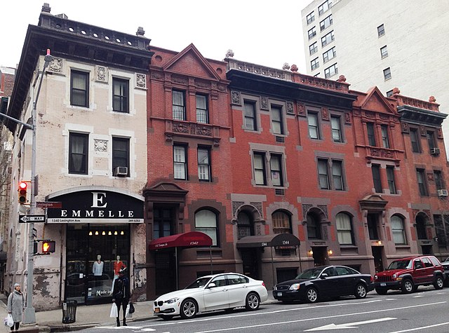
| Description | The Hardenberg/Rhinelander Historic District is a small historic district in the Carnegie Hill neighborhood of the Upper East Side of Manhattan, New York City created by the New York City Landmarks Preservation Commission in 1998. It consists of six Northern Renaissance Revival buildings along Lexington Avenue between 89th and 90th Streets constructed in 1888-89, and one on East 89th Street. Six of the brick, brownstone and terra cotta buildings are rowhouses, and one is an apartment building, referred to as "French Flats" at the time. The name of the district derives from the architect, Henry J. Hardenbergh, and the owner and developer of the properties, the Estate of William C. Rhinelander. The Rhinelanders were a prominent family in the area. |
| Date | |
| Source | Own work |
| Author | Beyond My Ken |
| Camera location | | View this and other nearby images on: OpenStreetMap |
|
|---|
Licensing
I, the copyright holder of this work, hereby publish it under the following licenses:

|
Permission is granted to copy, distribute and/or modify this document under the terms of the GNU Free Documentation License, Version 1.2 or any later version published by the Free Software Foundation; with no Invariant Sections, no Front-Cover Texts, and no Back-Cover Texts. A copy of the license is included in the section entitled GNU Free Documentation License. |
This file is licensed under the
Creative Commons Attribution-Share Alike
4.0 International,
3.0 Unported,
2.5 Generic,
2.0 Generic and
1.0 Generic license.
- You are free:
- to share – to copy, distribute and transmit the work
- to remix – to adapt the work
- Under the following conditions:
- attribution – You must give appropriate credit, provide a link to the license, and indicate if changes were made. You may do so in any reasonable manner, but not in any way that suggests the licensor endorses you or your use.
- share alike – If you remix, transform, or build upon the material, you must distribute your contributions under the same or compatible license as the original.
You may select the license of your choice.
File history
Click on a date/time to view the file as it appeared at that time.
| Date/Time | Thumbnail | Dimensions | User | Comment | |
|---|---|---|---|---|---|
| current | 01:01, 24 June 2016 |
| 3,137 × 2,327 (2.22 MB) | Beyond My Ken | better shot |
| 23:21, 26 November 2012 |
 | 2,195 × 1,598 (762 KB) | Beyond My Ken | == {{int:filedesc}} == {{Information |Description= The ''' Hardenberg/Rhinelander Historic District''' is a small historic district in the Carnegie Hill neighborhood of the Upper East Side of Manhattan, N... |
File usage
The following pages on the English Wikipedia use this file (pages on other projects are not listed):
Global file usage
The following other wikis use this file:
- Usage on es.wikipedia.org
- Usage on ru.wikipedia.org
- Usage on www.wikidata.org