Size of this preview:
783 × 600 pixels. Other resolutions:
313 × 240 pixels |
627 × 480 pixels |
1,002 × 768 pixels |
1,215 × 931 pixels.
Original file (1,215 × 931 pixels, file size: 77 KB, MIME type: image/gif)
| This is a file from the
Wikimedia Commons. Information from its
description page there is shown below. Commons is a freely licensed media file repository. You can help. |
Summary
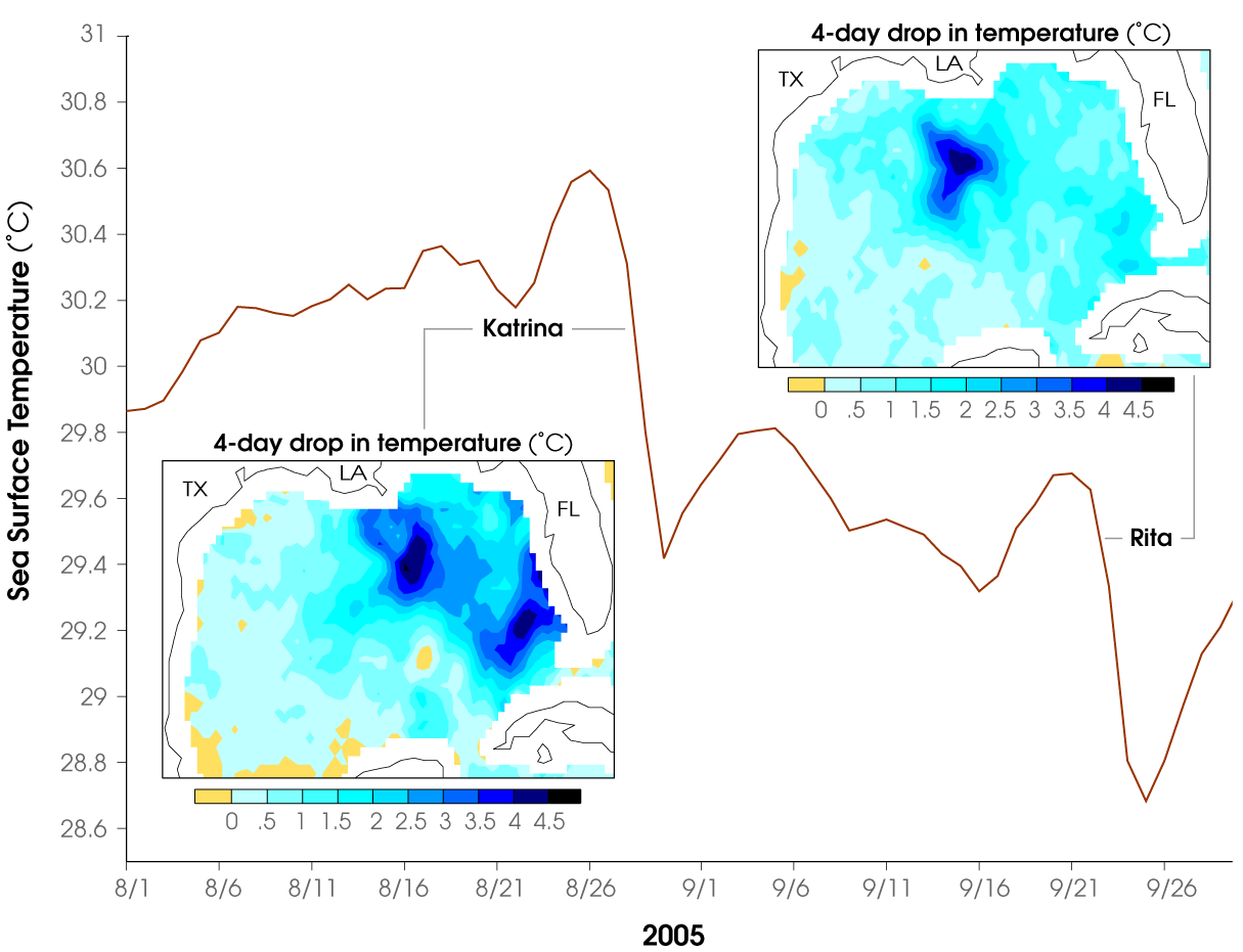
| Description | Chart showing drop in water temperature of the Gulf of Mexico as Hurricanes Katrina and Rita passed over. |
| Date | August–September, 2005 |
| Source | http://earthobservatory.nasa.gov/Newsroom/NewImages/images.php3?img_id=17164 |
| Author | Jenny Wu and Bill Lau, Climate and Radiation Branch, NASA-GSFC. |
| Permission ( Reusing this file) |
US government, public domain |

|
This chart image could be re-created using
vector graphics as an
SVG file. This has several advantages; see
Commons:Media for cleanup for more information. If an SVG form of this image is available, please upload it and afterwards replace this template with
{{
vector version available|new image name}}
.
It is recommended to name the SVG file “GulfMexTemps 2005Hurricanes.svg”—then the template Vector version available (or Vva) does not need the new image name parameter. |
Licensing
| This file is in the public domain in the United States because it was solely created by NASA. NASA copyright policy states that "NASA material is not protected by copyright unless noted". (See Template:PD-USGov, NASA copyright policy page or JPL Image Use Policy.) | ||
 |
Warnings:
|
File history
Click on a date/time to view the file as it appeared at that time.
| Date/Time | Thumbnail | Dimensions | User | Comment | |
|---|---|---|---|---|---|
| current | 23:18, 26 April 2006 |
| 1,215 × 931 (77 KB) | Holly Cheng | {{Information | Description=Chart showing drop in water temperature of the Gulf of Mexico as Hurricanes Katrina and Rita passed over. | Source=http://earthobservatory.nasa.gov/Newsroom/NewImages/images.php3?img_id= |
File usage
The following pages on the English Wikipedia use this file (pages on other projects are not listed):
Global file usage
The following other wikis use this file:
- Usage on ast.wikipedia.org
- Usage on ba.wikipedia.org
- Usage on es.wikipedia.org
- Usage on fr.wikipedia.org
- Usage on hi.wikipedia.org
- Usage on nn.wikipedia.org
- Usage on no.wikipedia.org
- Usage on ru.wikipedia.org
- Usage on sh.wikipedia.org
- Usage on sr.wikipedia.org
- Usage on th.wikipedia.org
- Usage on tl.wikipedia.org
- Usage on uk.wikipedia.org
- Usage on uz.wikipedia.org