
Size of this PNG preview of this SVG file:
800 × 600 pixels. Other resolutions:
320 × 240 pixels |
640 × 480 pixels |
1,024 × 768 pixels |
1,280 × 960 pixels |
2,560 × 1,920 pixels |
1,000 × 750 pixels.
Original file (SVG file, nominally 1,000 × 750 pixels, file size: 4.76 MB)
| This is a file from the
Wikimedia Commons. Information from its
description page there is shown below. Commons is a freely licensed media file repository. You can help. |
Summary
| Description |
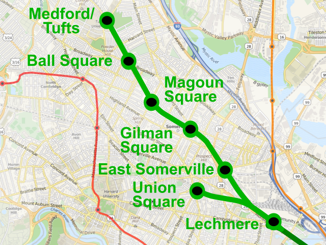
English: Map of the Green Line Extension into Somerville and Medford. (Note: PNG map of background was used to keep filesize reasonable. For large and scalable applications, I recommend downloading the vector map directly from OpenStreetMap.) |
| Date | |
| Source | Own work |
| Author | Pi.1415926535 |
| Permission ( Reusing this file) |
Includes background map (CC-BY-SA 2.0) from OpenStreetMap, by OpenStreetMap contributors |
| SVG development |
Licensing
I, the copyright holder of this work, hereby publish it under the following licenses:
This file is licensed under the
Creative Commons
Attribution-Share Alike 3.0 Unported license.
- You are free:
- to share – to copy, distribute and transmit the work
- to remix – to adapt the work
- Under the following conditions:
- attribution – You must give appropriate credit, provide a link to the license, and indicate if changes were made. You may do so in any reasonable manner, but not in any way that suggests the licensor endorses you or your use.
- share alike – If you remix, transform, or build upon the material, you must distribute your contributions under the same or compatible license as the original.

|
Permission is granted to copy, distribute and/or modify this document under the terms of the GNU Free Documentation License, Version 1.2 or any later version published by the Free Software Foundation; with no Invariant Sections, no Front-Cover Texts, and no Back-Cover Texts. A copy of the license is included in the section entitled GNU Free Documentation License. |
You may select the license of your choice.
File history
Click on a date/time to view the file as it appeared at that time.
| Date/Time | Thumbnail | Dimensions | User | Comment | |
|---|---|---|---|---|---|
| current | 06:26, 3 January 2020 |
| 1,000 × 750 (4.76 MB) | Pi.1415926535 | update with new name |
| 15:57, 9 December 2016 |
 | 1,000 × 750 (4.76 MB) | Pi.1415926535 | fix text | |
| 15:54, 9 December 2016 |
 | 1,000 × 750 (4.69 MB) | Pi.1415926535 | Update for new station names | |
| 21:29, 28 September 2013 |
 | 1,080 × 720 (2.41 MB) | Pi.1415926535 | Fix branch widths; small background filesize; add existing subway lines | |
| 16:50, 23 May 2012 |
 | 1,280 × 720 (4.74 MB) | Pi.1415926535 | Text to path... | |
| 16:47, 23 May 2012 |
 | 1,280 × 720 (4.69 MB) | Pi.1415926535 | flowed text converted to text | |
| 16:45, 23 May 2012 |
 | 1,280 × 720 (4.69 MB) | Pi.1415926535 | {{Information |Description ={{en|1=Map of the Green Line Extension into Somerville and Medford}} |Source ={{own}} |Author = Pi.1415926535 |Date =23 May 2012 |Permission =Includes background map (CC... |
File usage
The following pages on the English Wikipedia use this file (pages on other projects are not listed):
Global file usage
The following other wikis use this file:
- Usage on id.wikipedia.org
- Usage on ja.wikipedia.org
- Usage on www.wikidata.org
- Usage on zh.wikipedia.org