Size of this preview:
600 × 600 pixels. Other resolutions:
240 × 240 pixels |
480 × 480 pixels |
768 × 768 pixels |
1,200 × 1,200 pixels.
Original file (1,200 × 1,200 pixels, file size: 570 KB, MIME type: image/png)
| This is a file from the
Wikimedia Commons. Information from its
description page there is shown below. Commons is a freely licensed media file repository. You can help. |
Summary
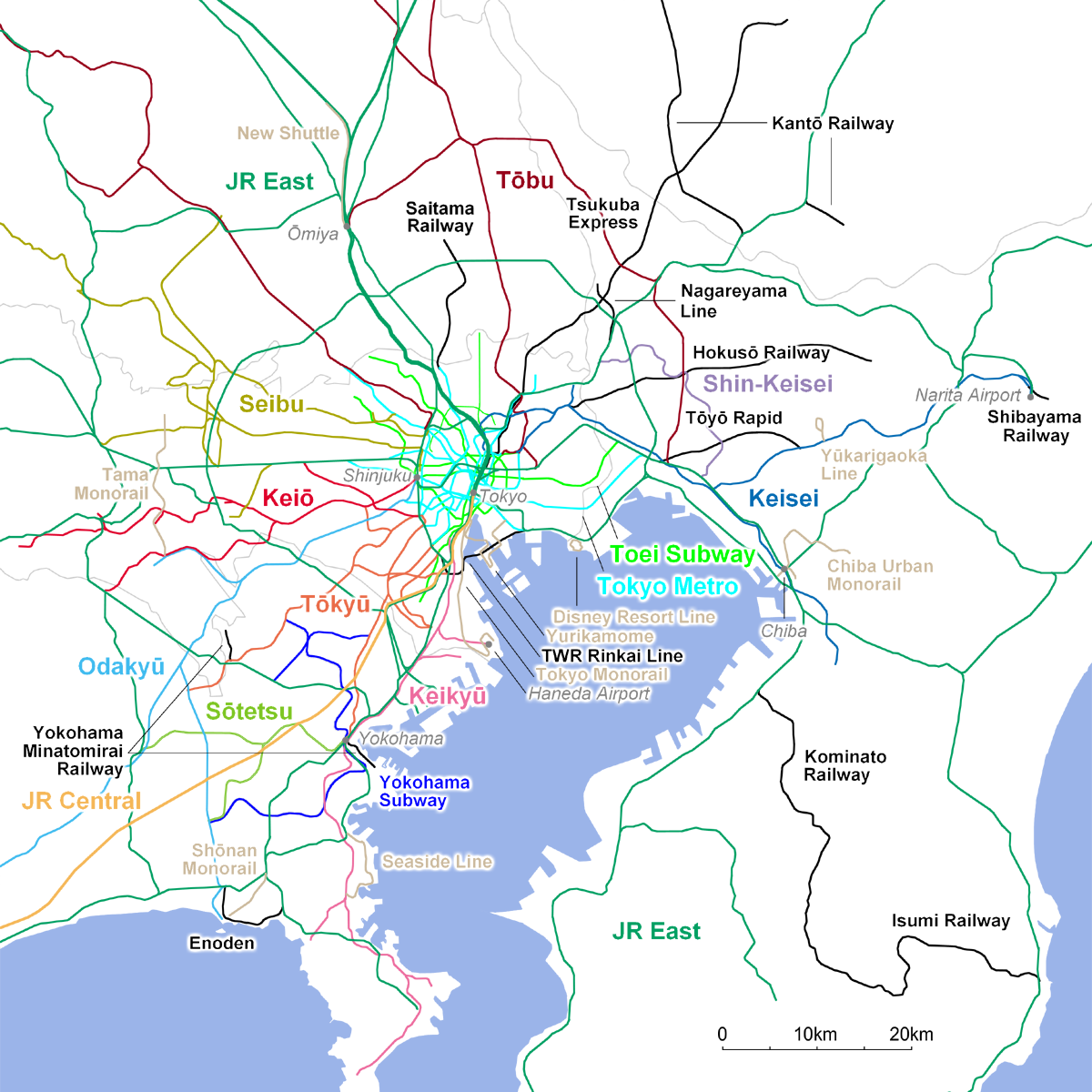
| Description | Approximate geographical representation of Greater Tokyo Area rail network. JR, Toei Subway, Major and Semi-major private railways (including Tokyo Metro) are in large font. These operators and Yokohama Subway are in different colors, while other lines are either black (conventional railways/metro) or brown (monorails/guideways). |
| Date | |
| Source | Own work (Own drawing) |
| Author | FML |
Licensing
I, the copyright holder of this work, hereby publish it under the following licenses:

|
Permission is granted to copy, distribute and/or modify this document under the terms of the GNU Free Documentation License, Version 1.2 or any later version published by the Free Software Foundation; with no Invariant Sections, no Front-Cover Texts, and no Back-Cover Texts. A copy of the license is included in the section entitled GNU Free Documentation License. |
This file is licensed under the
Creative Commons Attribution-Share Alike
3.0 Unported,
2.5 Generic,
2.0 Generic and
1.0 Generic license.
- You are free:
- to share – to copy, distribute and transmit the work
- to remix – to adapt the work
- Under the following conditions:
- attribution – You must give appropriate credit, provide a link to the license, and indicate if changes were made. You may do so in any reasonable manner, but not in any way that suggests the licensor endorses you or your use.
- share alike – If you remix, transform, or build upon the material, you must distribute your contributions under the same or compatible license as the original.
You may select the license of your choice.

|
This transport map image could be re-created using
vector graphics as an
SVG file. This has several advantages; see
Commons:Media for cleanup for more information. If an SVG form of this image is available, please upload it and afterwards replace this template with
{{
vector version available|new image name}}
.
It is recommended to name the SVG file “Greater Tokyo rail network.svg”—then the template Vector version available (or Vva) does not need the new image name parameter. |
File history
Click on a date/time to view the file as it appeared at that time.
| Date/Time | Thumbnail | Dimensions | User | Comment | |
|---|---|---|---|---|---|
| current | 11:53, 14 June 2008 |
| 1,200 × 1,200 (570 KB) | Kzaral~commonswiki | Fukutoshin Line opened |
| 22:43, 29 March 2008 |
 | 1,200 × 1,200 (572 KB) | Kzaral~commonswiki | Nippori-Toneri Liner and Yokohama Subway Green Line opened. | |
| 16:36, 18 August 2007 |
 | 1,200 × 1,200 (671 KB) | Kzaral~commonswiki | ||
| 16:16, 18 August 2007 |
 | 1,200 × 1,200 (723 KB) | Kzaral~commonswiki | {{Information |Description=Approximate geographical representation of Greater Tokyo Area rail network. JR, Toei Subway, Major and Semi-major private railways (including Tokyo Metro) are in large font. These operators and Yokohama Subway are in different c |
File usage
The following pages on the English Wikipedia use this file (pages on other projects are not listed):
Global file usage
The following other wikis use this file:
- Usage on de.wikipedia.org
- Usage on fa.wikipedia.org
- Usage on it.wikivoyage.org
- Usage on pl.wikipedia.org
- Usage on www.wikidata.org
- Usage on zh.wikipedia.org