No higher resolution available.
Grand_Canyon_Route_of_the_Atchison,_Topeka_&_Santa_Fe_Railway_1900-05.jpg (640 × 281 pixels, file size: 70 KB, MIME type: image/jpeg)
| This is a file from the
Wikimedia Commons. Information from its
description page there is shown below. Commons is a freely licensed media file repository. You can help. |
Summary
| Description |
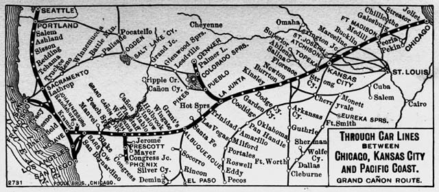
English: This reproduction of a cabinet card tacked to corkboard shows a map of the Grand Canyon Route of the Atchison, Topeka & Santa Fe Railway. The map title reads: "Through car lines between Chicago, Kansas City and Pacific Coast. Grand Canon Line." Other notes read: "2731. Poole Bros. Chicago." Between 1900 and 1905?
Western History/Genealogy Department, Denver Public Library. Call Number: CHS.J1745. "The Denver Public Library encourages use of these materials under the fair use clause of the 1976 copyright act. All images in this collection may be used for educational, scholarly purposes and private study. A credit line must be included with each item used." Image location: http://digital.denverlibrary.org/u?/p15330coll21,7963 |
| Source | |
| Author |
Licensing
This media file is in the
public domain in the
United States. This applies to U.S. works where the copyright has expired, often because its first
publication occurred prior to January 1, 1929, and if not then due to lack of notice or renewal. See
this page for further explanation.
|
 | |
 |
This image might not be in the public domain outside of the United States; this especially applies in the countries and areas that do not apply the
rule of the shorter term for US works, such as Canada, Mainland China (not Hong Kong or Macao), Germany, Mexico, and Switzerland. The creator and year of publication are essential information and must be provided. See
Wikipedia:Public domain and
Wikipedia:Copyrights for more details.
|
Original upload log
The original description page was
here. All following user names refer to en.wikipedia.
- 2005-06-14 21:12 Lordkinbote 640×281× (71849 bytes) This reproduction of a cabinet card tacked to corkboard shows a map of the Grand Canyon Route of the Atchison, Topeka & Santa Fe Railway. The map title reads: "Through car lines between Chicago, Kansas City and Pacific Coast. Grand Canon Line." Other note
File history
Click on a date/time to view the file as it appeared at that time.
| Date/Time | Thumbnail | Dimensions | User | Comment | |
|---|---|---|---|---|---|
| current | 16:04, 25 July 2011 |
| 640 × 281 (70 KB) | File Upload Bot (Magnus Manske) | {{BotMoveToCommons|en.wikipedia|year={{subst:CURRENTYEAR}}|month={{subst:CURRENTMONTHNAME}}|day={{subst:CURRENTDAY}}}} {{Information |Description={{en|This reproduction of a cabinet card tacked to corkboard shows a map of the Grand Canyon Route of the At |
File usage
The following pages on the English Wikipedia use this file (pages on other projects are not listed):
Global file usage
The following other wikis use this file:
- Usage on ar.wikipedia.org
- Usage on es.wikipedia.org
- Usage on fa.wikipedia.org
- Usage on hu.wikipedia.org
- Usage on ja.wikipedia.org
- Usage on www.wikidata.org