Size of this preview:
800 × 394 pixels. Other resolutions:
320 × 158 pixels |
640 × 315 pixels |
1,024 × 504 pixels |
1,280 × 630 pixels |
2,560 × 1,261 pixels |
5,000 × 2,462 pixels.
Original file (5,000 × 2,462 pixels, file size: 4.67 MB, MIME type: image/jpeg)
| This is a file from the
Wikimedia Commons. Information from its
description page there is shown below. Commons is a freely licensed media file repository. You can help. |
|
| This is a featured picture, which means that members of the community have identified it as one of the finest images on the English Wikipedia, adding significantly to its accompanying article. If you have a different image of similar quality, be sure to upload it using the proper free license tag, add it to a relevant article, and nominate it. |
|
| This image was selected as picture of the day on the English Wikipedia for May 9, 2015. |
| Description |
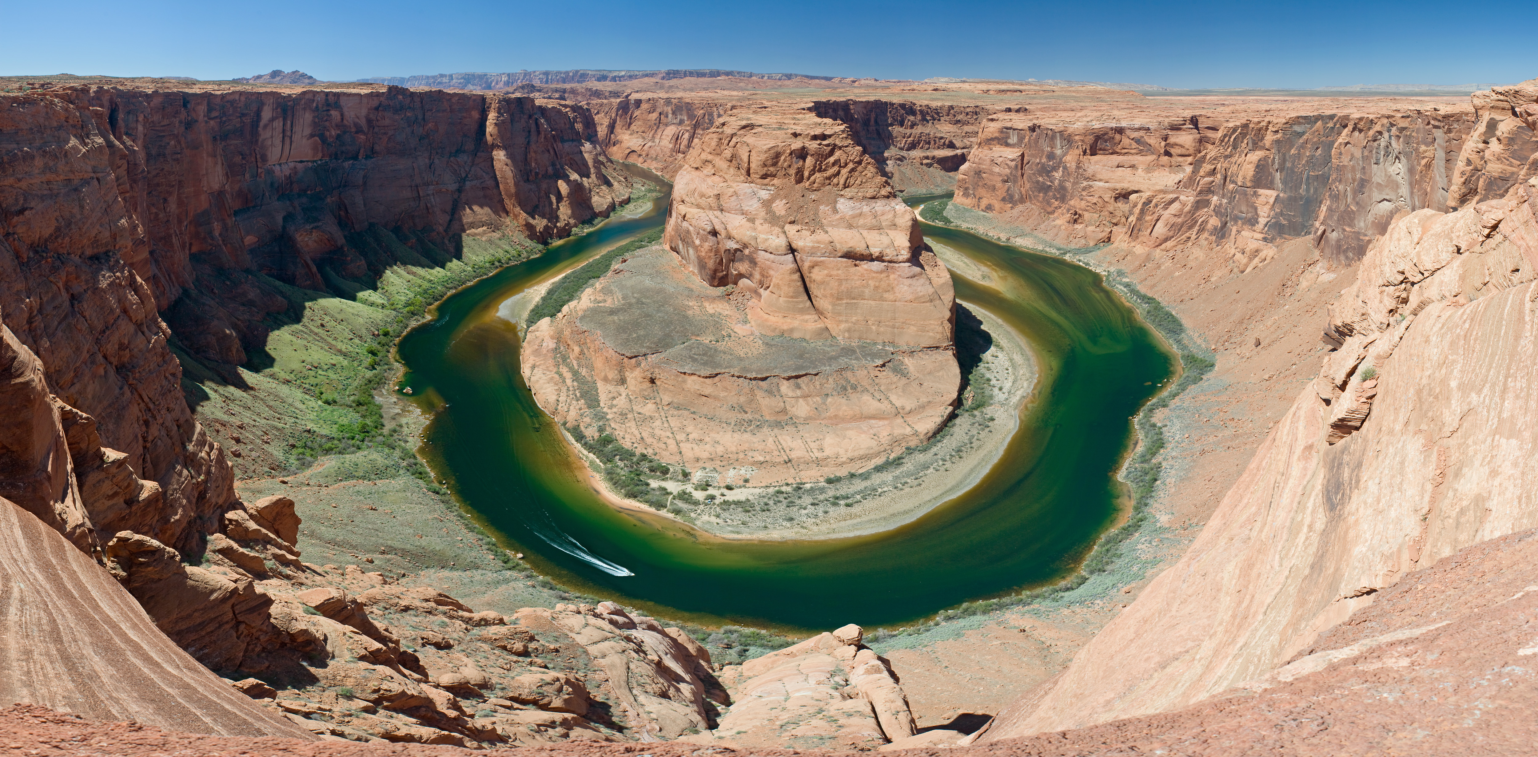
Deutsch: Der
Horseshoe Bend des Colorado Rivers befindet sich einige Kilometer südlich der Stadt Page in Arizona. Panorama zusammengesetzt aus 2x10 Hochformatbildern. Die Kamera wurde mit Hilfe eines Nodal Ninja
[1] Nodalpunktadapters (der auf einem Stativ befestigt war) rotiert. Alle Fotos wurden mit denselben Belichtungseinstellungen im RAW Format aufgezeichnet und mit denselben Einstellungen in einem RAW Konverter entwickelt. Zum Zusammenfügen wurde PTGUI
[2] verwendet.
English: The
Horseshoe Bend of the Colorado River is located a few kilometers south of the city of Page in Arizona. Panorama stitched from 2x10 portrait format images. The camera was rotated using a Nodal Ninja
[3] nodal point adapter which was mounted on a tripod. All photos were taken with the same exposure settings in RAW format and developed with exactly the same settings in a RAW converter. For stitching PTGUI
[4] was used.
Français : Le Horseshoe Bend de la riviere Colorado se trouve à quelques kilometres au sud de la ville de Page, en Arizona. Panorama construit à partir de 20 clichés format portrait assemblées avec [PTGUI
http://www.ptgui.com/].
|
| Date | |
| Source | Own work |
| Author | Christian Mehlführer, User:Chmehl |
| Permission ( Reusing this file) |
I, the copyright holder of this work, hereby publish it under the following license: This file is licensed under the
Creative Commons
Attribution 2.5 Generic license.
|
| Other versions |
Derivative works of this file:
Rule of Thirds-Grand Canyon Horse Shoe Bend MC.jpg:
|
| Camera location |
| View this and other nearby images on: OpenStreetMap |
|
|---|
|

This image was selected as
picture of the day on Wikimedia Commons for
1 July 2008. It was captioned as follows: Other languages:
Alemannisch: Dr Horseshoe Bend vom Colorado Rivers Bosanski: Okuka Potkovica rijeke Kolorado. Deutsch: Der Horseshoe Bend des
Colorado Rivers Français : Un méandre en forme de fer à cheval (The Horseshoe Bend), sur le fleuve
Colorado, aux
États-Unis. Galego: A formación Horseshoe Bend no río Colorado. Lietuvių: Kolorado upės pasagos išlinkimas Magyar: A „Patkókanyar” (Horseshoe Bend) a
Colorado-folyón Slovenčina: Meander rieky Colorado nazvaný Horsehoe Bend v
Arizone Беларуская: Лукавіна Хосшу-Бенд (Падкова) на рацэ Каларада (штат Арызона, ЗША). Русский: "Лошадиная Подкова" - изгиб на реке
Колорадо Українська: «Кінська Підкова» (The Horseshoe) — вигин річки
Колорадо. मराठी:
कॉलोराडो नदी घोड्याची नालच्या स्वरूपात العربية : إنحناء حدوة الفرس في نهر كولورادو. |
This image was selected as
picture of the day on Vietnamese Wikipedia.
|
File history
Click on a date/time to view the file as it appeared at that time.
| Date/Time | Thumbnail | Dimensions | User | Comment | |
|---|---|---|---|---|---|
| current | 12:29, 20 April 2008 |
| 5,000 × 2,462 (4.67 MB) | Chmehl | {{Location|36|52|44.7|N|111|30|37.1|W|type:landmark}} {{Information |Description= {{de|Der Horseshoe Bend des Colorado Rivers befindet sich einige Kilometer südlich der Stadt Page in Arizona. Panorama zusammengesetzt aus 2x10 Hochformatbildern.}} {{en|Th |
File usage
The following pages on the English Wikipedia use this file (pages on other projects are not listed):
- Dam removal
- Talk:Horseshoe Bend (Arizona)
- User:Daniel Mietchen/Science communication gallery
- User:Jj98/Random featured picture
- User:Jj98/Random featured picture/2
- User:Jokulhlaup/draftarticle24
- User:NavinS
- User talk:JJ Harrison/Archive6
- Wikipedia:Featured picture candidates/delist/2009
- Wikipedia:Featured picture candidates/delist/File:Horseshoe Bend 1 md.jpg
- Wikipedia:Featured pictures/Places/Landscapes
- Wikipedia:Featured pictures thumbs/04
- Wikipedia:Main Page history/2015 May 9
- Wikipedia:Picture of the day/May 2015
- Template:POTD/2015-05-09
- Portal:Arizona/Recognized content
- Portal:Arizona/Selected picture
- Portal:Arizona/Selected picture/3
- Portal:Rivers
- Portal:Rivers/Selected picture
- Portal:Rivers/Selected picture/2
- Portal:United States/Selected picture
- Portal:United States/Selected picture/10
Global file usage
The following other wikis use this file:
- Usage on af.wikipedia.org
- Usage on af.wiktionary.org
- Usage on als.wikipedia.org
- Usage on ar.wikipedia.org
- Usage on bn.wikipedia.org
- Usage on bo.wikipedia.org
- Usage on bs.wikipedia.org
- Usage on crh.wikipedia.org
- Usage on cv.wikipedia.org
- Usage on da.wikipedia.org
- Usage on de.wikipedia.org
- Portal Diskussion:Geographie/Bild des Monats
- Wikipedia:Exzellente Bilder/Landschaften
- Benutzer:Mayer Bruno/Bilder
- Wikipedia:Kandidaten für exzellente Bilder/Archiv2008/8
- Datei:Grand Canyon Horse Shoe Bend MC.jpg
- Wikipedia:Diskussionen über Bilder/Archiv/2008/Aug
- Benutzer:Der Wolf im Wald/Lieblingsbilder
- Benutzer:Reichland
- Wikipedia:Wiki Loves Monuments 2015/Deutschland/Ermunterungen und Tipps
- Usage on en.wikiquote.org
- Usage on en.wiktionary.org
- Usage on eo.wikipedia.org
- Usage on es.wikipedia.org
- Usage on fa.wikipedia.org
- ویکیپدیا:انتخاب نگاره هفته/بایگانی
- ویکیپدیا:انتخاب نگاره هفته/سال ۲۰۱۱
- خم نعل اسب
- ویکیپدیا:انتخاب نگاره هفته/سال ۲۰۱۱/هفته ۲۷
- ویکیپدیا:انتخاب نگاره هفته/سال ۲۰۱۱/هفته ۲۷/خم نعل اسب
- ویکیپدیا:نگارههای برگزیده/جاها/طبیعت
- ویکیپدیا:نگاره روز/مارس ۲۰۱۵
- الگو:نر/2015-03-30
- ویکیپدیا:گزیدن نگاره برگزیده/Grand Canyon Horse Shoe Bend MC.jpg
- الگو:نر محافظت شده/2015-03-30
- Usage on fr.wikipedia.org
- Usage on he.wikipedia.org
- Usage on hr.wikipedia.org
View more global usage of this file.