No higher resolution available.
Google_Maps_Beta.png (335 × 219 pixels, file size: 102 KB, MIME type: image/png)
Summary
| Description |
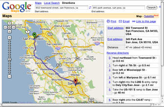
Screenshot of Google Maps in beta (2005) |
|---|---|
| Source | |
| Article | |
| Portion used |
Cropped top and bottom |
| Low resolution? |
Yes |
| Purpose of use |
Identification and critical commentary in the Google Maps article, a subject of public interest. |
| Replaceable? |
No |
| Fair use Fair use of copyrighted material in the context of Google Maps//en.wikipedia.org/wiki/File:Google_Maps_Beta.pngtrue | |
Licensing
 | This image is a screenshot of a
copyrighted web page, and the copyright for it is most likely held by the owner of the website. It may also contain
trademarked logos, which are likely not affiliated with Wikipedia. It is believed that the use of a limited number of such screenshots
| ||
| |||
File history
Click on a date/time to view the file as it appeared at that time.
| Date/Time | Thumbnail | Dimensions | User | Comment | |
|---|---|---|---|---|---|
| current | 14:55, 29 January 2019 |
| 335 × 219 (102 KB) | Tim42 ( talk | contribs) | {{Non-free use rationale |Article = Google Maps |Description = Screenshot of Google Maps in beta (2005) |Source = http://digital-archaeology.org/plotting-the-past/ |Portion = Cropped top and bottom |Low_resolution = Yes |Purpose = Identification and critical commentary in the Google Maps article, a subject of public interest. |Replaceability = No |other_information = }} |
You cannot overwrite this file.
File usage
The following pages on the English Wikipedia use this file (pages on other projects are not listed):