
Size of this preview:
800 × 576 pixels. Other resolutions:
320 × 230 pixels |
640 × 461 pixels |
1,024 × 737 pixels |
1,280 × 922 pixels |
1,600 × 1,152 pixels.
Original file (1,600 × 1,152 pixels, file size: 579 KB, MIME type: image/jpeg)
| This is a file from the
Wikimedia Commons. Information from its
description page there is shown below. Commons is a freely licensed media file repository. You can help. |
|
| This image appeared on Wikipedia's Main Page in the Did you know? column on 10 November 2018 (see archives). |
Summary
| Description |
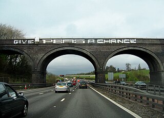
English: Give Peas A Chance. A well known bit of graffiti on the Amersham viaduct which now days crosses the M25 just north of the M40. I wonder whether the Victorian engineers who built it to carry a railway across a stream had a crystal ball since 70 years later the arches were wide enough for a three lane motorway to pass underneath.
This view is constantly changing as an extra lane is currently (Feb 2010) being added to the M25. See 334301 for a much earlier view as well as slightly different wording. Oh yes, and for the regular contributors to the site, this is my 14,000th photo to be uploaded! |
| Date | |
| Source | From geograph.org.uk |
| Author | Sebastian Ballard |
| Camera location | | View this and other nearby images on: OpenStreetMap |
|
|---|
_heading:0.00&language=en)
| Object location | | View this and other nearby images on: OpenStreetMap |
|
|---|
_heading:0.00&language=en)
Licensing

|
This image was taken from the
Geograph project collection. See
this photograph's page on the Geograph website for the photographer's contact details. The copyright on this image is owned by Sebastian Ballard and is licensed for reuse under the
Creative Commons Attribution-ShareAlike 2.0 license.
|
This file is licensed under the
Creative Commons
Attribution-Share Alike 2.0 Generic license.
Attribution: Sebastian Ballard
- You are free:
- to share – to copy, distribute and transmit the work
- to remix – to adapt the work
- Under the following conditions:
- attribution – You must give appropriate credit, provide a link to the license, and indicate if changes were made. You may do so in any reasonable manner, but not in any way that suggests the licensor endorses you or your use.
- share alike – If you remix, transform, or build upon the material, you must distribute your contributions under the same or compatible license as the original.
File history
Click on a date/time to view the file as it appeared at that time.
| Date/Time | Thumbnail | Dimensions | User | Comment | |
|---|---|---|---|---|---|
| current | 11:42, 21 September 2018 |
| 1,600 × 1,152 (579 KB) | Cnbrb | colour correction and minor crop to straighten level of bridge |
| 11:47, 5 March 2011 |
 | 1,600 × 1,152 (720 KB) | GeographBot | == {{int:filedesc}} == {{Information |description={{en|1=Give Peas A Chance A well known bit of graffiti on the Amersham viaduct which now days crosses the M25 just north of the M40. I wonder whether the Victorian engineers who built it to carry a railway |
File usage
The following pages on the English Wikipedia use this file (pages on other projects are not listed):
- Chalfont Viaduct
- James Charles Inglis
- List of railway bridges and viaducts in the United Kingdom
- M25 motorway
- User:Turini2/sandbox2
- Wikipedia:Did you know/Statistics/Monthly DYK pageview leaders/2018
- Wikipedia:Did you know/Statistics/Monthly DYK pageview leaders/2018/November
- Wikipedia:Main Page history/2018 November 9
- Wikipedia:Recent additions/2018/November
- Template:Did you know nominations/Chalfont Viaduct
- Portal:Trains/Did you know/Main page, 2018
Global file usage
The following other wikis use this file:
- Usage on es.wikipedia.org
- Usage on www.wikidata.org