
Size of this preview:
461 × 599 pixels. Other resolutions:
184 × 240 pixels |
369 × 480 pixels |
591 × 768 pixels |
787 × 1,024 pixels |
1,452 × 1,888 pixels.
Original file (1,452 × 1,888 pixels, file size: 509 KB, MIME type: image/jpeg)
| This is a file from the
Wikimedia Commons. Information from its
description page there is shown below. Commons is a freely licensed media file repository. You can help. |
Summary
| Description |
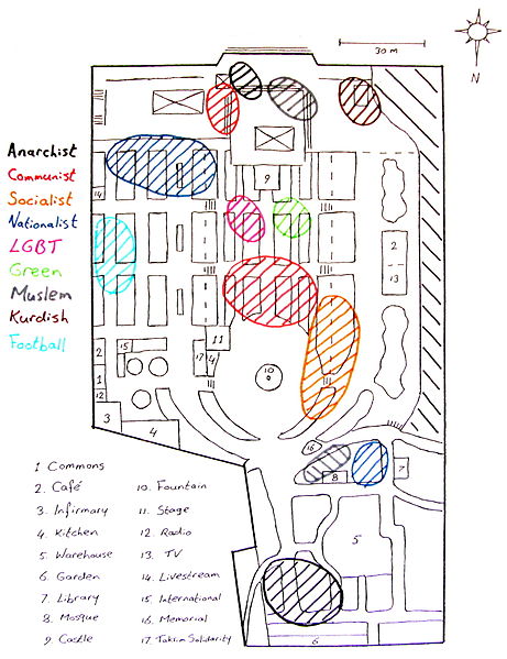
English: Hand drawn map of the Gezi park encampment |
| Date | |
| Source | This Cc-by-nc-sa licensed image has been taken from http://postvirtual.wordpress.com/2013/06/27/historical-atlas-of-gezi-park/ & minor modifications have been made. |
| Author | Anonymous |
Licensing
If you want to use this file commercially, you have to do this under the terms of the GFDL.
Otherwise, you are free to choose between the GFDL and CC-BY-NC-SA-2.0.

|
Permission is granted to copy, distribute and/or modify this document under the terms of the GNU Free Documentation License, Version 1.2 or any later version published by the Free Software Foundation; with no Invariant Sections, no Front-Cover Texts, and no Back-Cover Texts. A copy of the license is included in the section entitled GNU Free Documentation License. |
If this file is
eligible for relicensing, it may also be used under the
Creative Commons Attribution-ShareAlike 3.0 license. The relicensing status of this image has not yet been reviewed.
You can help.
|
This file is published under the following
Creative Commons license:
Attribution NonCommercial ShareAlike 2.0 |
File history
Click on a date/time to view the file as it appeared at that time.
| Date/Time | Thumbnail | Dimensions | User | Comment | |
|---|---|---|---|---|---|
| current | 02:03, 4 December 2013 |
| 1,452 × 1,888 (509 KB) | Gezginrocker | User created page with UploadWizard |
File usage
The following pages on the English Wikipedia use this file (pages on other projects are not listed):
Global file usage
The following other wikis use this file:
- Usage on ko.wikipedia.org
- Usage on mk.wikipedia.org