
Size of this preview:
575 × 600 pixels. Other resolutions:
230 × 240 pixels |
460 × 480 pixels |
951 × 992 pixels.
Original file (951 × 992 pixels, file size: 411 KB, MIME type: image/jpeg)
| This is a file from the
Wikimedia Commons. Information from its
description page there is shown below. Commons is a freely licensed media file repository. You can help. |
Summary
| Description |
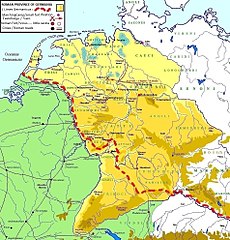
English: Map of the Roman province of Germania. Original map taken from Commons (File:Germania 7-9 Varo jpg.JPG). I have added data with my software. |
| Date | |
| Source | Own work |
| Author | ReMaps |
Licensing
I, the copyright holder of this work, hereby publish it under the following license:
This file is licensed under the
Creative Commons
Attribution-Share Alike 4.0 International license.
- You are free:
- to share – to copy, distribute and transmit the work
- to remix – to adapt the work
- Under the following conditions:
- attribution – You must give appropriate credit, provide a link to the license, and indicate if changes were made. You may do so in any reasonable manner, but not in any way that suggests the licensor endorses you or your use.
- share alike – If you remix, transform, or build upon the material, you must distribute your contributions under the same or compatible license as the original.
File history
Click on a date/time to view the file as it appeared at that time.
| Date/Time | Thumbnail | Dimensions | User | Comment | |
|---|---|---|---|---|---|
| current | 22:33, 29 July 2017 |
| 951 × 992 (411 KB) | ReMaps | added new castrum: "Tecelia" |
| 13:17, 28 July 2017 |
 | 951 × 992 (411 KB) | ReMaps | added "Bentumersiel" Roman camp/port | |
| 12:15, 24 July 2017 |
 | 951 × 992 (412 KB) | ReMaps | new castrum name: "Nida" | |
| 01:55, 23 July 2017 |
 | 951 × 992 (412 KB) | ReMaps | User created page with UploadWizard |
File usage
The following pages on the English Wikipedia use this file (pages on other projects are not listed):
Global file usage
The following other wikis use this file:
- Usage on ca.wikipedia.org
- Usage on cs.wikipedia.org
- Usage on de.wikipedia.org
- Usage on el.wikipedia.org
- Usage on eu.wikipedia.org
- Usage on fr.wikipedia.org
- Usage on gl.wikipedia.org
- Usage on lv.wikipedia.org
- Usage on mt.wikipedia.org
- Usage on ru.wikipedia.org
- Usage on sl.wikipedia.org
- Usage on sv.wikipedia.org
- Usage on uk.wikipedia.org
- Usage on vi.wikipedia.org
- Usage on zh.wikipedia.org