No higher resolution available.
Galveston_Bay_Landsat.jpg (368 × 464 pixels, file size: 33 KB, MIME type: image/jpeg)
| This is a file from the
Wikimedia Commons. Information from its
description page there is shown below. Commons is a freely licensed media file repository. You can help. |
Summary
| Description |
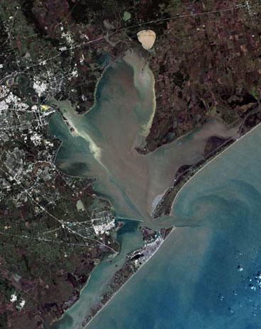
English:
Trinity Bay, (above), and
Galveston Bay, in southeast Texas.
|
| Date | |
| Source | Houston, Texas at the Wayback Machine |
| Author | United States Geological Survey |
| Other versions |

Licensing
This image is in the
public domain in the United States because it only contains materials that originally came from the
United States Geological Survey, an agency of the
United States Department of the Interior. For more information, see
the official USGS copyright policy.
|
Original upload log
Transferred from en.wikipedia to Commons by Ronhjones.
The original description page was
here. All following user names refer to en.wikipedia.
Upload date | User | Bytes | Dimensions | Comment
- 2009-10-15 04:15 (UTC) | Mcorazao | 23150 (bytes) | 247×322 | Author: United States Geological Service http://landsat.usgs.gov/gallery/detail/370/ This image is a clipped version of a satellite shot of the Houston area (clipping by M. Corazao)
File history
Click on a date/time to view the file as it appeared at that time.
| Date/Time | Thumbnail | Dimensions | User | Comment | |
|---|---|---|---|---|---|
| current | 10:12, 3 September 2017 |
| 368 × 464 (33 KB) | Ras67 | higher resolution, losslessly cropped from the original |
| 23:43, 2 January 2012 |
 | 247 × 322 (23 KB) | Ronhjones | (Original text) : Author: United States Geological Service http://landsat.usgs.gov/gallery/detail/370/ This image is a clipped version of a satellite shot of the Houston area (clipping by M. Corazao) |
File usage
The following pages on the English Wikipedia use this file (pages on other projects are not listed):
Global file usage
The following other wikis use this file:
- Usage on ca.wikipedia.org
- Usage on ceb.wikipedia.org
- Usage on de.wikipedia.org
- Usage on es.wikipedia.org
- Usage on fa.wikipedia.org
- Usage on fi.wikipedia.org
- Usage on fr.wikipedia.org
- Usage on he.wikipedia.org
- Usage on ja.wikipedia.org
- Usage on lt.wikipedia.org
- Usage on pt.wikipedia.org
- Usage on www.wikidata.org