
Size of this PNG preview of this SVG file:
794 × 600 pixels. Other resolutions:
318 × 240 pixels |
635 × 480 pixels |
1,017 × 768 pixels |
1,280 × 967 pixels |
2,560 × 1,934 pixels |
949 × 717 pixels.
Original file (SVG file, nominally 949 × 717 pixels, file size: 836 KB)
| This is a file from the
Wikimedia Commons. Information from its
description page there is shown below. Commons is a freely licensed media file repository. You can help. |
Summary
| Description |
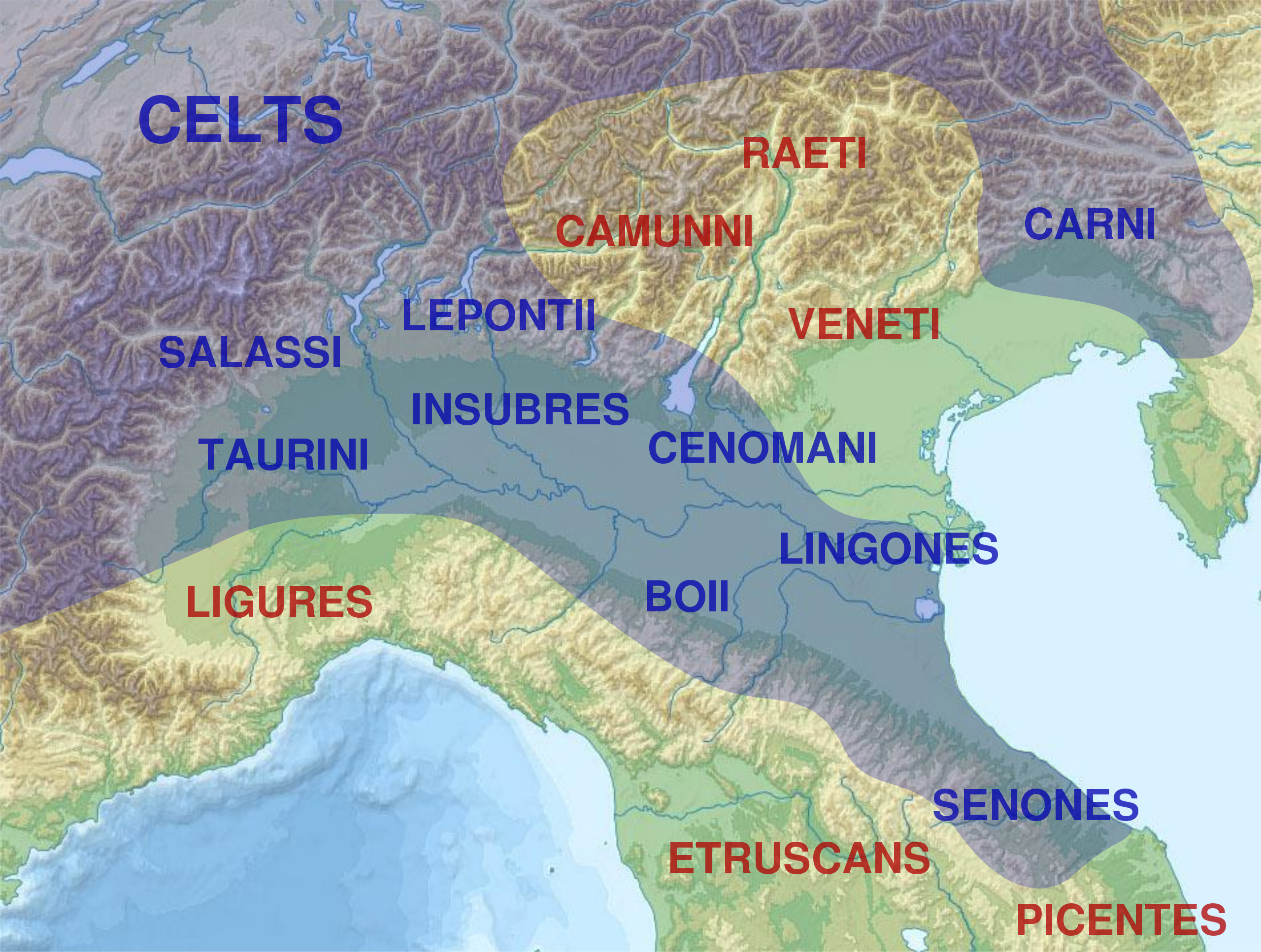
English: Map of
Cisalpine Gaul showing the approximate distributions of celtic populations in the area during the 4th and 3rd centuries BC.
Français : Carte de la
Gaule cisalpine et de l'emplacement approximatif des peuples qui l'habitaient et des peuples voisins.
Italiano: Distribuzione approssimata delle popolazioni della
Gallia Cisalpina.
Español: Mapa de
Galia Cisalpina mostrando las distribuciones aproximadas de las poblaciones celtas en el area durante los siglos IV y III antes de Cristo. |
||
| Date | |||
| Source |
This file was derived from: |
||
| Author | Nancy Todd - Derived work from Gallia_Cisalpina-fr.svg by Sémhur | ||
| Other versions | |||
| SVG | W3C-validity not checked.
|


Licensing
I, the copyright holder of this work, hereby publish it under the following licenses:
| Copyleft: This work of art is free; you can redistribute it and/or modify it according to terms of the Free Art License. You will find a specimen of this license on the Copyleft Attitude site as well as on other sites. |
This file is licensed under the
Creative Commons
Attribution-Share Alike 4.0 International license.
- You are free:
- to share – to copy, distribute and transmit the work
- to remix – to adapt the work
- Under the following conditions:
- attribution – You must give appropriate credit, provide a link to the license, and indicate if changes were made. You may do so in any reasonable manner, but not in any way that suggests the licensor endorses you or your use.
- share alike – If you remix, transform, or build upon the material, you must distribute your contributions under the same or compatible license as the original.
You may select the license of your choice.
| Camera location | | View this and other nearby images on: OpenStreetMap |
|
|---|
File history
Click on a date/time to view the file as it appeared at that time.
| Date/Time | Thumbnail | Dimensions | User | Comment | |
|---|---|---|---|---|---|
| current | 23:15, 17 July 2019 |
| 949 × 717 (836 KB) | Nancystodd | {{Information |description ={{en|1=Map of Cisalpine Gaul showing the approximate distributions of celtic populations in the area during the 4th and 3rd centuries BC.}} {{fr|1=Carte de la Gaule cisalpine et de l'emplacement approximatif des peuples qui l'habitaient et des peuples voisins.}} {{it|1=Distribuzione approssimata delle popolazioni della Gallia Cisalpina.}} {{es|1=Mapa de [[:es:Galia#Galia_Cisalpina|Galia Cisal... |
File usage
The following pages on the English Wikipedia use this file (pages on other projects are not listed):
Global file usage
The following other wikis use this file:
- Usage on ar.wikipedia.org
- Usage on br.wikipedia.org
- Usage on da.wikipedia.org
- Usage on el.wikipedia.org
- Usage on fr.wikipedia.org
- Usage on it.wikipedia.org
- Usage on lij.wikipedia.org
- Usage on sl.wikipedia.org
- Usage on tr.wikipedia.org
- Usage on ur.wikipedia.org