
Size of this preview:
800 × 519 pixels. Other resolutions:
320 × 208 pixels |
640 × 415 pixels |
1,024 × 665 pixels |
1,280 × 831 pixels |
1,758 × 1,141 pixels.
Original file (1,758 × 1,141 pixels, file size: 558 KB, MIME type: image/jpeg)
| This is a file from the
Wikimedia Commons. Information from its
description page there is shown below. Commons is a freely licensed media file repository. You can help. |
|
This is an image of a place or building that is listed on the
National Register of Historic Places in the
United States of America. Its reference number is
76000153. |
Summary
| Description |
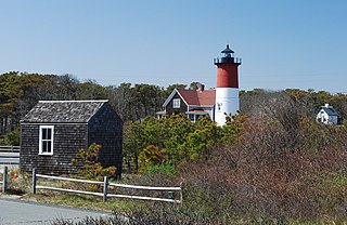
English: French Cable Hut, Eastham, Massachusetts. Site of transatlantic telegraph cable from Cape Cod, Massachusetts to France. |
| Date | |
| Source | Own work |
| Author | Marcbela (Marc N. Belanger) |
| Object location |
| View this and other nearby images on: OpenStreetMap |
|
|---|
Licensing
I, the copyright holder of this work, hereby publish it under the following license:
| This file is made available under the Creative Commons CC0 1.0 Universal Public Domain Dedication. | |
| The person who associated a work with this deed has dedicated the work to the
public domain by waiving all of their rights to the work worldwide under copyright law, including all related and neighboring rights, to the extent allowed by law. You can copy, modify, distribute and perform the work, even for commercial purposes, all without asking permission.
|
File history
Click on a date/time to view the file as it appeared at that time.
| Date/Time | Thumbnail | Dimensions | User | Comment | |
|---|---|---|---|---|---|
| current | 18:22, 8 May 2011 |
| 1,758 × 1,141 (558 KB) | Marcbela | {{Information |Description ={{en|1=French Cable Hut, Eastham, Massachusetts. Site of transatlantic telegraph cable from Cape Cod, Massachusetts to France.}} |Source ={{own}} |Author = Marcbela |Date =2010-04-2 |
File usage
The following pages on the English Wikipedia use this file (pages on other projects are not listed):
Global file usage
The following other wikis use this file:
- Usage on de.wikipedia.org
- Usage on www.wikidata.org