
Size of this preview:
764 × 600 pixels. Other resolutions:
306 × 240 pixels |
612 × 480 pixels |
979 × 768 pixels |
1,158 × 909 pixels.
Original file (1,158 × 909 pixels, file size: 1.03 MB, MIME type: image/png)
| This is a file from the
Wikimedia Commons. Information from its
description page there is shown below. Commons is a freely licensed media file repository. You can help. |
| Description |
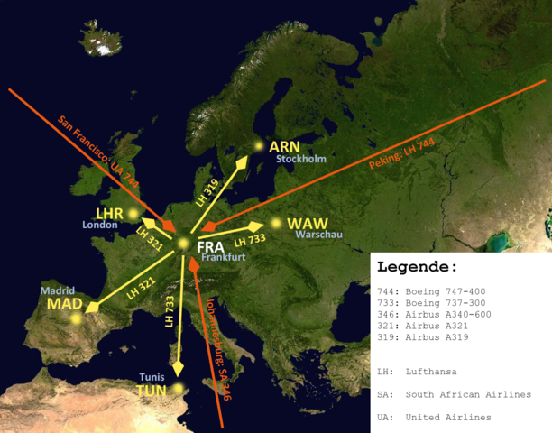
English: A map of Europe to show how an airport-hub is working. Using the example of Lufthansa based in FRA/EDDF. I added some common routes and common aircraft types, flying this route. For better understanding I added a caption. Deutsch: Eine Karte von Europa um das Prinzip eines Luftfahrdrehkreuzes zu verdeutlichen am Beispiel der Lufthansa in FRA/EDDF. Ich habe einige gewöhnliche Routen und die dazu passenden Flugzeugtypen eingetragen und eine Legende hinzugefügt. |
| Date | (UTC) |
| Source | |
| Author |
|
| This is a
retouched picture, which means that it has been digitally altered from its original version. Modifications: Fullcity names added. The original can be viewed here:
Frankfurt airport hub map.png:
|
I, the copyright holder of this work, hereby publish it under the following licenses:
This file is licensed under the
Creative Commons
Attribution-Share Alike 3.0 Unported license.
- You are free:
- to share – to copy, distribute and transmit the work
- to remix – to adapt the work
- Under the following conditions:
- attribution – You must give appropriate credit, provide a link to the license, and indicate if changes were made. You may do so in any reasonable manner, but not in any way that suggests the licensor endorses you or your use.
- share alike – If you remix, transform, or build upon the material, you must distribute your contributions under the same or compatible license as the original.
You may select the license of your choice.
Original upload log
This image is a derivative work of the following images:
-
Image:Frankfurt_airport_hub_map.png licensed with Cc-by-sa-3.0, Cc-by-sa-3.0
- 2008-12-10T17:12:37Z Upon a tree 1158x909 (1028574 Bytes) {{Information |Description={{en|1=A map of Europe to show how a airport-hub is working. Using the example of Lufthansa based in FRA/EDDF. I added some common routes and common aircraft types, flying this route. For bether und
Uploaded with derivativeFX
File history
Click on a date/time to view the file as it appeared at that time.
| Date/Time | Thumbnail | Dimensions | User | Comment | |
|---|---|---|---|---|---|
| current | 11:03, 11 December 2008 |
| 1,158 × 909 (1.03 MB) | Upon a tree | {{Information |Description={{en|1=A map of Europe to show how an airport-hub is working. Using the example of Lufthansa based in FRA/EDDF. I added some common routes and common aircraft types, flying this route. For bether understanding I added a caption. |
File usage
The following pages on the English Wikipedia use this file (pages on other projects are not listed):
Global file usage
The following other wikis use this file:
- Usage on af.wikipedia.org
- Usage on ar.wikipedia.org
- Usage on ast.wikipedia.org
- Usage on az.wikipedia.org
- Usage on bn.wikipedia.org
- Usage on ca.wikipedia.org
- Usage on cs.wikipedia.org
- Usage on da.wikipedia.org
- Usage on de.wikipedia.org
- Usage on eo.wikipedia.org
- Usage on es.wikipedia.org
- Usage on et.wikipedia.org
- Usage on fa.wikipedia.org
- Usage on fr.wikipedia.org
- Usage on hak.wikipedia.org
- Usage on hi.wikipedia.org
- Usage on id.wikipedia.org
- Usage on it.wikipedia.org
- Usage on ja.wikipedia.org
- Usage on kk.wikipedia.org
- Usage on ko.wikipedia.org
- Usage on nl.wikipedia.org
- Usage on pl.wikipedia.org
- Usage on simple.wikipedia.org
- Usage on sv.wikipedia.org
- Usage on tr.wikipedia.org
- Usage on zh.wikipedia.org