
Size of this PNG preview of this SVG file:
624 × 600 pixels. Other resolutions:
250 × 240 pixels |
499 × 480 pixels |
799 × 768 pixels |
1,066 × 1,024 pixels |
2,131 × 2,048 pixels |
2,000 × 1,922 pixels.
Original file (SVG file, nominally 2,000 × 1,922 pixels, file size: 4.6 MB)
| This is a file from the
Wikimedia Commons. Information from its
description page there is shown below. Commons is a freely licensed media file repository. You can help. |
Summary
| Description |
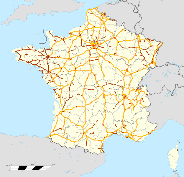
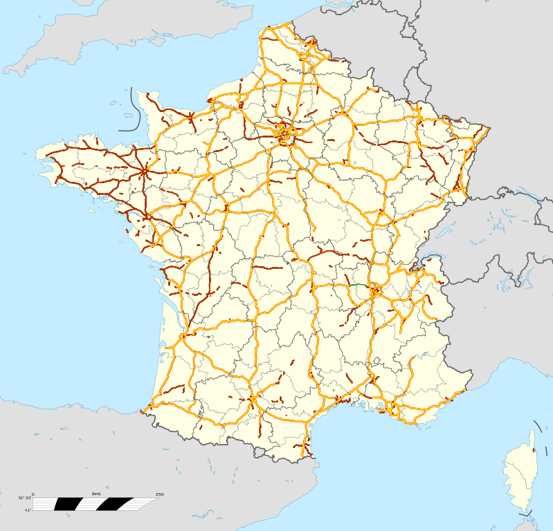
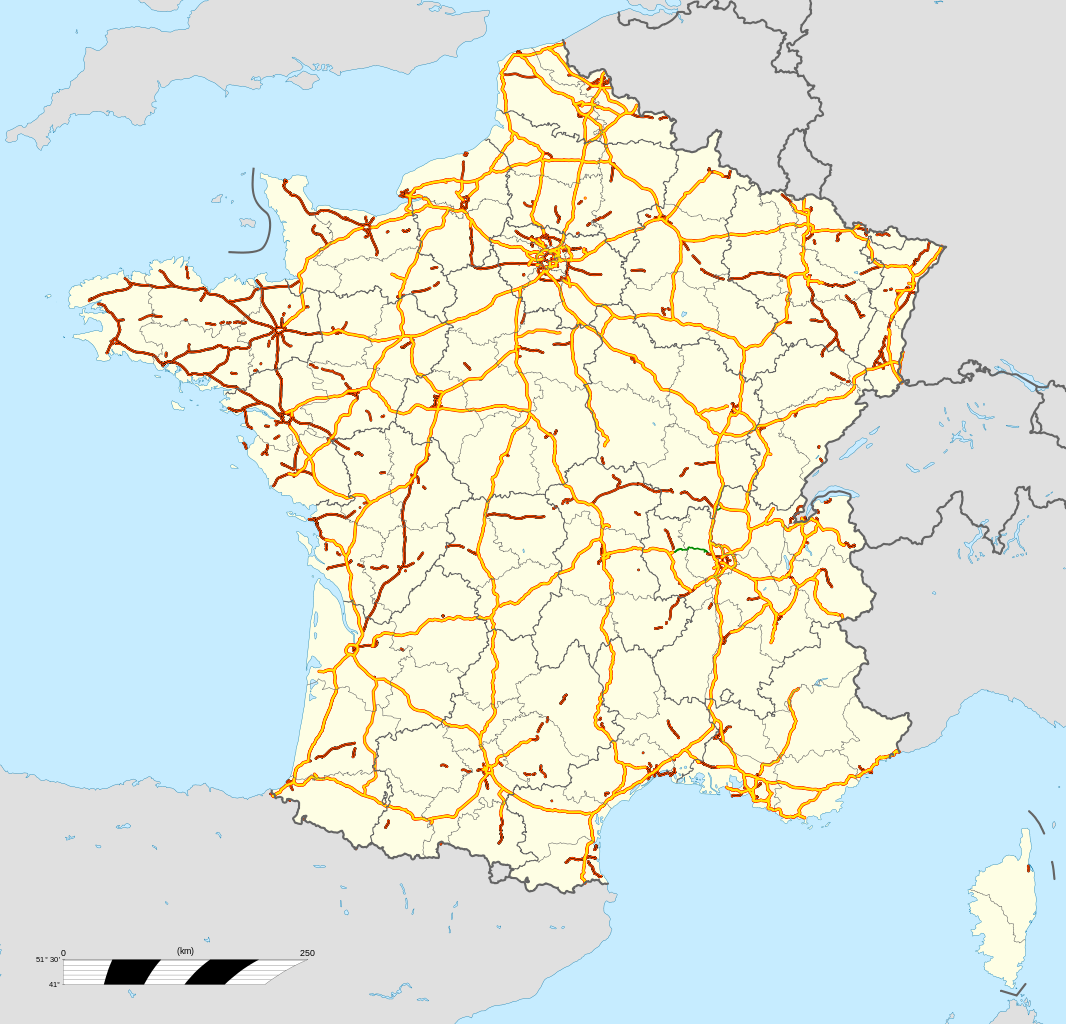
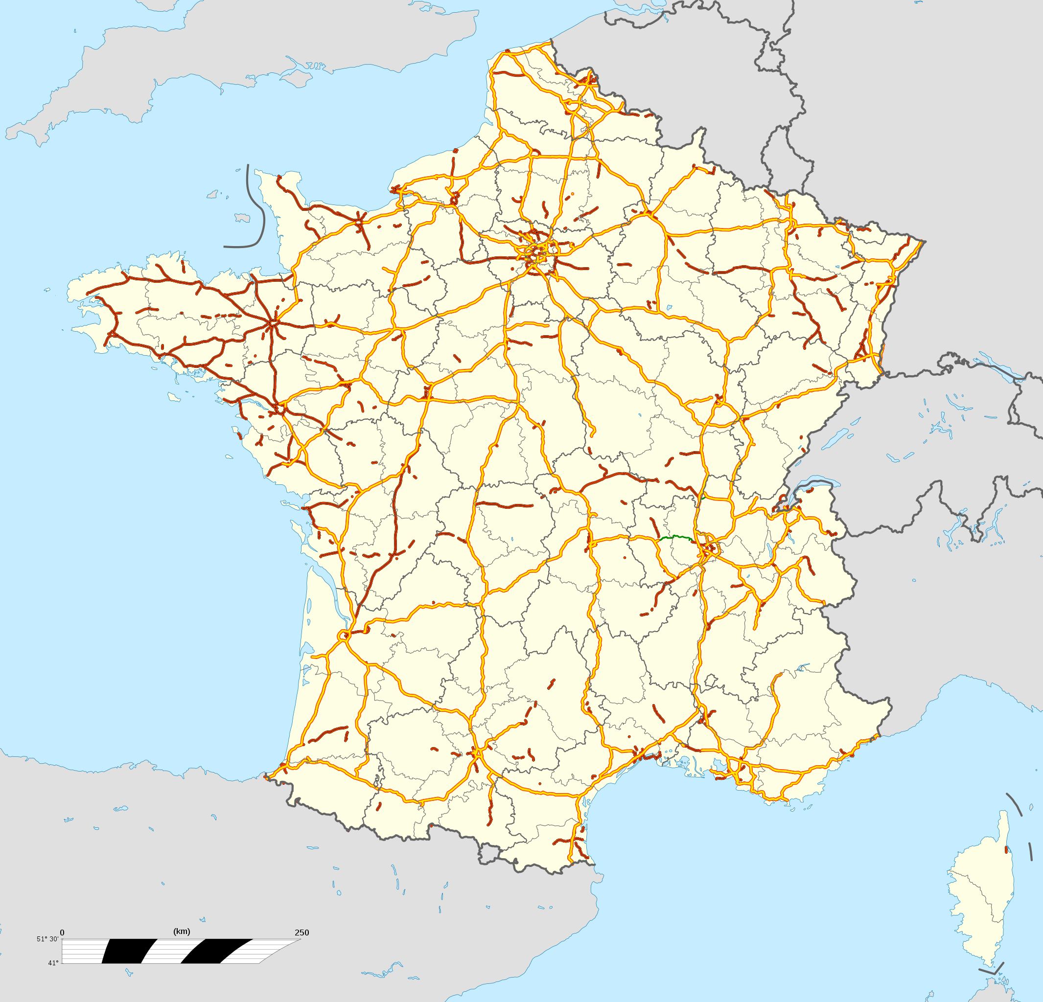
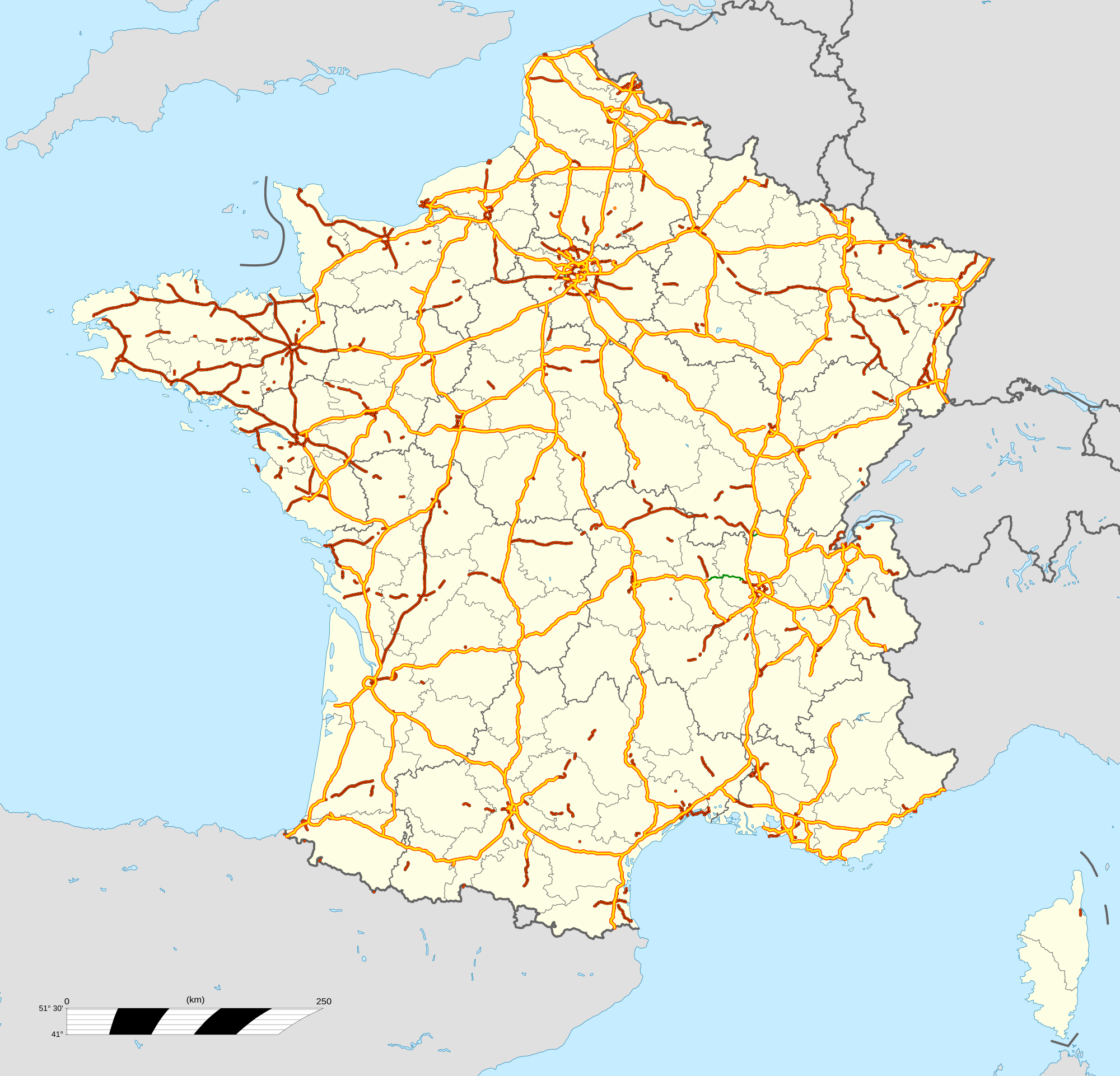
English: Map of motorways of
France, with regions and departements distinguished.
Approximate scale : 1:3,000,000 Français : Carte du
réseau autoroutier de la
France, avec régions et départements distingués.
Échelle approximative : 1:3 000 000 Equirectangular projection, WGS84 datum
Geographic limits of the map :
|
| Date | |
| Source |
Own work
|
| Author | Bourrichon (motorways) ; fond de carte / bottom map : File:France location map-Regions and departements.svg by Sting - fr:Sting |
.svg)
| Object location |
| View this and other nearby images on: OpenStreetMap |
|
|---|
Licensing
I, the copyright holder of this work, hereby publish it under the following licenses:

|
Permission is granted to copy, distribute and/or modify this document under the terms of the GNU Free Documentation License, Version 1.2 or any later version published by the Free Software Foundation; with no Invariant Sections, no Front-Cover Texts, and no Back-Cover Texts. A copy of the license is included in the section entitled GNU Free Documentation License. |
This file is licensed under the
Creative Commons Attribution-Share Alike
4.0 International,
3.0 Unported,
2.5 Generic,
2.0 Generic and
1.0 Generic license.
- You are free:
- to share – to copy, distribute and transmit the work
- to remix – to adapt the work
- Under the following conditions:
- attribution – You must give appropriate credit, provide a link to the license, and indicate if changes were made. You may do so in any reasonable manner, but not in any way that suggests the licensor endorses you or your use.
- share alike – If you remix, transform, or build upon the material, you must distribute your contributions under the same or compatible license as the original.
You may select the license of your choice.
Licensing
I, the copyright holder of this work, hereby publish it under the following license:
This file is licensed under the
Creative Commons
Attribution 3.0 Unported license.
- You are free:
- to share – to copy, distribute and transmit the work
- to remix – to adapt the work
- Under the following conditions:
- attribution – You must give appropriate credit, provide a link to the license, and indicate if changes were made. You may do so in any reasonable manner, but not in any way that suggests the licensor endorses you or your use.
File history
Click on a date/time to view the file as it appeared at that time.
| Date/Time | Thumbnail | Dimensions | User | Comment | |
|---|---|---|---|---|---|
| current | 11:17, 31 July 2012 |
| 2,000 × 1,922 (4.6 MB) | Bourrichon | actualisation : A21, A432 nord, A75→A9 |
| 11:15, 31 July 2012 |
 | 2,000 × 1,922 (4.6 MB) | Bourrichon | actualisation : A21, A432 nord, A75→A9 | |
| 00:39, 12 May 2012 |
 | 2,000 × 1,922 (3.47 MB) | Bourrichon | ||
| 23:52, 11 May 2012 |
 | 2,000 × 1,922 (2.39 MB) | Bourrichon | ||
| 18:06, 10 May 2012 |
 | 2,000 × 1,922 (3.64 MB) | Bourrichon | == {{int:filedesc}} == {{Information |Description={{en|Map of motorways of France, with regions and departements distinguished.<br/>Approximate scale : 1:3,000,000}} {{fr|Carte du réseau autoroutier... |
File usage
The following pages on the English Wikipedia use this file (pages on other projects are not listed):
Global file usage
The following other wikis use this file:
- Usage on cs.wikipedia.org
- Usage on de.wikipedia.org
- Usage on el.wikipedia.org
- Usage on es.wikipedia.org
- Usage on es.wikivoyage.org
- Usage on fr.wikipedia.org
- Usage on fr.wikivoyage.org
- Usage on fy.wikipedia.org
- Usage on he.wikivoyage.org
- Usage on it.wikipedia.org
- Usage on no.wikipedia.org
- Usage on pl.wikipedia.org
- Usage on pt.wikipedia.org
- Usage on ru.wikipedia.org
- Usage on uk.wikipedia.org
- Автомагістралі Франції
- Автомагістраль А1 (Франція)
- Автомагістраль А2 (Франція)
- Автомагістраль А3 (Франція)
- Автомагістраль А4 (Франція)
- Автомагістраль А5 (Франція)
- Автомагістраль А6 (Франція)
- Автомагістраль А7 (Франція)
- Автомагістраль А8 (Франція)
- Автомагістраль А9 (Франція)
- Автомагістраль А10 (Франція)
- Автомагістраль А11 (Франція)
- Автомагістраль А12 (Франція)
- Автомагістраль А13 (Франція)
- Автомагістраль А14 (Франція)
- Автомагістраль А15 (Франція)
- Автомагістраль А86 (Франція)
- Автомагістраль А16 (Франція)
- Автомагістраль А19 (Франція)
- Автомагістраль А20 (Франція)
- Автомагістраль А21 (Франція)
- Автомагістраль А22 (Франція)
- Автомагістраль А23 (Франція)
- Автомагістраль А25 (Франція)
- Автомагістраль А26 (Франція)
- Автомагістраль А27 (Франція)
- Автомагістраль А28 (Франція)
View more global usage of this file.