
Size of this preview:
608 × 600 pixels. Other resolutions:
243 × 240 pixels |
487 × 480 pixels.
Original file (800 × 789 pixels, file size: 309 KB, MIME type: image/jpeg)
| This is a file from the
Wikimedia Commons. Information from its
description page there is shown below. Commons is a freely licensed media file repository. You can help. |
Summary
| Photographer |
|
||||||||||||||||||||||||||
| Original caption |
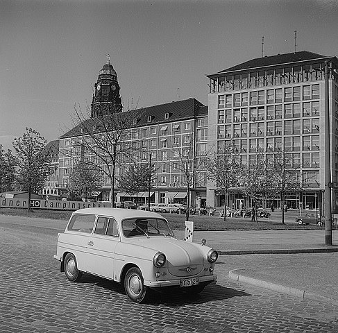
Original image description from the Deutsche Fotothek Dresden. Blick zur 5. Campingschau auf dem Grünstreifen der
Leningrader Straße am Pirnaischen Platz |
||||||||||||||||||||||||||
| Depicted place | Dresden | ||||||||||||||||||||||||||
| Date | 1961 | ||||||||||||||||||||||||||
| Collection |
|
||||||||||||||||||||||||||
| Accession number | |||||||||||||||||||||||||||
| Source | Deutsche Fotothek | ||||||||||||||||||||||||||
.jpg)
| Detailed information from the Deutsche Fotothek | |
|---|---|
| Leading tag for repeatable field group „Foto“ | Negativ |
| Owner of the photograph | Deutsche Fotothek |
| Image file name | df_ps_0002918 |
| Color | schwarzweiß |
| Photograph | Peter, Richard sen. |
| Date the picture was taken | 1961 |
| Record ID | 88953083 |
| Subject/subject heading | Stadt & Stadtlandschaften & Camping |
| Reproduced location / repeatable field group | Dresden |
| Street | Pirnaischer Platz |
| Sachbegriff/category | Foto |
| Subject/subject heading | Stadt & Stadtlandschaften & Camping |
Licensing
|
|
This file was provided to Wikimedia Commons by the
Deutsche Fotothek of the Saxon State Library / State and University Library Dresden (SLUB) as part of a
cooperation project. The Deutsche Fotothek guarantees an authentic representation only by using copies of the original images as provided by the
Digital Image Archive.
|
This file is licensed under the
Creative Commons
Attribution-Share Alike 3.0 Germany license.
Attribution: Deutsche Fotothek
- You are free:
- to share – to copy, distribute and transmit the work
- to remix – to adapt the work
- Under the following conditions:
- attribution – You must give appropriate credit, provide a link to the license, and indicate if changes were made. You may do so in any reasonable manner, but not in any way that suggests the licensor endorses you or your use.
- share alike – If you remix, transform, or build upon the material, you must distribute your contributions under the same or compatible license as the original.

| Camera location |
| View this and other nearby images on: OpenStreetMap |
|
|---|
| Object location |
| View this and other nearby images on: OpenStreetMap |
|
|---|
File history
Click on a date/time to view the file as it appeared at that time.
| Date/Time | Thumbnail | Dimensions | User | Comment | |
|---|---|---|---|---|---|
| current | 07:00, 9 March 2020 |
| 800 × 789 (309 KB) | Sebastian Wallroth | Cropped 2 % vertically using CropTool with lossless mode. Removed border. |
| 14:07, 1 October 2009 |
 | 800 × 809 (304 KB) | FotothekBot | {{Fotothek-Description | description = <!-- To override the description field --> | comment = <!-- To add a comment --> | date = <!-- To override the date field --> | author = <!-- To override the author field --> | 8450_1 = Negativ | 8450_1_8460 = Deutsc |
File usage
The following pages on the English Wikipedia use this file (pages on other projects are not listed):
Global file usage
The following other wikis use this file:
- Usage on no.wikipedia.org