
Size of this preview:
391 × 599 pixels. Other resolutions:
156 × 240 pixels |
313 × 480 pixels |
1,000 × 1,533 pixels.
Original file (1,000 × 1,533 pixels, file size: 300 KB, MIME type: image/jpeg)
| This is a file from the
Wikimedia Commons. Information from its
description page there is shown below. Commons is a freely licensed media file repository. You can help. |
Summary
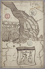
| Description | Plan of Fort Richelieu, near Sorel-Tracy, Quebec, Canada | |||
| Date | ||||
| Source |
Library and Archives Canada
|
|||
| Author | ||||
| Other versions |
|

_1.161_VILLE_DE_SOREL,_1666.jpg)
Licensing
|
This work is in the public domain in its country of origin and other countries and areas where the copyright term is the author's life plus 100 years or fewer. | |
| This file has been identified as being free of known restrictions under copyright law, including all related and neighboring rights. | |
File history
Click on a date/time to view the file as it appeared at that time.
| Date/Time | Thumbnail | Dimensions | User | Comment | |
|---|---|---|---|---|---|
| current | 14:03, 2 February 2007 |
| 1,000 × 1,533 (300 KB) | P199 | {{Information |Description=Plan of Fort Richelieu, near Sorel-Tracy, Quebec, Canada |Source=Library and Archives Canada |Date=1695 |Author= |Permission= |other_versions= }} Category:Sorel |
File usage
The following pages on the English Wikipedia use this file (pages on other projects are not listed):
Global file usage
The following other wikis use this file:
- Usage on de.wikipedia.org
- Usage on es.wikipedia.org
- Usage on fr.wikipedia.org
- Usage on it.wikipedia.org
- Usage on la.wikipedia.org