Size of this preview:
800 × 397 pixels. Other resolutions:
320 × 159 pixels |
640 × 317 pixels |
1,397 × 693 pixels.
Original file (1,397 × 693 pixels, file size: 778 KB, MIME type: image/jpeg)
| This is a file from the
Wikimedia Commons. Information from its
description page there is shown below. Commons is a freely licensed media file repository. You can help. |
_1986_01.jpg)
|
This is an image of a place or building that is listed on the
National Register of Historic Places in the
United States of America. Its reference number is
86002061. |
Summary
| Description |
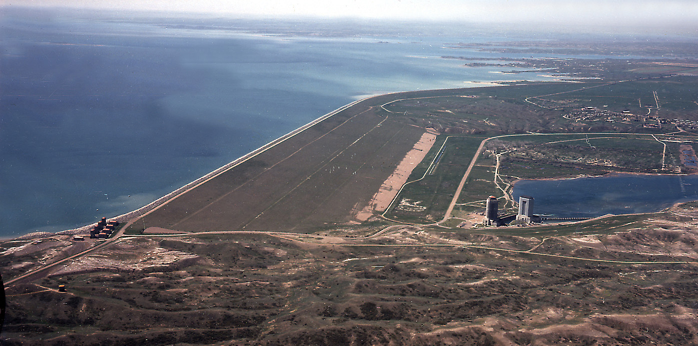
English: Aerial view of Fort Peck Dam, showing both powerhouses and dam. Missouri River, Fort Peck, Montana. |
|||
| Location | Fort Peck, Montana, USA 48°0′9.21″N 106°25′32.13″W / 48.0025583°N 106.4255917°W |
|||
| Date | ||||
| Source | U.S. Army Corps of Engineers, Digital Visual Library | |||
| Author | US Army Corps of Engineers, Photographed by Robert Etzel | |||
| Permission ( Reusing this file) |
|
_1986_01.jpg¶ms=48_0_9.21_N_106_25_32.13_W_type:city)
| Object location |
| View this and other nearby images on: OpenStreetMap |
|
|---|
_1986_01.jpg¶ms=048.004722_N_-106.419444_E_globe:Earth_class:object_region:US_type:landmark_scale:1500_&language=en)
File history
Click on a date/time to view the file as it appeared at that time.
| Date/Time | Thumbnail | Dimensions | User | Comment | |
|---|---|---|---|---|---|
| current | 16:52, 9 February 2007 |
| 1,397 × 693 (778 KB) | Ltvine | == Summary == {{Information |Description= Aerial view of Fort Peck Dam, showing both powerhouses and dam. Missouri River, Fort Peck, Montana. |Source=[http://images.usace.army.mil/ U.S. Army Corps of Engineers, Digital Visual Library] |Date=1986 |Author= |
File usage
The following pages on the English Wikipedia use this file (pages on other projects are not listed):
Global file usage
The following other wikis use this file:
- Usage on ast.wikipedia.org
- Usage on cs.wikipedia.org
- Usage on de.wikipedia.org
- Usage on es.wikipedia.org
- Usage on fr.wikipedia.org
- Usage on fr.wikivoyage.org
- Usage on gl.wikipedia.org
- Usage on hr.wikipedia.org
- Usage on it.wikipedia.org
- Usage on ja.wikipedia.org
- Usage on lt.wikipedia.org
- Usage on ml.wikipedia.org
- Usage on no.wikipedia.org
- Usage on pt.wikipedia.org
- Usage on ru.wikipedia.org
- Usage on ta.wikipedia.org
- Usage on uk.wikipedia.org
- Usage on www.wikidata.org
_1986_01.jpg)