
Size of this preview:
800 × 600 pixels. Other resolutions:
320 × 240 pixels |
640 × 480 pixels |
1,024 × 768 pixels |
1,280 × 960 pixels |
2,592 × 1,944 pixels.
Original file (2,592 × 1,944 pixels, file size: 3.59 MB, MIME type: image/jpeg)
| This is a file from the
Wikimedia Commons. Information from its
description page there is shown below. Commons is a freely licensed media file repository. You can help. |
Summary
|
This is an image of a place or building that is listed on the
National Register of Historic Places in the
United States of America. Its reference number is
70000921. |
| Description |
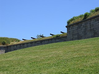
<a href=" http://www.nine3.com/MDC/history.html" target="_blank">Fort Independence</a>, Castle Island, South Boston. Quickly appreciated for its strategic location for the protection of Boston from sea attack, the first fortification on Castle Island was an earthwork and three cannon ordered in 1634 by Governor Dudley of Massachusetts Bay Colony. After the evacuating British destroyed the island's fortifications 1776, the fort was repaired by troops under the command of Lt. Paul Revere. |
| Date | |
| Source | Fort Independence, Castle Island, South Boston |
| Author | Paul Keleher from Mass, US |
| Object location |
| View this and other nearby images on: OpenStreetMap |
|
|---|
Licensing
This file is licensed under the
Creative Commons
Attribution 2.0 Generic license.
- You are free:
- to share – to copy, distribute and transmit the work
- to remix – to adapt the work
- Under the following conditions:
- attribution – You must give appropriate credit, provide a link to the license, and indicate if changes were made. You may do so in any reasonable manner, but not in any way that suggests the licensor endorses you or your use.
| This image was originally posted to Flickr by Paul Keleher at https://www.flickr.com/photos/57253263@N00/30278057. It was reviewed on 12 October 2007 by FlickreviewR and was confirmed to be licensed under the terms of the cc-by-2.0. |
File history
Click on a date/time to view the file as it appeared at that time.
| Date/Time | Thumbnail | Dimensions | User | Comment | |
|---|---|---|---|---|---|
| current | 19:32, 11 October 2007 |
| 2,592 × 1,944 (3.59 MB) | File Upload Bot (Magnus Manske) | {{Information |Description= <a href="http://www.nine3.com/MDC/history.html" target="_blank">Fort Independence</a>, Castle Island, South Boston. Quickly appreciated for its strategic location for the protection of Boston from sea attack, the first forti |
File usage
The following pages on the English Wikipedia use this file (pages on other projects are not listed):
Global file usage
The following other wikis use this file:
- Usage on bn.wikipedia.org
- Usage on de.wikipedia.org
- Usage on pl.wikipedia.org