
Size of this preview:
800 × 181 pixels. Other resolutions:
320 × 72 pixels |
640 × 145 pixels |
1,024 × 231 pixels |
1,280 × 289 pixels |
2,560 × 578 pixels |
9,952 × 2,247 pixels.
Original file (9,952 × 2,247 pixels, file size: 17.34 MB, MIME type: image/jpeg)
| This is a file from the
Wikimedia Commons. Information from its
description page there is shown below. Commons is a freely licensed media file repository. You can help. |
|
| This is a featured picture, which means that members of the community have identified it as one of the finest images on the English Wikipedia, adding significantly to its accompanying article. If you have a different image of similar quality, be sure to upload it using the proper free license tag, add it to a relevant article, and nominate it. |
|
| This image was selected as picture of the day on the English Wikipedia for February 26, 2011. |
Summary
| Description |
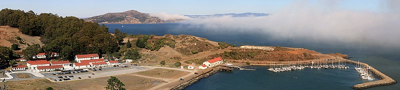
English: The Fort Baker, which borders the City of
w:Sausalito in
w:Marin County and is connected to
w:San Francisco by the
w:Golden Gate Bridge, served as an
Army post until the mid-1990s, when the headquarters of the
91st Division moved to
w:Parks Reserve Forces Training Area.The famous
w:San Francisco fog is seen at the Bay
Français : Fort Baker, juste au bord de la ville de
Sausalito en Californie, de l'autre doté du Golden gate. Ce fort a été utilisé par l'armée américaine jusqu'au milieu des années 90, quand l'état major de la 91e division d'infanterie a quitté les lieux. Au loin, le célèbre brouillard de San Francisco couvre la baie. |
| Date | |
| Source | Own work |
| Author | Brocken Inaglory |
|

| Camera location |
| View this and other nearby images on: OpenStreetMap |
|
|---|
Licensing
I, the copyright holder of this work, hereby publish it under the following licenses:
This file is licensed under the
Creative Commons
Attribution-Share Alike 3.0 Unported license.
- You are free:
- to share – to copy, distribute and transmit the work
- to remix – to adapt the work
- Under the following conditions:
- attribution – You must give appropriate credit, provide a link to the license, and indicate if changes were made. You may do so in any reasonable manner, but not in any way that suggests the licensor endorses you or your use.
- share alike – If you remix, transform, or build upon the material, you must distribute your contributions under the same or compatible license as the original.

|
Permission is granted to copy, distribute and/or modify this document under the terms of the GNU Free Documentation License, Version 1.2 or any later version published by the Free Software Foundation; with no Invariant Sections, no Front-Cover Texts, and no Back-Cover Texts. A copy of the license is included in the section entitled GNU Free Documentation License. |
You may select the license of your choice.
File history
Click on a date/time to view the file as it appeared at that time.
| Date/Time | Thumbnail | Dimensions | User | Comment | |
|---|---|---|---|---|---|
| current | 00:41, 24 September 2009 |
| 9,952 × 2,247 (17.34 MB) | Mbz1 | fixed errors |
| 19:47, 16 September 2009 |
| 9,952 × 2,247 (17.31 MB) | Mbz1 | fixed errors | |
| 19:19, 16 September 2009 |
| 9,952 × 2,247 (17.27 MB) | Mbz1 | fixed errors | |
| 19:08, 16 September 2009 |
| 9,953 × 2,261 (17.41 MB) | Mbz1 | Fixed | |
| 16:17, 16 September 2009 |
| 9,953 × 2,261 (17.34 MB) | Mbz1 | {{Information |Description={{en|1=Fort Baker and Angel Island}} |Source=Own work by uploader |Author= Mbz1 |Date=2009-15-09 |Permission= |other_versions= }} Category:San Francisco Bay |
File usage
The following pages on the English Wikipedia use this file (pages on other projects are not listed):
- Fort Baker
- Talk:Fort Baker
- User:Mercurywoodrose/SFBA galleries
- User talk:Mbz1/Archive1
- User talk:Mbz1/Archive 1
- User talk:Mbz1/a7
- User talk:Mbz1/a77
- Wikipedia:Featured picture candidates/File:Fort Baker and Angel Island.jpg
- Wikipedia:Featured picture candidates/September-2009
- Wikipedia:Featured pictures/Places/Panorama
- Wikipedia:Featured pictures thumbs/20
- Wikipedia:Main Page history/2011 February 26
- Wikipedia:Picture of the day/February 2011
- Wikipedia:WikiProject Military history/Showcase
- Wikipedia:WikiProject Military history/Showcase/FP
- Wikipedia:WikiProject United States/Featured pictures
- Wikipedia:WikiProject United States/Quality content
- Wikipedia:WikiProject United States/Recognized content
- Wikipedia:Wikipedia Signpost/2009-09-28/Features and admins
- Wikipedia:Wikipedia Signpost/2009-09-28/SPV
- Template:POTD/2011-02-26
- Portal:San Francisco Bay Area/Selected panorama/2
- Portal:San Francisco Bay Area/Selected panorama/Archive
- Portal:United States/Selected panorama
- Portal:United States/Selected panorama/23
Global file usage
The following other wikis use this file:
- Usage on bn.wikipedia.org
- Usage on cs.wikipedia.org
- Usage on de.wikipedia.org
- Usage on kn.wikipedia.org
- Usage on mg.wikipedia.org
- Usage on pl.wikipedia.org
- Usage on pt.wikipedia.org
- Usage on ur.wikipedia.org
- Usage on vi.wikipedia.org