
Size of this preview:
800 × 600 pixels. Other resolutions:
320 × 240 pixels |
640 × 480 pixels |
1,024 × 768 pixels |
1,280 × 960 pixels |
1,600 × 1,200 pixels.
Original file (1,600 × 1,200 pixels, file size: 496 KB, MIME type: image/jpeg)
| This is a file from the
Wikimedia Commons. Information from its
description page there is shown below. Commons is a freely licensed media file repository. You can help. |
|
This is an image of a place or building that is listed on the
National Register of Historic Places in the
United States of America. Its reference number is
85002433. |
Summary
| Description |
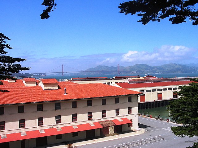
English: Historic warehouses and piers near Fort Mason, used during WW2 for embarking men and supplies to the distant battlefronts in the Southwest Pacific.
Photographed by
en:User:SuperJumbo April 2005. |
| Date | 11 September 2005 (original upload date) |
| Source | Transferred from en.wikipedia |
| Author | Original uploader was SuperJumbo at en.wikipedia |
| Permission ( Reusing this file) |
GFDL-WITH-DISCLAIMERS; Released under the GNU Free Documentation License. |
| Object location |
| View this and other nearby images on: OpenStreetMap |
|
|---|
Licensing

|
Permission is granted to copy, distribute and/or modify this document under the terms of the GNU Free Documentation License, Version 1.2 or any later version published by the Free Software Foundation; with no Invariant Sections, no Front-Cover Texts, and no Back-Cover Texts. A copy of the license is included in the section entitled GNU Free Documentation License. Subject to disclaimers. |
Original upload log
The original description page was
here. All following user names refer to en.wikipedia.
- 2005-09-11 10:27 SuperJumbo 1600×1200×??? (507612 bytes) Historic warehouses and piers near Fort Mason, used during WW2 for embarking men and supplies to the distant battlefronts in the Southwest Pacific. Photographed by [[User:SuperJumbo]] April 2005. {{GFDL}}
Licensing
| This file is licensed under the Creative Commons Attribution-Share Alike 3.0 Unported license. Subject to disclaimers. | ||
| ||
| This licensing tag was added to this file as part of the GFDL licensing update. |
|
|
Permission is granted to copy, distribute and/or modify this document under the terms of the GNU Free Documentation License, Version 1.2 or any later version published by the Free Software Foundation; with no Invariant Sections, no Front-Cover Texts, and no Back-Cover Texts. A copy of the license is included in the section entitled GNU Free Documentation License. Subject to disclaimers. |
File history
Click on a date/time to view the file as it appeared at that time.
| Date/Time | Thumbnail | Dimensions | User | Comment | |
|---|---|---|---|---|---|
| current | 00:11, 13 August 2008 |
| 1,600 × 1,200 (496 KB) | Captndelta | {{Information |Description={{en|Historic warehouses and piers near Fort Mason, used during WW2 for embarking men and supplies to the distant battlefronts in the Southwest Pacific. Photographed by en:User:SuperJumbo April 2005.}} |Source=Transferred |
File usage
The following pages on the English Wikipedia use this file (pages on other projects are not listed):
Global file usage
The following other wikis use this file:
- Usage on de.wikipedia.org
- Usage on fr.wikipedia.org
- Usage on id.wikipedia.org
- Usage on mk.wikipedia.org
- Usage on no.wikipedia.org
- Usage on pt.wikipedia.org