No higher resolution available.
Floridamap2.png (491 × 464 pixels, file size: 18 KB, MIME type: image/png)
| This is a file from the
Wikimedia Commons. Information from its
description page there is shown below. Commons is a freely licensed media file repository. You can help. |
Summary
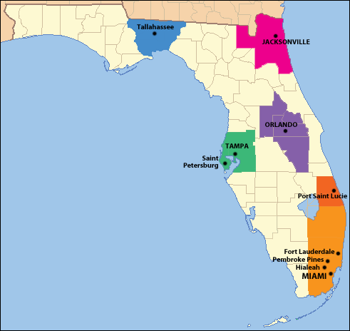
| Description |
English: New map as per 2010 US Census showing cities with a population greater than 150,000, and their respective metro areas. |
| Date | (UTC) |
| Source | Own work (Original text: I ( Comayagua99 ( talk)) created this work entirely by myself.) |
| Author | Comayagua99 ( talk) |
Licensing
Comayagua99 at
English Wikipedia, the copyright holder of this work, hereby publishes it under the following licenses:
This file is licensed under the
Creative Commons
Attribution-Share Alike 3.0 Unported license.
Attribution:
Comayagua99 at
English Wikipedia
- You are free:
- to share – to copy, distribute and transmit the work
- to remix – to adapt the work
- Under the following conditions:
- attribution – You must give appropriate credit, provide a link to the license, and indicate if changes were made. You may do so in any reasonable manner, but not in any way that suggests the licensor endorses you or your use.
- share alike – If you remix, transform, or build upon the material, you must distribute your contributions under the same or compatible license as the original.

|
Permission is granted to copy, distribute and/or modify this document under the terms of the GNU Free Documentation License, Version 1.2 or any later version published by the Free Software Foundation; with no Invariant Sections, no Front-Cover Texts, and no Back-Cover Texts. A copy of the license is included in the section entitled GNU Free Documentation License. |
You may select the license of your choice.
Original upload log
The original description page was
here. All following user names refer to en.wikipedia.
- 2012-02-26 19:18 Comayagua99 491×464× (18241 bytes)
- 2012-02-26 18:39 Comayagua99 491×464× (18804 bytes) New map as per 2010 US Census showing cities with a population greater than 150,000, and their respective metro areas.
- 2012-02-20 13:56 Mgreason 491×464× (20720 bytes) added color to identify metropolitan statistical areas
- 2011-01-16 18:15 Comayagua99 491×464× (23427 bytes) {{Information |Description = |Source = I (~~~) created this work entirely by myself. |Date = ~~~~~ |Author = ~~~ |other_versions = }}
File history
Click on a date/time to view the file as it appeared at that time.
| Date/Time | Thumbnail | Dimensions | User | Comment | |
|---|---|---|---|---|---|
| current | 15:55, 11 May 2014 |
| 491 × 464 (18 KB) | OgreBot | (BOT): Reverting to most recent version before archival |
| 15:54, 11 May 2014 |
 | 491 × 464 (18 KB) | OgreBot | (BOT): Uploading old version of file from en.wikipedia; originally uploaded on 2012-02-26 18:39:40 by Comayagua99 | |
| 15:54, 11 May 2014 |
 | 491 × 464 (20 KB) | OgreBot | (BOT): Uploading old version of file from en.wikipedia; originally uploaded on 2012-02-20 13:56:56 by Mgreason | |
| 15:54, 11 May 2014 |
 | 491 × 464 (23 KB) | OgreBot | (BOT): Uploading old version of file from en.wikipedia; originally uploaded on 2011-01-16 18:15:57 by Comayagua99 | |
| 16:35, 7 May 2014 |
 | 491 × 464 (18 KB) | Frenzie23 | Transferred from en.wikipedia |
File usage
The following pages on the English Wikipedia use this file (pages on other projects are not listed):
Global file usage
The following other wikis use this file:
- Usage on ca.wikipedia.org