
Original file (1,808 × 1,808 pixels, file size: 2.35 MB, MIME type: image/jpeg)
| This is a file from the
Wikimedia Commons. Information from its
description page there is shown below. Commons is a freely licensed media file repository. You can help. |
.jpg)
Summary
| Description |
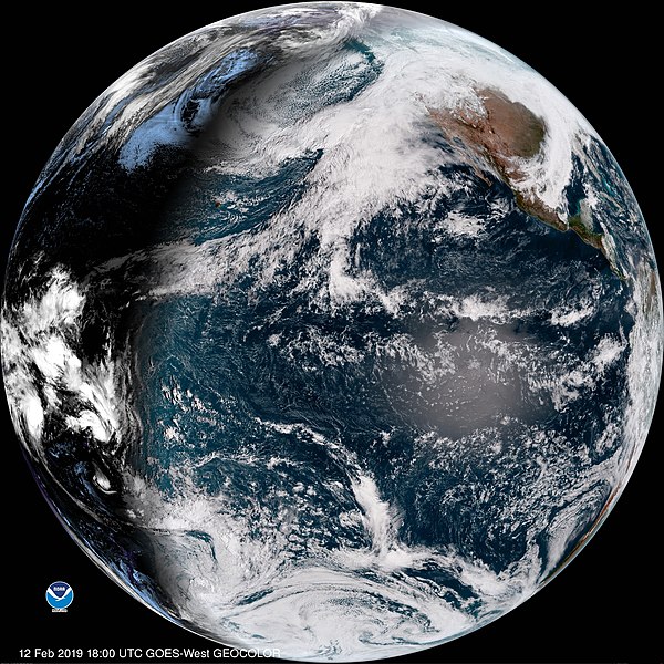
GOES-17 is now operational as NOAA’s GOES West. In its new role, GOES-17 is providing faster, more accurate, and more detailed observations for detecting and monitoring Pacific storm systems, fog, wildfires, and other weather phenomena that affect the western United States, Alaska, and Hawaii. Located at 137.2 degrees west longitude, GOES-17 replaces GOES-15 as NOAA’s operational GOES West. GOES-17 joins GOES-16, in operations as NOAA’s GOES East, in delivering high-resolution visible and infrared imagery and lightning observations of more than half the globe – from the west coast of Africa to New Zealand and from near the Arctic Circle to the Antarctic Circle. GOES-17 operational announcement: <a href=" https://go.usa.gov/xEnhw" rel="noreferrer nofollow">go.usa.gov/xEnhw</a> Learn more about the benefits GOES-17 is bringing to forecasting in the western U.S. at <a href=" https://go.usa.gov/xEnzB" rel="noreferrer nofollow">go.usa.gov/xEnzB</a> Check out the new GOES West Image Viewer: <a href=" https://go.usa.gov/xEQqX" rel="noreferrer nofollow">go.usa.gov/xEQqX</a> |
| Date | |
| Source | First Full Disk Image from GOES-17 as GOES West |
| Author | NOAA Satellites |
Licensing
This image is in the
public domain because it contains materials that originally came from the U.S.
National Oceanic and Atmospheric Administration, taken or made as part of an employee's official duties.
|
| This image, originally posted to Flickr, was reviewed on 24 September 2019 by the administrator or reviewer Chenzw, who confirmed that it was available on Flickr under the stated license on that date. |
File history
Click on a date/time to view the file as it appeared at that time.
| Date/Time | Thumbnail | Dimensions | User | Comment | |
|---|---|---|---|---|---|
| current | 15:24, 14 February 2019 |
| 1,808 × 1,808 (2.35 MB) | MarginalCost | Transferred from Flickr via #flickr2commons |
File usage
Global file usage
The following other wikis use this file:
- Usage on tr.wikipedia.org
.jpg)