
Size of this preview:
776 × 600 pixels. Other resolutions:
311 × 240 pixels |
621 × 480 pixels |
994 × 768 pixels |
1,056 × 816 pixels.
Original file (1,056 × 816 pixels, file size: 808 KB, MIME type: image/jpeg)
| This is a file from the
Wikimedia Commons. Information from its
description page there is shown below. Commons is a freely licensed media file repository. You can help. |
Summary
| Description |
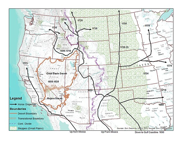
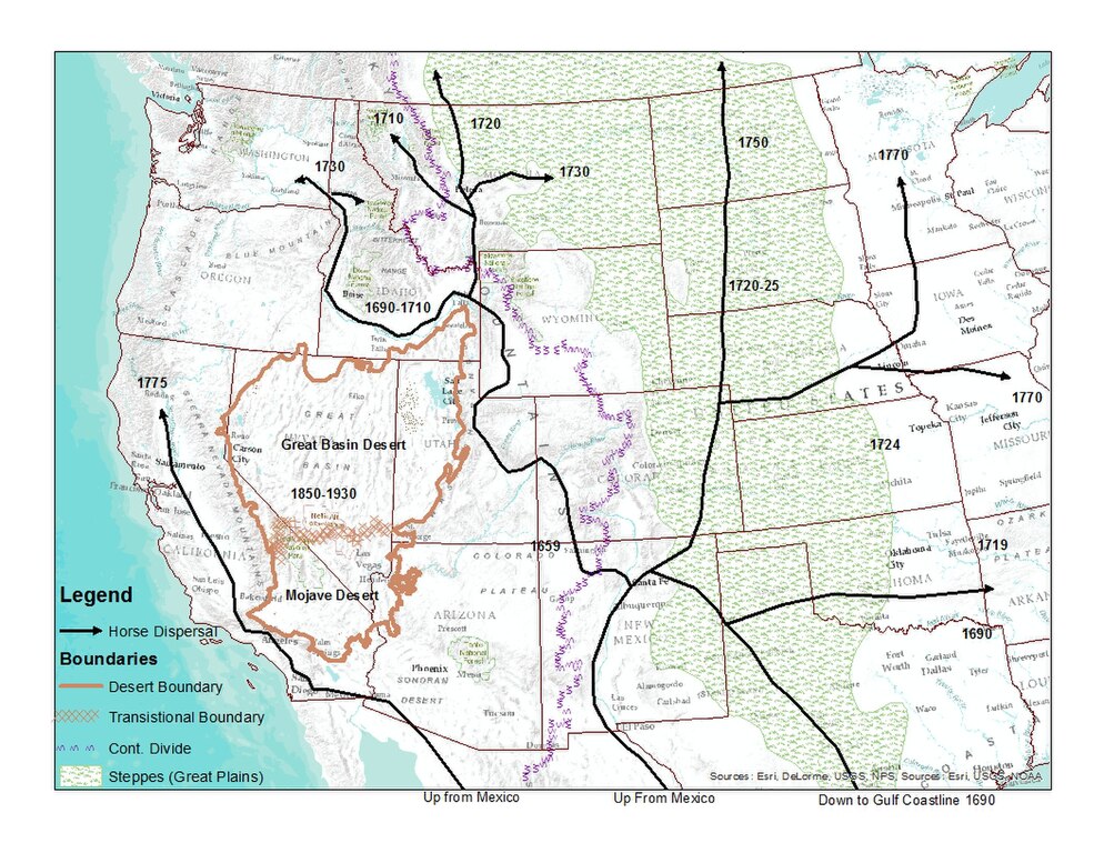
English: Map with facsimile of horse dispersal from a map at: Haines, Francis. "The Northward Spread of Horses Among the Plains Indians." American Anthropologist New Series, Vol. 40, No. 3 (Jul. - Sep., 1938), pp. 429-437 at p. 430
online version. Depictions of the Great Basin and Continental Divide from USGS hydrographic .shp files. Depiction of the Great Plains from
this map |
| Date | |
| Source | Own work |
| Author | LynnWysong |
Licensing
I, the copyright holder of this work, hereby publish it under the following license:
This file is licensed under the
Creative Commons
Attribution-Share Alike 4.0 International license.
- You are free:
- to share – to copy, distribute and transmit the work
- to remix – to adapt the work
- Under the following conditions:
- attribution – You must give appropriate credit, provide a link to the license, and indicate if changes were made. You may do so in any reasonable manner, but not in any way that suggests the licensor endorses you or your use.
- share alike – If you remix, transform, or build upon the material, you must distribute your contributions under the same or compatible license as the original.
File history
Click on a date/time to view the file as it appeared at that time.
| Date/Time | Thumbnail | Dimensions | User | Comment | |
|---|---|---|---|---|---|
| current | 15:34, 1 August 2015 |
| 1,056 × 816 (808 KB) | LynnWysong | Used EPA and WWF GIS ecoregion files to make desert boundaries rather than Great Basin hydrographic boundariy. Also used ecoregion boundarie to define the Great Plains |
| 23:38, 16 June 2015 |
 | 1,056 × 816 (765 KB) | LynnWysong | User created page with UploadWizard |
File usage
The following pages on the English Wikipedia use this file (pages on other projects are not listed):
Global file usage
The following other wikis use this file:
- Usage on ca.wikipedia.org
- Usage on eo.wikipedia.org
- Usage on gl.wikipedia.org
- Usage on ko.wikipedia.org