Size of this JPG preview of this PDF file:
390 × 599 pixels. Other resolutions:
156 × 240 pixels |
313 × 480 pixels |
806 × 1,237 pixels.
Original file (806 × 1,237 pixels, file size: 240 KB, MIME type: application/pdf)
| This is a file from the
Wikimedia Commons. Information from its
description page there is shown below. Commons is a freely licensed media file repository. You can help. |
Summary
| Description |
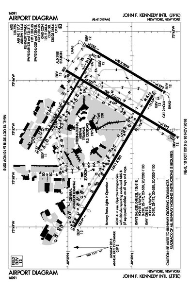
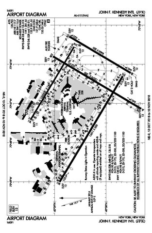
English: Aiport diagram of John F. Kennedy International aiport, as published by the FAA, containing runway and taxiway information among other aeronautical markers. |
| Date | |
| Source | https://www.faa.gov/airports/runway_safety/diagrams/ |
| Author | Federal Aviation Administration |
| Camera location |
| View this and other nearby images on: OpenStreetMap |
|
|---|
Licensing
This image or file is a work of a
Federal Aviation Administration employee, taken or made as part of that person's official duties. As a
work of the
U.S. federal government, the image is in the
public domain in the United States.
|
 |
File history
Click on a date/time to view the file as it appeared at that time.
| Date/Time | Thumbnail | Dimensions | User | Comment | |
|---|---|---|---|---|---|
| current | 05:09, 28 October 2016 |
 | 806 × 1,237 (240 KB) | Parent5446 | User created page with UploadWizard |
File usage
The following pages on the English Wikipedia use this file (pages on other projects are not listed):
Global file usage
The following other wikis use this file:
- Usage on af.wikipedia.org
- Usage on ml.wikipedia.org
- Usage on my.wikipedia.org
- Usage on simple.wikipedia.org
- Usage on ur.wikipedia.org
- Usage on www.wikidata.org