Size of this preview:
800 × 362 pixels. Other resolutions:
320 × 145 pixels |
640 × 290 pixels |
1,024 × 463 pixels |
2,000 × 905 pixels.
Original file (2,000 × 905 pixels, file size: 1.87 MB, MIME type: image/png)
| This is a file from the
Wikimedia Commons. Information from its
description page there is shown below. Commons is a freely licensed media file repository. You can help. |
Summary

|
This map image could be re-created using
vector graphics as an
SVG file. This has several advantages; see
Commons:Media for cleanup for more information. If an SVG form of this image is available, please upload it and afterwards replace this template with
{{
vector version available|new image name}}
.
It is recommended to name the SVG file “Expedition Cabeza de Vaca Karte.svg”—then the template Vector version available (or Vva) does not need the new image name parameter. |
| Description |
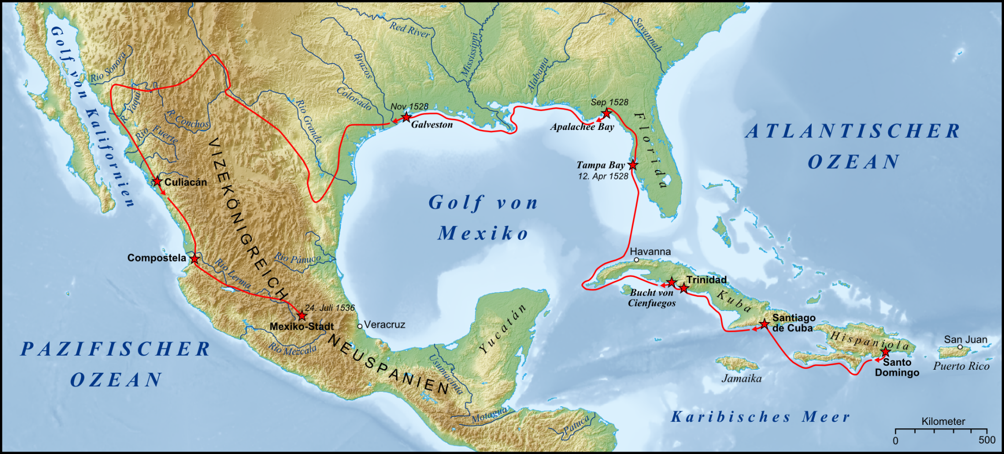
English: Expedition of Álvar Núñez Cabeza de Vaca 1528 bis 1536 Español: Expedition des
Álvar Núñez Cabeza de Vaca 1528 bis 1536 |
| Date | |
| Source |
Own work (Original text: own work, used:)
|
| Author | Lencer |
| Other versions |
.png)
Licensing
The map has been created with the
Generic Mapping Tools:
https://www.generic-mapping-tools.org/ using one or more of these
public-domain datasets for the relief:
|

|
Permission is granted to copy, distribute and/or modify this document under the terms of the GNU Free Documentation License, Version 1.2 or any later version published by the Free Software Foundation; with no Invariant Sections, no Front-Cover Texts, and no Back-Cover Texts. A copy of the license is included in the section entitled GNU Free Documentation License. |
| This file is licensed under the Creative Commons Attribution-Share Alike 3.0 Unported license. | ||
| ||
| This licensing tag was added to this file as part of the GFDL licensing update. |

|
This map has been made or improved in the German
Kartenwerkstatt (Map Lab). You can
propose maps to improve as well.
|
File history
Click on a date/time to view the file as it appeared at that time.
| Date/Time | Thumbnail | Dimensions | User | Comment | |
|---|---|---|---|---|---|
| current | 17:31, 16 January 2009 |
| 2,000 × 905 (1.87 MB) | Lencer | {{Information |Description= |Source= |Date= |Author= |Permission= |other_versions= }} |
| 16:22, 16 January 2009 |
 | 2,000 × 905 (1.85 MB) | Lencer | {{Information| |Description=Karte des Nationalparks Plitvicer Seen in Kroatien |Source=own work, used: * Generic Mapping Tools and SRTM30-files for relief |Date=Januar 2008 |
File usage
The following pages on the English Wikipedia use this file (pages on other projects are not listed):
Global file usage
The following other wikis use this file:
- Usage on ar.wikipedia.org
- Usage on avk.wikipedia.org
- Usage on bg.wikipedia.org
- Usage on ca.wikipedia.org
- Usage on cs.wikipedia.org
- Usage on de.wikipedia.org
- Usage on es.wikipedia.org
- Usage on eu.wikipedia.org
- Usage on fr.wikipedia.org
- Usage on gl.wikipedia.org
- Usage on he.wikipedia.org
- Usage on hu.wikipedia.org
- Usage on hy.wikipedia.org
- Usage on it.wikipedia.org
- Usage on ja.wikipedia.org
- Usage on lt.wikipedia.org
- Usage on nl.wikipedia.org
- Usage on no.wikipedia.org
View more global usage of this file.