No higher resolution available.
Excerpt_from_legend_of_Olano_Map.jpg (515 × 504 pixels, file size: 146 KB, MIME type: image/jpeg)
| This is a file from the
Wikimedia Commons. Information from its
description page there is shown below. Commons is a freely licensed media file repository. You can help. |
Summary
| Description |
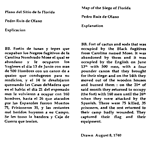
English: This excerpt is from the legend of the Plano del Sitio de la Florida, a map of St. Augustine, Florida drawn by Spanish royal engineer Pedro Ruiz de Olano in 1740. It shows the location of Fort Mose, part of the town's defensive network. The text was transcribed and translated by Charles A. Tingley of the St. Augustine Historical Society Research Library. |
| Date | |
| Source | Plano del Sitio de la Florida 1740, map drawn by Royal Engineer Pedro Ruiz de Olano |
| Author | Pedro Ruiz de Olano |
Licensing
|
This work is in the public domain in its country of origin and other countries and areas where the copyright term is the author's life plus 70 years or fewer. This work is in the public domain in the United States because it was published (or registered with the U.S. Copyright Office) before January 1, 1929. | |
| This file has been identified as being free of known restrictions under copyright law, including all related and neighboring rights. | |
File history
Click on a date/time to view the file as it appeared at that time.
| Date/Time | Thumbnail | Dimensions | User | Comment | |
|---|---|---|---|---|---|
| current | 05:53, 4 August 2019 |
| 515 × 504 (146 KB) | Carlstak | User created page with UploadWizard |
File usage
The following pages on the English Wikipedia use this file (pages on other projects are not listed):