Size of this preview:
408 × 599 pixels. Other resolutions:
163 × 240 pixels |
327 × 480 pixels |
640 × 939 pixels.
Original file (640 × 939 pixels, file size: 124 KB, MIME type: image/jpeg)
| This is a file from the
Wikimedia Commons. Information from its
description page there is shown below. Commons is a freely licensed media file repository. You can help. |
Summary
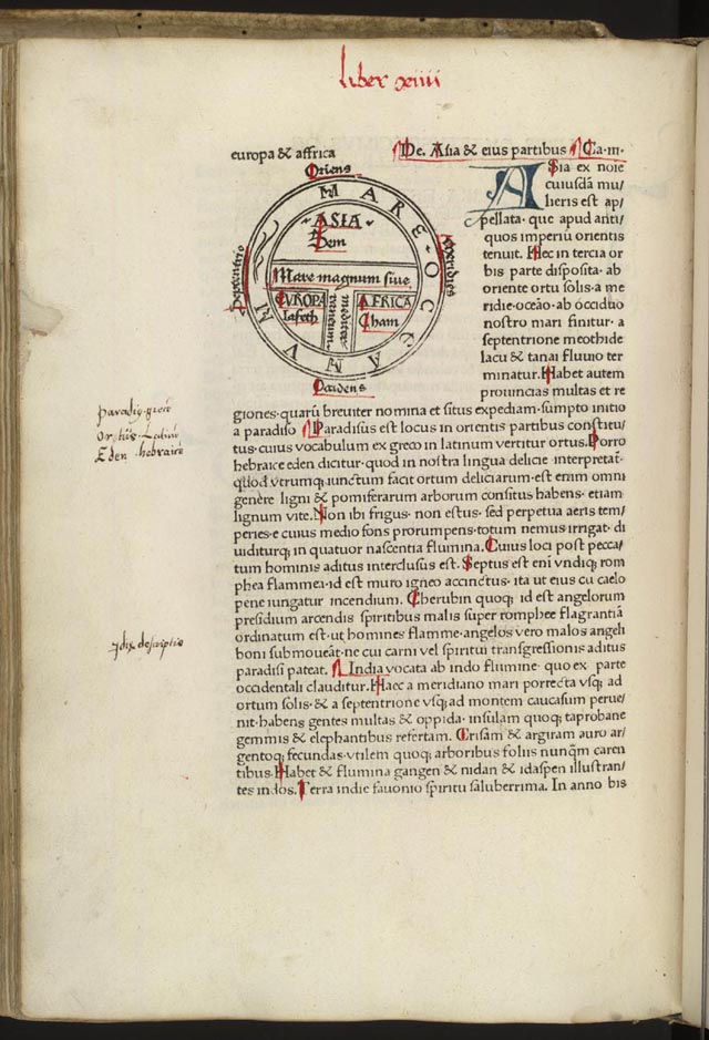
| Etymologiae, Guntherus Ziner, 1472 | |
|---|---|
| Artist |
Isidore of Seville |
| Author |
Guntherus Ziner |
| Title |
Etymologiae, Guntherus Ziner, 1472 |
| Description |
|
| Date | 1472 |
| Source/Photographer | https://www.loc.gov/exhibits/exploring-the-early-americas/interactives/heavens-and-earth/earth/artifact6-earth.html |
| Other versions |
|


.png)
Licensing
|
This is a faithful photographic reproduction of a two-dimensional,
public domain work of art. The work of art itself is in the public domain for the following reason:
The official position taken by the Wikimedia Foundation is that "faithful reproductions of two-dimensional public domain works of art are public domain".
This photographic reproduction is therefore also considered to be in the public domain in the United States. In other jurisdictions, re-use of this content may be restricted; see Reuse of PD-Art photographs for details. | ||||
File history
Click on a date/time to view the file as it appeared at that time.
| Date/Time | Thumbnail | Dimensions | User | Comment | |
|---|---|---|---|---|---|
| current | 10:24, 24 May 2005 |
| 640 × 939 (124 KB) | Dbachmann | {{PD-art}} |
File usage
The following pages on the English Wikipedia use this file (pages on other projects are not listed):
Global file usage
The following other wikis use this file:
- Usage on be-tarask.wikipedia.org
- Usage on be.wikipedia.org
- Usage on ca.wikipedia.org
- Usage on cs.wikipedia.org
- Usage on es.wikipedia.org
- Usage on fr.wikipedia.org
- Usage on gl.wikipedia.org
- Usage on gu.wikipedia.org
- Usage on ht.wikipedia.org
- Usage on hy.wikipedia.org
- Usage on it.wikipedia.org
- Usage on ja.wikipedia.org
- Usage on kk.wikipedia.org
- Usage on la.wikipedia.org
- Usage on pt.wikipedia.org
- Usage on ru.wikipedia.org
- Usage on sk.wikipedia.org
- Usage on ta.wikipedia.org
- Usage on uk.wikipedia.org