
Size of this preview:
800 × 571 pixels. Other resolutions:
320 × 229 pixels |
640 × 457 pixels |
1,024 × 731 pixels |
1,144 × 817 pixels.
Original file (1,144 × 817 pixels, file size: 32 KB, MIME type: image/png)
| This is a file from the
Wikimedia Commons. Information from its
description page there is shown below. Commons is a freely licensed media file repository. You can help. |
Summary
| Description |
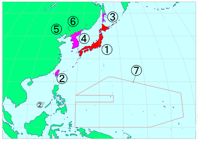
日本語: 大日本帝国の国土(昭和期)1. 内地、2. 台湾、2'. 新南群島、3. 樺太、4. 朝鮮(以上領土)、5. 関東州、6. 満鉄附属地、7. 南洋群島。
English: Location of the South Sea archipelago (7) and the Empire of Japan under Showa period (1. Mainland, 2. Taiwan, 2'. Spratly Islands, 3. Sakhalin, 4. Korea, 5. Kanto, 6. Mantetsu attached land) |
| Date | 29 July 2006 (original upload date) |
| Source | No machine-readable source provided. Own work assumed (based on copyright claims). |
| Author | No machine-readable author provided. Wakwak assumed (based on copyright claims). |
Licensing
I, the copyright holder of this work, hereby publish it under the following licenses:

|
Permission is granted to copy, distribute and/or modify this document under the terms of the GNU Free Documentation License, Version 1.2 or any later version published by the Free Software Foundation; with no Invariant Sections, no Front-Cover Texts, and no Back-Cover Texts. A copy of the license is included in the section entitled GNU Free Documentation License. |
| This file is licensed under the Creative Commons Attribution-Share Alike 3.0 Unported license. | ||
| ||
| This licensing tag was added to this file as part of the GFDL licensing update. |
This file is licensed under the
Creative Commons Attribution-Share Alike
2.5 Generic,
2.0 Generic and
1.0 Generic license.
- You are free:
- to share – to copy, distribute and transmit the work
- to remix – to adapt the work
- Under the following conditions:
- attribution – You must give appropriate credit, provide a link to the license, and indicate if changes were made. You may do so in any reasonable manner, but not in any way that suggests the licensor endorses you or your use.
- share alike – If you remix, transform, or build upon the material, you must distribute your contributions under the same or compatible license as the original.
You may select the license of your choice.
File history
Click on a date/time to view the file as it appeared at that time.
| Date/Time | Thumbnail | Dimensions | User | Comment | |
|---|---|---|---|---|---|
| current | 11:59, 29 July 2006 |
| 1,144 × 817 (32 KB) | Wakwak | 大日本帝国の国土(昭和期) ①内地、②台湾、②’新南群島、③樺太、④朝鮮(以上領土)、⑤関東州、⑥満鉄附属地、⑦南洋群島 |
| 11:56, 29 July 2006 |
 | 1,144 × 817 (29 KB) | Wakwak | 大日本帝国の国土(昭和期) ①内地、②台湾、②’新南群島、③樺太、④朝鮮(以上領土)、⑤関東州、⑥満鉄附属地、⑦南洋群島 | |
| 11:31, 29 July 2006 |
 | 1,144 × 817 (29 KB) | Wakwak | 大日本帝国の国土 Territory of the Eimpre of Japan | |
| 11:23, 29 July 2006 |
 | 1,144 × 817 (29 KB) | Wakwak | 大日本帝国の国土 Territory of the Eimpre of Japan |
File usage
The following pages on the English Wikipedia use this file (pages on other projects are not listed):
Global file usage
The following other wikis use this file:
- Usage on de.wikipedia.org
- Usage on hak.wikipedia.org
- Usage on id.wikipedia.org
- Usage on ja.wikipedia.org
- Usage on ko.wikipedia.org
- Usage on min.wikipedia.org
- Usage on mn.wikipedia.org
- Usage on pt.wikipedia.org
- Usage on ru.wikipedia.org
- Usage on tr.wikipedia.org
- Usage on uk.wikipedia.org
- Usage on zh.wikipedia.org