
Original file (SVG file, nominally 1,020 × 593 pixels, file size: 30 KB)
| This is a file from the
Wikimedia Commons. Information from its
description page there is shown below. Commons is a freely licensed media file repository. You can help. |
| U.S. presidential election maps (SVG) |
| See also: National Atlas maps (png) |
|
1789 · 1792 · 1796 · 1800 · 1804 · 1808 · 1812 · 1816 · 1820 · 1824 · 1828 · 1832 · 1836 · 1840 · 1844 · 1848 · 1852 · 1856 · 1860 · 1864 · 1868 · 1872 · 1876 · 1880 · 1884 · 1888 · 1892 · 1896 · 1900 · 1904 · 1908 · 1912 · 1916 · 1920 · 1924 · 1928 · 1932 · 1936 · 1940 · 1944 · 1948 · 1952 · 1956 · 1960 · 1964 · 1968 · 1972 · 1976 · 1980 · 1984 · 1988 · 1992 · 1996 · 2000 · 2004 · 2008 · 2012 · 2016 · 2020 · 2024 |
Summary
| Description |
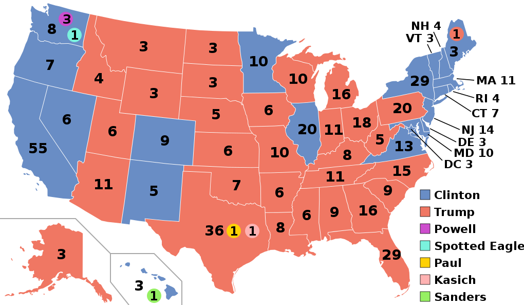
English:
Electoral college map for the
2016 United States presidential election (note: Nebraska and Maine split their EVs by congressional district). |
||||
| Date | |||||
| Source | 2012 Electoral College map | ||||
| Author | Gage | ||||
| Other versions |
|
||||
| SVG development |

.svg)


.svg)
.svg)


Licensing
- You are free:
- to share – to copy, distribute and transmit the work
- to remix – to adapt the work
- Under the following conditions:
- attribution – You must give appropriate credit, provide a link to the license, and indicate if changes were made. You may do so in any reasonable manner, but not in any way that suggests the licensor endorses you or your use.
- share alike – If you remix, transform, or build upon the material, you must distribute your contributions under the same or compatible license as the original.
File history
Click on a date/time to view the file as it appeared at that time.
| Date/Time | Thumbnail | Dimensions | User | Comment | |
|---|---|---|---|---|---|
| current | 03:22, 27 November 2020 |
| 1,020 × 593 (30 KB) | Politicsfan4 | Updated placement of ME-2's electoral vote for consistency with 2020 map |
| 01:22, 5 August 2020 |
 | 1,020 × 593 (30 KB) | Nojus R | Reverted to version as of 07:42, 13 January 2019 (UTC) it looks so weird when every other map uses a different font | |
| 19:31, 10 December 2019 |
 | 1,020 × 593 (30 KB) | IagoQnsi | switching font to Arial, as it looks less-ugly in the server-side rendering // Editing SVG source code using c:User:Rillke/SVGedit.js | |
| 07:42, 13 January 2019 |
 | 1,020 × 593 (30 KB) | Newfraferz87 | (minor) | |
| 02:50, 20 November 2018 |
 | 1,020 × 593 (30 KB) | Newfraferz87 | *DC | |
| 02:35, 20 November 2018 |
 | 1,020 × 593 (30 KB) | Newfraferz87 | Simplify further: coordinates & fills, following this | |
| 14:16, 18 January 2017 |
 | 1,020 × 593 (36 KB) | Newfraferz87 | Shrink size using relative line coordinates. Thanks for the border corrections. | |
| 09:20, 17 January 2017 |
 | 1,020 × 593 (43 KB) | Karlfk | Better borderlines, esp. OH/WV/PA triangle or ID/MT border | |
| 03:14, 12 January 2017 |
 | 1,020 × 593 (36 KB) | PalmerTheGolfer | Reverted to version as of 00:56, 3 January 2017 (UTC) Font of numbers and State line consistency with prior elections more important than a non-existent Libretarian faithless elector change | |
| 22:50, 10 January 2017 |
 | 1,020 × 593 (36 KB) | Maproom | Changed font to Liberation Sans, in the hope of avoiding the problem of "Eagle" extending off the end of the image |
.svg)
File usage
More than 100 pages use this file. The following list shows the first 100 pages that use this file only. A full list is available.
- 2016 Democratic Party presidential candidates
- 2016 Democratic Party presidential primaries
- 2016 Democrats Abroad presidential primary
- 2016 New Hampshire Republican presidential primary
- 2016 Republican Party presidential candidates
- 2016 Republican Party presidential primaries
- 2016 United States elections
- 2016 United States presidential election
- 2016 United States presidential election in Alabama
- 2016 United States presidential election in Alaska
- 2016 United States presidential election in Arizona
- 2016 United States presidential election in Arkansas
- 2016 United States presidential election in California
- 2016 United States presidential election in Colorado
- 2016 United States presidential election in Connecticut
- 2016 United States presidential election in Delaware
- 2016 United States presidential election in Florida
- 2016 United States presidential election in Georgia
- 2016 United States presidential election in Hawaii
- 2016 United States presidential election in Idaho
- 2016 United States presidential election in Illinois
- 2016 United States presidential election in Indiana
- 2016 United States presidential election in Iowa
- 2016 United States presidential election in Kansas
- 2016 United States presidential election in Kentucky
- 2016 United States presidential election in Louisiana
- 2016 United States presidential election in Maine
- 2016 United States presidential election in Maryland
- 2016 United States presidential election in Massachusetts
- 2016 United States presidential election in Michigan
- 2016 United States presidential election in Minnesota
- 2016 United States presidential election in Mississippi
- 2016 United States presidential election in Missouri
- 2016 United States presidential election in Montana
- 2016 United States presidential election in Nebraska
- 2016 United States presidential election in Nevada
- 2016 United States presidential election in New Hampshire
- 2016 United States presidential election in New Jersey
- 2016 United States presidential election in New Mexico
- 2016 United States presidential election in New York
- 2016 United States presidential election in North Carolina
- 2016 United States presidential election in North Dakota
- 2016 United States presidential election in Ohio
- 2016 United States presidential election in Oklahoma
- 2016 United States presidential election in Oregon
- 2016 United States presidential election in Pennsylvania
- 2016 United States presidential election in Rhode Island
- 2016 United States presidential election in South Carolina
- 2016 United States presidential election in South Dakota
- 2016 United States presidential election in Tennessee
- 2016 United States presidential election in Texas
- 2016 United States presidential election in Utah
- 2016 United States presidential election in Vermont
- 2016 United States presidential election in Virginia
- 2016 United States presidential election in Washington (state)
- 2016 United States presidential election in West Virginia
- 2016 United States presidential election in Wisconsin
- 2016 United States presidential election in Wyoming
- 2016 United States presidential election in the District of Columbia
- 2016 United States presidential election in the Northern Mariana Islands
- 2016 United States presidential election in the U.S. Virgin Islands
- 2016 United States presidential primaries in Puerto Rico
- 2016 in the United States
- Donald Trump
- Donald Trump 2016 presidential campaign
- Electoral vote changes between United States presidential elections
- List of United States presidential election results by state
- Presidency of Barack Obama
- Presidency of Donald Trump
- Results of the 2016 Democratic Party presidential primaries
- Results of the 2016 Republican Party presidential primaries
- Third party and independent candidates for the 2016 United States presidential election
- United States presidential election
- Talk:2016 United States presidential election/Archive 10
- Talk:2016 United States presidential election/Archive 12
- Talk:2016 United States presidential election/Archive 13
- Talk:2016 United States presidential election/Archive 21
- Talk:2016 United States presidential election/Archive 9
- User:8isthemagicnumber/sandbox
- User:A lad insane/sandbox/Top viewed articles of 2016
- User:ArcMachaon/sandbox
- User:Eric0928/sandbox4
- User:Ewisk/sandbox
- User:Hogne/us electioons
- User:Kosciuszko's Army/temp EC Open
- User:Lionelt/Foobar/Style guide
- User:Machinekng/sandbox
- User:Mandruss/sandbox
- User:Medibee/sandbox
- User:Quantum Burrito/test new template
- User:Salem Leo/sandbox
- User:Spartan7W/sandbox11
- User:Trumper 12/sandbox
- User:Visigoethe/sandbox
- User:Zootsuit7/sandbox
- Wikipedia:Articles for deletion/Log/2016 February 7
- Wikipedia:Articles for deletion/United States presidential election in District of Columbia, 2016
- Wikipedia:Help desk/Archives/2017 January 10
- Wikipedia:Top 25 Report/2016
- Wikipedia:Top 25 Report/Records
View more links to this file.
Global file usage
The following other wikis use this file:
- Usage on af.wikipedia.org
- Usage on ang.wikipedia.org
- Usage on ar.wikipedia.org
- Usage on arz.wikipedia.org
- Usage on be.wikipedia.org
- Usage on bg.wikipedia.org
- Usage on bn.wikipedia.org
- Usage on bs.wikipedia.org
- Usage on ca.wikipedia.org
- Usage on cdo.wikipedia.org
- Usage on cs.wikipedia.org
- Usage on cy.wikipedia.org
- Usage on da.wikipedia.org
- Usage on de.wikipedia.org
- Usage on dty.wikipedia.org
- Usage on el.wikipedia.org
- Usage on en.wikibooks.org
- Usage on en.wikinews.org
- Usage on eo.wikipedia.org
- Usage on es.wikipedia.org
- Usage on et.wikipedia.org
- Usage on eu.wikipedia.org
- Usage on fa.wikipedia.org
- Usage on fi.wikipedia.org
- Usage on fo.wikipedia.org
View more global usage of this file.