
Size of this preview:
733 × 600 pixels. Other resolutions:
293 × 240 pixels |
587 × 480 pixels |
939 × 768 pixels |
1,067 × 873 pixels.
Original file (1,067 × 873 pixels, file size: 37 KB, MIME type: image/png)
| This is a file from the
Wikimedia Commons. Information from its
description page there is shown below. Commons is a freely licensed media file repository. You can help. |
Summary
| Description |
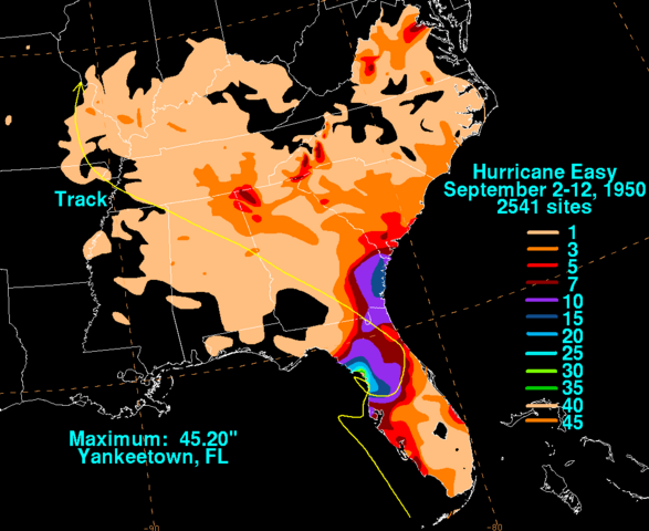
English: Storm total rainfall map of
Hurricane Easy during September 1950. |
|||
| Date | ||||
| Source | WPC tropical cyclone rainfall data | |||
| Author | David Roth, Weather Prediction Center, Camp Springs, Maryland | |||
| Permission ( Reusing this file) |
|
Original upload log
| Date/Time | Dimensions | User | Comment |
|---|---|---|---|
| 4 June 2010, 00:32:46 | 1067 × 873 (39807 bytes) | File Upload Bot (Magnus Manske) ( talk · contribs) | {{BotMoveToCommons|en.wikipedia|year={{subst:CURRENTYEAR}}|month={{subst:CURRENTMONTHNAME}}|day={{subst:CURRENTDAY}}}} {{Information |Description={{en|David Roth Hydrometeorological Prediction Center Camp Springs, MD http://www.hpc.ncep.noaa.gov/tropical |
File history
Click on a date/time to view the file as it appeared at that time.
| Date/Time | Thumbnail | Dimensions | User | Comment | |
|---|---|---|---|---|---|
| current | 18:58, 6 January 2015 |
| 1,067 × 873 (37 KB) | GifTagger | Bot: Converting file to superior PNG file. (Source: Easy_1950_rainfall.gif). This GIF was problematic due to non-greyscale color table. |
File usage
The following pages on the English Wikipedia use this file (pages on other projects are not listed):
Global file usage
The following other wikis use this file:
- Usage on de.wikipedia.org
- Usage on es.wikipedia.org
- Usage on zh.wikipedia.org