
Original file (1,318 × 720 pixels, file size: 512 KB, MIME type: image/jpeg)
| This is a file from the
Wikimedia Commons. Information from its
description page there is shown below. Commons is a freely licensed media file repository. You can help. |
Summary
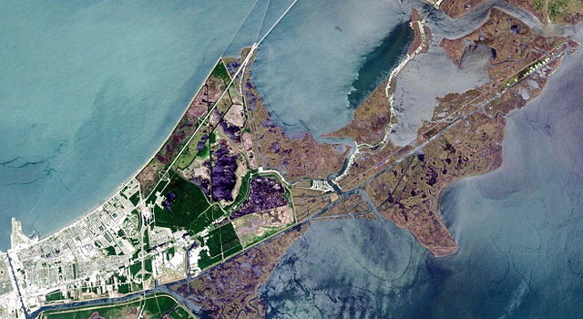
Eastern New Orleans as seen from space. Cropped from NASA Landsat image.
Industrial Canal runs vertically (roughly north-south) at bottom left. At top left is Lake Pontchartrain. Lakefront Airport is peninsula at left. Intracoastal Waterway stretches horizontally near bottom left, with the Intracoastal continuing to right and the Mississippi River Gulf Outlet (MR-GO) extending towards the bottom from "Y" branch near bottom center. Purple-colored area to right of deep green is part of Bayou Sauvage National Wildlife Refuge.
Chef Menteur Pass cuts through the center, to the right of wildlife refuge. At top right is the Rigolets pass. Both intersect with the obviously man-made Intracoastal. Lake Borgne is at bottom right.
Licensing
| This file is in the public domain in the United States because it was solely created by NASA. NASA copyright policy states that "NASA material is not protected by copyright unless noted". (See Template:PD-USGov, NASA copyright policy page or JPL Image Use Policy.) | ||
 |
Warnings:
|
File history
Click on a date/time to view the file as it appeared at that time.
| Date/Time | Thumbnail | Dimensions | User | Comment | |
|---|---|---|---|---|---|
| current | 19:45, 16 April 2006 |
| 1,318 × 720 (512 KB) | Infrogmation | Eastern New Orleans as seen from space. Cropped from NASA Landsat image. Industrial Canal at runs vertically (roughly north-south) at bottom left. At top left is Lake Pontchartrain. Lakefront Airport is peninsula at left. Gulf Intracoastal Wa |
File usage
Global file usage
The following other wikis use this file:
- Usage on es.wikipedia.org
- Usage on www.wikidata.org