Size of this preview:
483 × 599 pixels. Other resolutions:
193 × 240 pixels |
387 × 480 pixels |
767 × 952 pixels.
Original file (767 × 952 pixels, file size: 406 KB, MIME type: image/jpeg)
File history
Click on a date/time to view the file as it appeared at that time.
| Date/Time | Thumbnail | Dimensions | User | Comment | |
|---|---|---|---|---|---|
| current | 15:48, 6 March 2024 |
 | 767 × 952 (406 KB) | OrionNimrod | original, nationalist Romanian editor always put Wallachian/Romanians in every old maps |
| 15:13, 14 January 2024 |
 | 767 × 952 (378 KB) | Nihil scimus | The fact that the northern shores of the Black Sea were a passage corridor for migratory steppe peoples is historically established. But for Russian nationalists who want to anticipate their domination in Moldova by a thousand years, anything that does not align with their position is "bad faith". | |
| 16:53, 23 October 2022 |
 | 767 × 952 (388 KB) | Gyalu22 | Changed bad faith edit in accordance to the cited atlas. | |
| 21:26, 27 June 2019 |
 | 767 × 952 (378 KB) | Nicoljaus | W. Croats replaced by Croats according to the cited related source http://izbornyk.org.ua/litop/map_viii_ix.htm | |
| 19:14, 12 January 2018 |
 | 767 × 952 (425 KB) | Velivieras | Corrected Finns and Tavastians. Added Votes and Izhorians. | |
| 21:12, 19 July 2014 |
 | 767 × 952 (430 KB) | Spiridon Ion Cepleanu | Little changes according with the H.E. Stier's (dir.), « Westermann Grosser Atlas zur Weltgeschichte », 1985, ISBN 3-14-100919-8, the « Putzger historischer Weltatlas Cornelsen » 1990, ISBN 3-464-00176-8, the « Atlas historique Georges Duby ... | |
| 16:49, 28 April 2011 |
 | 767 × 952 (406 KB) | SeikoEn | Reverted to version as of 16:07, 26 August 2010 | |
| 15:56, 27 April 2011 |
 | 684 × 645 (255 KB) | Dbachmann | crop | |
| 16:07, 26 August 2010 |
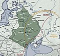
 | 767 × 952 (406 KB) | SeikoEn | {{Information |Description={{en|1=European territory inahibted by East Slavic tribes in 8th and 9th century.}} |Source={{own}}, related sources: http://izbornyk.org.ua/litop/map_viii_ix.htm |Author= SeikoEn |Date=2010. |Permission= |other_ |
File usage
The following pages on the English Wikipedia use this file (pages on other projects are not listed):
Global file usage
The following other wikis use this file:
- Usage on af.wikipedia.org
- Usage on ar.wikipedia.org
- Usage on ast.wikipedia.org
- Usage on azb.wikipedia.org
- Usage on be-tarask.wikipedia.org
- Usage on be.wikipedia.org
- Usage on bg.wikipedia.org
- Usage on bs.wikipedia.org
- Usage on ca.wikipedia.org
- Usage on cs.wikipedia.org
- Usage on cv.wikipedia.org
- Usage on da.wikipedia.org
- Usage on de.wikipedia.org
- Usage on el.wikipedia.org
- Usage on es.wikipedia.org
- Usage on et.wikipedia.org
- Usage on eu.wikipedia.org
- Usage on fi.wikipedia.org
- Usage on fr.wikipedia.org
View more global usage of this file.
