No higher resolution available.
East-West_Link.png (783 × 338 pixels, file size: 397 KB, MIME type: image/png)
| This is a file from the
Wikimedia Commons. Information from its
description page there is shown below. Commons is a freely licensed media file repository. You can help. |
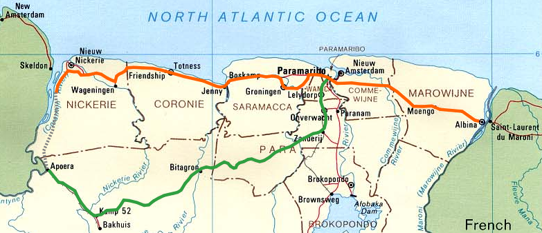
| Description | The East-West Link in Suriname. |
| Date | (UTC) |
| Source | |
| Author |
|
| This is a
retouched picture, which means that it has been digitally altered from its original version. Modifications: cropped, added East-West Link. The original can be viewed here:
Suriname pol91.jpg:
|
This work is in the
public domain in the United States because it is a
work prepared by an officer or employee of the United States Government as part of that person’s official duties under the terms of
Title 17, Chapter 1, Section 105 of the
US Code.
Note: This only applies to original works of the Federal Government and not to the work of any individual
U.S. state,
territory, commonwealth, county, municipality, or any other subdivision. This template also does not apply to postage stamp designs published by the
United States Postal Service
since 1978. (See §
313.6(C)(1) of Compendium of U.S. Copyright Office Practices). It also does not apply to certain US coins; see
The US Mint Terms of Use.
|
 | |
| This file has been identified as being free of known restrictions under copyright law, including all related and neighboring rights. | ||
Original upload log
This image is a derivative work of the following images:
-
File:Suriname_pol91.jpg licensed with PD-USGov
- 2005-09-02T01:45:54Z Rex 1078x1300 (177177 Bytes) Suriname, political map (1991). Produced by the U.S. Central Intelligence Agency. Secondary source: [http://www.lib.utexas.edu/maps/suriname.html Perry-Castañeda Library]
Uploaded with derivativeFX
File history
Click on a date/time to view the file as it appeared at that time.
| Date/Time | Thumbnail | Dimensions | User | Comment | |
|---|---|---|---|---|---|
| current | 00:37, 24 February 2010 |
| 783 × 338 (397 KB) | Fentener van Vlissingen | {{Information |Description=The East-West Link in Suriname. |Source=* File:Suriname_pol91.jpg |Date=2010-02-24 00:35 (UTC) |Author=* File:Suriname_pol91.jpg: US Government *derivative work: ~~~ |Permission=see below |other_versions= }} {{Retouch |
File usage
The following pages on the English Wikipedia use this file (pages on other projects are not listed):
Global file usage
The following other wikis use this file:
- Usage on es.wikipedia.org
- Usage on ja.wikipedia.org
- Usage on ml.wikipedia.org
- Usage on nl.wikipedia.org
- Usage on ru.wikipedia.org
- Usage on www.wikidata.org