
Size of this preview:
400 × 600 pixels. Other resolutions:
160 × 240 pixels |
320 × 480 pixels |
512 × 768 pixels |
682 × 1,024 pixels |
1,365 × 2,048 pixels |
2,912 × 4,368 pixels.
Original file (2,912 × 4,368 pixels, file size: 2.75 MB, MIME type: image/jpeg)
| This is a file from the
Wikimedia Commons. Information from its
description page there is shown below. Commons is a freely licensed media file repository. You can help. |
Summary
| Description |
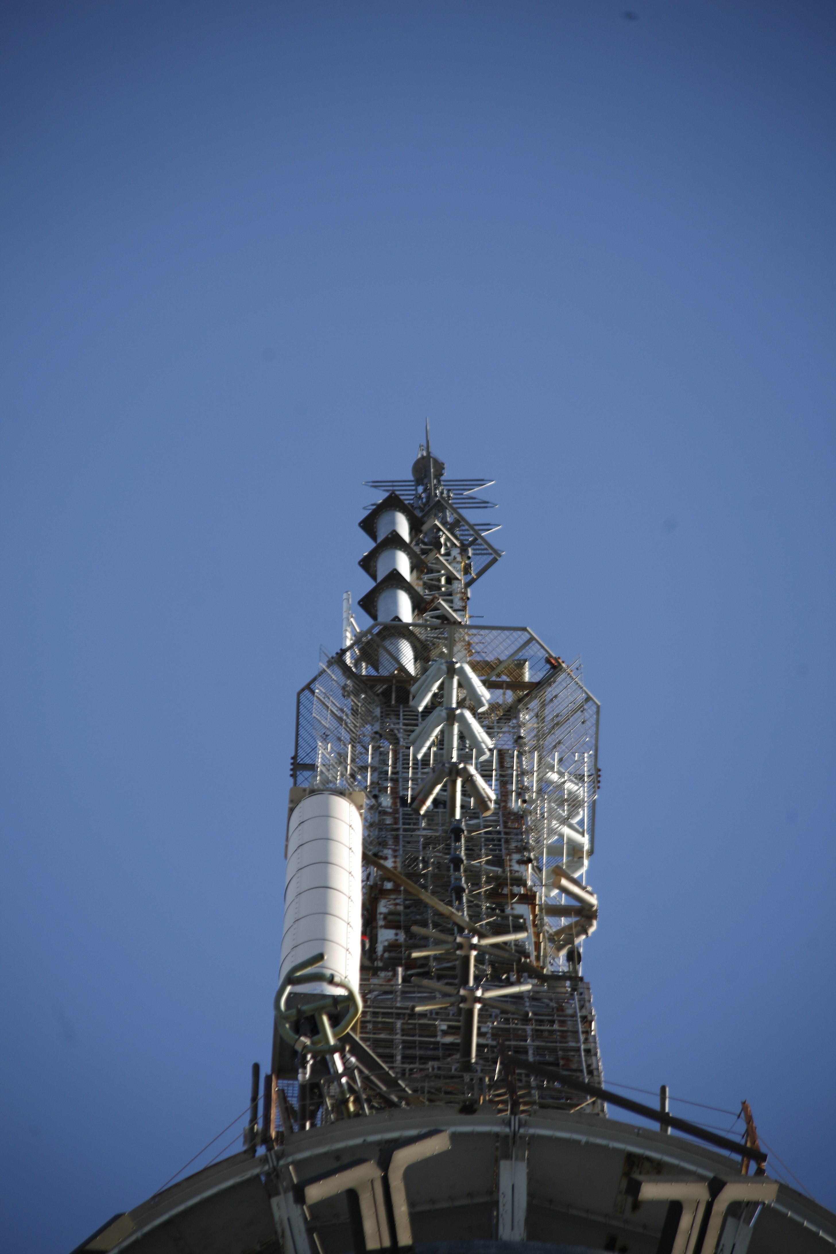
English: Atop is an ERI master antenna. The story of its installation is www.eriinc.com/news/pressroom/silliman_on_top.pdf. Stations radiating from the top two bays include WQXR/105.9, WNYC-FM/93.9, WLTW/106.7, WSKQ/97/9, WXNY/96.3, WWFS/102.7, WEPN/98.7, WBAI/99.5, WBLS/107.5, WWPR/105.1, WHTZ/100.3, WXRK/92.3, WAXQ/104.3 and WKTU/103.5. All are 6kw horizontal and vertical except for WBAI (4.3), WBLS (4.2) and WQXR (.61). WFAN/101.9 uses the bottom gold bay, and produces 6.2kw. Next down is a WPLJ/95.5 auxiliary antenna (6.6kw) and then three stations sharing a two-bay panel antenna: WQHT/97.1, WPLJ/95.5 and WCBS-FM/101.1. All three are 6.7kw. The old Alford can be seen below. |
| Date | |
| Source | https://www.flickr.com/photos/infrastructure/4273976047/ |
| Author | Doc Searls |
| Camera location |
| View this and other nearby images on: OpenStreetMap |
|
|---|
Licensing
This file is licensed under the
Creative Commons
Attribution 2.0 Generic license.
- You are free:
- to share – to copy, distribute and transmit the work
- to remix – to adapt the work
- Under the following conditions:
- attribution – You must give appropriate credit, provide a link to the license, and indicate if changes were made. You may do so in any reasonable manner, but not in any way that suggests the licensor endorses you or your use.
| This image was originally posted to Flickr by Nfrastructure at https://flickr.com/photos/46167543@N05/4273976047 ( archive). It was reviewed on 8 October 2019 by FlickreviewR 2 and was confirmed to be licensed under the terms of the cc-by-2.0. |
File history
Click on a date/time to view the file as it appeared at that time.
| Date/Time | Thumbnail | Dimensions | User | Comment | |
|---|---|---|---|---|---|
| current | 00:20, 8 October 2019 |
| 2,912 × 4,368 (2.75 MB) | Koavf | User created page with UploadWizard |
File usage
No pages on the English Wikipedia use this file (pages on other projects are not listed).