
Size of this PNG preview of this SVG file:
520 × 500 pixels. Other resolutions:
250 × 240 pixels |
499 × 480 pixels |
799 × 768 pixels |
1,065 × 1,024 pixels |
2,130 × 2,048 pixels.
Original file (SVG file, nominally 520 × 500 pixels, file size: 26 KB)
| This is a file from the
Wikimedia Commons. Information from its
description page there is shown below. Commons is a freely licensed media file repository. You can help. |
| Description | |||
| Date | |||
| Source | Based on en:File:EarthTangentialPlane.png by en:User:Raffyl99 (public domain) | ||
| Author | Mike1024 | ||
| Permission ( Reusing this file) |
|
||
| Other versions | en:File:EarthTangentialPlane.png |
File history
Click on a date/time to view the file as it appeared at that time.
| Date/Time | Thumbnail | Dimensions | User | Comment | |
|---|---|---|---|---|---|
| current | 22:49, 18 February 2010 |
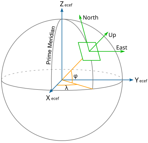
| 520 × 500 (26 KB) | Mike1024 | {{Information |Description={{en|A diagram showing ECEF, ENU, Longitude (λ) and Latitude (φ) coordinates and the relationship between them.}} |Source=Based on [[:en:File:EarthTangenti |
File usage
The following pages on the English Wikipedia use this file (pages on other projects are not listed):
Global file usage
The following other wikis use this file:
- Usage on cs.wikipedia.org
- Usage on ha.wikipedia.org
- Usage on he.wikipedia.org
- Usage on hi.wikipedia.org
- Usage on ru.wikipedia.org
- Usage on sh.wikipedia.org
- Usage on tr.wikipedia.org
- Usage on uz.wikipedia.org