
Size of this preview:
800 × 455 pixels. Other resolutions:
320 × 182 pixels |
640 × 364 pixels |
990 × 563 pixels.
Original file (990 × 563 pixels, file size: 270 KB, MIME type: image/jpeg)
| This is a file from the
Wikimedia Commons. Information from its
description page there is shown below. Commons is a freely licensed media file repository. You can help. |
| Description |
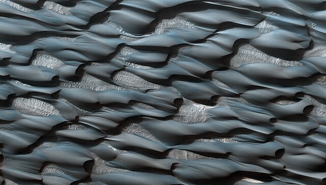
English: The Abalos Undae dune field stretches westward, away from a portion (Abalos Colles) of the ice-rich north polar layered deposits that is separated from the main Planum Boreum dome by two large chasms. These dunes are special because their sands may have been derived from erosion of the Rupes Tenuis unit (the lowest stratigraphic unit in Planum Boreum, beneath the icier layers) during formation of the chasms. Some researchers have argued that these chasms were formed partially by melting of the polar ice.
The enhanced color data illuminate differences in composition. The dunes appear blueish because of their basaltic composition, while the reddish-white areas are probably covered in dust. Upon close inspection, tiny ripples and grooves are visible on the surface of the dunes; these features are formed by wind action, as are the dunes themselves. It is possible that the dunes are no longer migrating (the process of dune formation forces dunes to move in the direction of the main winds) and that the tiny ripples are the only active parts of the dunes today. Scale: [1]. Field of view is roughly 1.25 km x 2.2 km. Individual dunes are around 200 to 300 meters long. |
|||||
| Date | ||||||
| Source | http://www.boston.com/bigpicture/2009/11/martian_landscapes.html | |||||
| Author | NASA HiRISE camera, Mars Reconnaissance Orbiter. | |||||
| Permission ( Reusing this file) |
|
|||||
| Other versions | Geology: Dunes in Abalos Undae |

![[1]](http://hirise-pds.lpl.arizona.edu/PDS/EXTRAS/RDR/PSP/ORB_010200_010299/PSP_010219_2785/PSP_010219_2785_COLOR.abrowse.jpg)
File history
Click on a date/time to view the file as it appeared at that time.
| Date/Time | Thumbnail | Dimensions | User | Comment | |
|---|---|---|---|---|---|
| current | 04:34, 26 January 2014 |
| 990 × 563 (270 KB) | Tillman | {{Information |Description ={{en|1=The Abalos Undae dune field stretches westward, away from a portion (Abalos Colles) of the ice-rich north polar layered deposits that is separated from the main Planum Boreum dome by two large chasms. These dunes a... |
File usage
The following pages on the English Wikipedia use this file (pages on other projects are not listed):
Global file usage
The following other wikis use this file:
- Usage on ca.wikipedia.org
- Usage on de.wikipedia.org
- Usage on es.wikipedia.org
- Usage on fr.wikipedia.org
- Usage on hu.wikipedia.org
- Usage on id.wikipedia.org
- Usage on nl.wikipedia.org
- Usage on uk.wikipedia.org
- Usage on www.wikidata.org
- Usage on zh.wikipedia.org