Size of this preview:
800 × 530 pixels. Other resolutions:
320 × 212 pixels |
640 × 424 pixels |
1,031 × 683 pixels.
Original file (1,031 × 683 pixels, file size: 149 KB, MIME type: image/jpeg)
| This is a file from the
Wikimedia Commons. Information from its
description page there is shown below. Commons is a freely licensed media file repository. You can help. |
.jpg)
Summary
| Description |
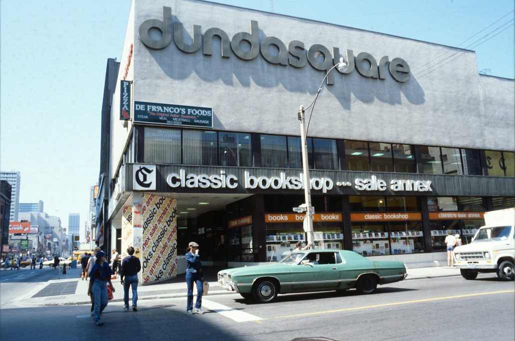
English: Looking north on Yonge Street at its intersection with the side street called Dundas Square. The building called Dundas Square, containing a Classic Book Store, has since been demolished to make way for a public square called Yonge-Dundas Square. |
||
| Date | circa 1979 | ||
| Source |
|
||
| Author | City of Toronto Planning and Development Department |
| Camera location |
| View this and other nearby images on: OpenStreetMap |
|
|---|
.jpg¶ms=043.655713_N_-079.380447_E_globe:Earth_type:camera_source:Flickr_&language=en)
Licensing
This file is licensed under the
Creative Commons
Attribution 2.0 Generic license.
- You are free:
- to share – to copy, distribute and transmit the work
- to remix – to adapt the work
- Under the following conditions:
- attribution – You must give appropriate credit, provide a link to the license, and indicate if changes were made. You may do so in any reasonable manner, but not in any way that suggests the licensor endorses you or your use.
| This image, originally posted to Flickr, was reviewed on August 10, 2011 by the administrator or reviewer File Upload Bot (Magnus Manske), who confirmed that it was available on Flickr under the stated license on that date. |
File history
Click on a date/time to view the file as it appeared at that time.
| Date/Time | Thumbnail | Dimensions | User | Comment | |
|---|---|---|---|---|---|
| current | 19:46, 10 August 2011 |
| 1,031 × 683 (149 KB) | Skeezix1000 | cropped |
| 16:11, 10 August 2011 |
 | 1,050 × 728 (156 KB) | File Upload Bot (Magnus Manske) | {{Information |Description=Photographer: City of Toronto Planning and Development Department ca. 1979 [http://www.toronto.ca/archives/index.htm City of Toronto Archives] Series 1465, File 308, Item 6 |Source=[http://www.flickr.com/photos/torontohistory/60 |
File usage
The following pages on the English Wikipedia use this file (pages on other projects are not listed):
Global file usage
The following other wikis use this file:
- Usage on fi.wikipedia.org
.jpg)