
Size of this PNG preview of this SVG file:
800 × 544 pixels. Other resolutions:
320 × 218 pixels |
640 × 435 pixels |
1,024 × 696 pixels |
1,280 × 870 pixels |
2,560 × 1,741 pixels |
1,425 × 969 pixels.
Original file (SVG file, nominally 1,425 × 969 pixels, file size: 1.97 MB)
| This is a file from the
Wikimedia Commons. Information from its
description page there is shown below. Commons is a freely licensed media file repository. You can help. |
| Description |
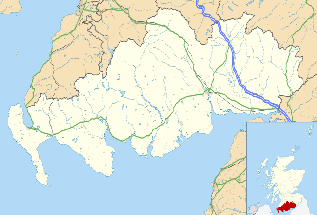
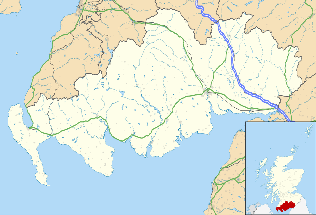
Blank map of Dumfries and Galloway, UK with the following information shown:
Equirectangular map projection on WGS 84 datum, with N/S stretched 170% Geographic limits:
|
| Date | |
| Source |
|
| Author | Nilfanion, created using Ordnance Survey data |
| Permission ( Reusing this file) |
This file is licensed under the
Creative Commons
Attribution-Share Alike 3.0 Unported license. Attribution: Contains Ordnance Survey data © Crown copyright and database right
|
| Other versions | File:Dumfries and Galloway UK blank map.svg - Blank map |
File history
Click on a date/time to view the file as it appeared at that time.
| Date/Time | Thumbnail | Dimensions | User | Comment | |
|---|---|---|---|---|---|
| current | 20:07, 26 September 2010 |
| 1,425 × 969 (1.97 MB) | Nilfanion | {{Information |Description=Blank map of Dumfries and Galloway, UK with the following information shown: *Administrative borders *Coastline, lakes and rivers *Roads and railways *Urban areas Equirectangular map projection on WG |
File usage
More than 100 pages use this file. The following list shows the first 100 pages that use this file only. A full list is available.
- Abbey Head
- Ae, Dumfries and Galloway
- Amisfield
- Annan, Dumfries and Galloway
- Annan railway station
- Annandale Water services
- Applegarthtown
- Ardwell
- Arkleton
- Auchencairn
- Auldgirth
- Balmaghie
- Beattock
- Borgue, Dumfries and Galloway
- Borness
- Browhouses
- Caerlaverock Castle
- Cairngaan
- Cairnryan
- Canonbie
- Carsluith Castle
- Carsphairn
- Castle Douglas
- Creetown
- Cummertrees
- Dalbeattie
- Dalbeattie Star F.C.
- Dalton, Dumfries and Galloway
- Dornock
- Drummore
- Dumfries
- Dumfries and Galloway
- Dumfries and Galloway Royal Infirmary
- Dundrennan
- Dunragit
- Durisdeer
- Eastriggs
- Ecclefechan
- Eskdalemuir
- Galabank
- Galloway Community Hospital
- Garlieston
- Gatehouse of Fleet
- Glasserton
- Glencaple
- Glenluce
- Gretna, Dumfries and Galloway
- Gretna Green
- Gretna Green railway station
- Haugh of Urr
- Isle of Whithorn
- Kagyu Samye Ling Monastery and Tibetan Centre
- Kippford
- Kirkconnel
- Kirkcowan
- Kirkcudbright
- Kirkmaiden
- Langholm
- List of monastic houses in Scotland
- Lochans, Dumfries and Galloway
- Locharbriggs
- Lochmaben
- Lochmaben Stone
- Lockerbie
- Luce Bay
- Millhousebridge
- Mochrum
- Moffat
- Moniaive
- Mull of Galloway
- New Abbey
- New Galloway
- New Luce
- Newton Stewart
- Newton Wamphray
- Orchardton Tower
- Palmerston Park
- Palnackie
- Penpont
- Port Logan
- Port William, Dumfries and Galloway
- Portpatrick
- RAF West Freugh
- Raydale Park
- Rockcliffe, Dumfries and Galloway
- Ruthwell
- Sandhead
- Sanquhar
- Sorbie
- South of Scotland Football League
- St John's Town of Dalry
- Stair Park
- Stoneykirk
- Stranraer
- The Crichton
- Thornhill, Dumfries and Galloway
- Tongland
- Torhouse
- Twynholm
- Wanlockhead
View more links to this file.
Global file usage
The following other wikis use this file:
- Usage on ar.wikipedia.org
- Usage on bg.wikipedia.org
- Usage on ceb.wikipedia.org
- Usage on de.wikipedia.org
- Usage on eo.wikipedia.org
- Usage on es.wikipedia.org
- Dumfries
- Wikiproyecto:Ilustración/Taller de Cartografía/Realizaciones/Europa
- Plantilla:Mapa de localización de Dumfries and Galloway
- Kirkcudbright
- Annan
- Locharbriggs
- Langholm
- Kirkconnel
- Gretna (Escocia)
- Thornhill (Dumfries and Galloway)
- Glenluce
- Creetown
- Eastriggs
- Newton Stewart
- Gatehouse of Fleet
- Ecclefechan
- Moniaive
- Lochmaben
- Whithorn
- Wigtown
- Stranraer
- Sanquhar
- Castle Douglas
- Cargenbridge
- Cairnholy
- Usage on fa.wikipedia.org
View more global usage of this file.