
Size of this preview:
633 × 599 pixels. Other resolutions:
254 × 240 pixels |
507 × 480 pixels |
811 × 768 pixels |
1,052 × 996 pixels.
Original file (1,052 × 996 pixels, file size: 1.91 MB, MIME type: image/png)
| This is a file from the
Wikimedia Commons. Information from its
description page there is shown below. Commons is a freely licensed media file repository. You can help. |
Summary
| Description |
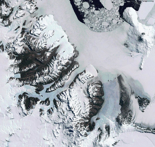
English: Mosaic of Landsat images, showing McMurdo Sound (right) and the Dry Valleys (left). Part of Ross Island is visible upper right. |
| Date | LIMA is a mosaic of Landsat images taken "primarily during 1999-2003". |
| Source | Landsat Image Mosaic of Antarctica (LIMA). Slightly different view from the one linked here. |
| Author | USGS/NASA |
Licensing
| This file is in the public domain in the United States because it was solely created by NASA. NASA copyright policy states that "NASA material is not protected by copyright unless noted". (See Template:PD-USGov, NASA copyright policy page or JPL Image Use Policy.) | ||
 |
Warnings:
|
File history
Click on a date/time to view the file as it appeared at that time.
| Date/Time | Thumbnail | Dimensions | User | Comment | |
|---|---|---|---|---|---|
| current | 12:23, 25 April 2009 |
| 1,052 × 996 (1.91 MB) | Avenue | {{Information |Description={{en|1=Mosaic of Landsat images, showing McMurdo Sound (right) and the Dry Valleys (left). Part of Ross Island is visible upper right.}} |Source=Source: Landsat Image Mosaic of Antarctica (LIMA). Slightly different view from the |
File usage
The following pages on the English Wikipedia use this file (pages on other projects are not listed):