
Size of this JPG preview of this PDF file:
800 × 535 pixels. Other resolutions:
320 × 214 pixels |
640 × 428 pixels |
1,024 × 685 pixels |
1,280 × 857 pixels |
2,468 × 1,652 pixels.
Original file (2,468 × 1,652 pixels, file size: 64.73 MB, MIME type: application/pdf)
| This is a file from the
Wikimedia Commons. Information from its
description page there is shown below. Commons is a freely licensed media file repository. You can help. |
Summary
| Description |
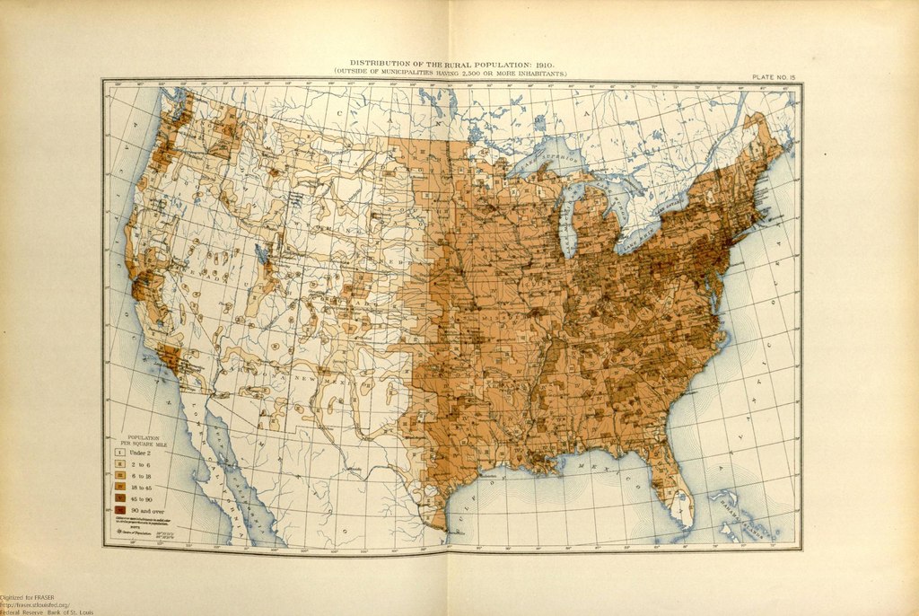
English: This map shows the population distribution of the 46 states and 2 territories of the mainland United States and the remaining extent of the frontier by 1910. |
| Date | |
| Source | United States. Bureau of the Census. "Illustrations: Population" in Statistical Atlas of the United States, 1910 (July 1914). https://fraser.stlouisfed.org/title/74/item/492434, accessed on January 6, 2020. |
| Author | United States Census Bureau |
Licensing
This image or file is a work of a
United States Census Bureau employee, taken or made as part of that person's official duties. As a
work of the
U.S. federal government, the image is in the
public domain.
|
 |
File history
Click on a date/time to view the file as it appeared at that time.
| Date/Time | Thumbnail | Dimensions | User | Comment | |
|---|---|---|---|---|---|
| current | 20:05, 6 January 2020 |
 | 2,468 × 1,652 (64.73 MB) | Killroy is here | User created page with UploadWizard |
File usage
The following pages on the English Wikipedia use this file (pages on other projects are not listed):